If you wish to contribute or participate in the discussions about articles you are invited to contact the Editor
Galileo General Introduction: Difference between revisions
Gema.Cueto (talk | contribs) No edit summary |
Gema.Cueto (talk | contribs) No edit summary |
||
| Line 34: | Line 34: | ||
==GALILEO Services== | ==GALILEO Services== | ||
The Galileo mission and services were elaborated during the initial definition phase in consultation with user communities and the Member States. The high-performance services that will be provided once Galileo system is fully operational, are the following:<ref name="Galileo services in European GNSS Service Centre portal">[https://www.gsc-europa.eu/galileo/services Galileo services in European GNSS Service Centre portal]</ref> | The Galileo mission and services were elaborated during the initial definition phase in consultation with user communities and the Member States. The high-performance services that will be provided once Galileo system is fully operational, are the following:<ref name="Galileo services in European GNSS Service Centre portal">[https://www.gsc-europa.eu/galileo/services Galileo services in European GNSS Service Centre portal]</ref> | ||
* [[GALILEO Open Service|Open Service (OS)]]: With positioning accurate to one metre, the freely accessible Open Service targets the mass market and is intended for motor vehicle navigation and location-based mobile telephone services. Free to the user, it provides positioning and synchronization information intended for high-volume satellite radio navigation applications; | * [[GALILEO Open Service|Open Service (OS)]]: With positioning accurate to one metre, the freely accessible Open Service targets the mass market and is intended for motor vehicle navigation and location-based mobile telephone services. Free to the user, it provides positioning and synchronization information intended for high-volume satellite radio navigation applications; Galileo Open Service will include in the short term an authentication mechanism through [[Galileo OS-NMA | Galileo Open Service Navigation Message Authentication]]. | ||
* [[GALILEO Commercial Service|High Accuracy Service (HAS)]]: a service complementing the OS by providing an additional navigation signal and added value services in a different frequency band. The HAS signal can be encrypted in order to control the access to the Galileo HAS services; | * [[GALILEO Commercial Service|High Accuracy Service (HAS)]]: a service complementing the OS by providing an additional navigation signal and added value services in a different frequency band. The HAS signal can be encrypted in order to control the access to the Galileo HAS services; | ||
* [[GALILEO Public Regulated Service|Public Regulated Service (PRS)]]: The Public Regulated Service is restricted to government-authorised users, for sensitive applications which require a high level of service continuity. It will be encrypted and designed to be more robust, with anti-jamming mechanisms and reliable problem detection. This service is intended for security and strategic infrastructure (e.g. energy, telecommunications and finance); | * [[GALILEO Public Regulated Service|Public Regulated Service (PRS)]]: The Public Regulated Service is restricted to government-authorised users, for sensitive applications which require a high level of service continuity. It will be encrypted and designed to be more robust, with anti-jamming mechanisms and reliable problem detection. This service is intended for security and strategic infrastructure (e.g. energy, telecommunications and finance); | ||
Revision as of 11:10, 29 January 2021
| GALILEO | |
|---|---|
| Title | Galileo General Introduction |
| Edited by | GMV |
| Level | Basic |
| Year of Publication | 2011 |
Galileo is Europe’s own global navigation satellite system, providing a highly accurate, guaranteed global positioning service under civilian control. It is inter-operable with GPS and GLONASS. Galileo receivers compute their position in the Galileo Reference System using satellite technology and based on triangulation principles.
The Galileo system started its initial services on December 15th, 2016.[1] The services will evolve with the infrastructure deployment until the Full Operational Capability (FOC) is achieved.
Introduction
The Galileo program is Europe's initiative for a state-of-the-art global satellite navigation system, providing a highly accurate, guaranteed global positioning service under civilian control.[2][3] While providing autonomous navigation and positioning services, Galileo is interoperable with other GNSS systems such as GPS and GLONASS.[3] The system, when fully deployed, will consist of 30 satellites, to be deployed in a staggered approach, and the associated ground infrastructure.[4].
A user is able to take a position with the same receiver from any of the satellites in any combination. By offering dual frequencies as standard, Galileo delivers real-time positioning accuracy down to the meter range. It guarantees availability of the service under the most extreme circumstances and informs users of a failure of any satellite.
GPS (US), GLONASS (Russia), BeiDou (China) and the regional system developed by Japan (QZSS) are military systems under military control – indeed they provide a civil service but that civil service could be either switched off or made less precise when desired (e.g. in case of conflict). The world has become so dependent on services provided by satellite navigation in our daily lives that should a service be reduced or switched off, the potential disruption to business, banking, transport, aviation, communication, etc., to name but a few, would be very costly (e.g. in terms of revenues for business, road safety, etc.).[5]
The combination of Galileo and GPS signals (inter-operability) in dual receivers opens the door to new GNSS applications that require a higher level of precision than currently available with GPS alone. From most locations, six to eight Galileo satellites will be visible which, in combination with GPS signals, will allow positions to be determined up to within a few centimetres. Examples of these applications are: guide the blind, increase the success rate of rescue operations in the mountains, monitor the whereabouts of people suffering from Alzheimer Disease, etc.[5]
In addition, Galileo improves the overall availability and coverage of GNSS signals. For example, the higher number of satellites improves the availability of the signals in high rise cities where buildings can obstruct signals from satellites that are low on the horizon.[5]
With Galileo, Europe is able to exploit the opportunities provided by satellite navigation to the full extent. GNSS receiver and equipment manufacturers, application providers and service operators benefit from novel business opportunities.[5][6]
History and Development
As far back as the 1990s, the European Union saw the need for Europe to have its own global satellite navigation system.[2] The conclusion to build one was taken in similar spirit to decisions in the 1970s to embark on other well-known European endeavours, such as the Ariane launcher and the Airbus. The European Commission and European Space Agency joined forces to build Galileo, an independent European system under civilian control.
The definition phase and the development and In-Orbit Validation phase of the Galileo program were carried out by the European Space Agency (ESA) and co-funded by ESA and the European Union. The Full Operational Capability phase of the Galileo program is fully funded by the European Union and managed by the European Commission. The Commission and ESA signed a delegation agreement by which ESA acts as design and procurement agent on behalf of the Commission.
The Galileo program was structured according to three main phases:[5] In-Orbit Validation (IOV), Initial Operational Capability (IOC) and Full Operational Capability (FOC) phases.
GALILEO Services
The Galileo mission and services were elaborated during the initial definition phase in consultation with user communities and the Member States. The high-performance services that will be provided once Galileo system is fully operational, are the following:[7]
- Open Service (OS): With positioning accurate to one metre, the freely accessible Open Service targets the mass market and is intended for motor vehicle navigation and location-based mobile telephone services. Free to the user, it provides positioning and synchronization information intended for high-volume satellite radio navigation applications; Galileo Open Service will include in the short term an authentication mechanism through Galileo Open Service Navigation Message Authentication.
- High Accuracy Service (HAS): a service complementing the OS by providing an additional navigation signal and added value services in a different frequency band. The HAS signal can be encrypted in order to control the access to the Galileo HAS services;
- Public Regulated Service (PRS): The Public Regulated Service is restricted to government-authorised users, for sensitive applications which require a high level of service continuity. It will be encrypted and designed to be more robust, with anti-jamming mechanisms and reliable problem detection. This service is intended for security and strategic infrastructure (e.g. energy, telecommunications and finance);
- Search and Rescue Service (SAR): Galileo's worldwide search and rescue service will help to forward distress signals to a rescue coordination centre by detecting emergency signals transmitted by beacons and relaying messages to them.
The initial series offered by Galileo are the Open Service, the Public Regulated Service (PRS) and the Search and Rescue Service(SAR).
GALILEO Architecture
To ensure these Galileo services, a specific architecture is deployed. The Galileo system is divided into three major segments: Space Segment, Ground Segment and User Segment. For details see Galileo Architecture.
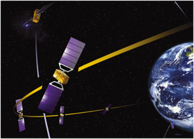
The main functions of the Galileo Space Segment are to generate and transmit code and carrier phase signals with a specific Galileo signal structure, and to store and retransmit the navigation message sent by the Ground Segment. These transmissions are controlled by highly stable atomic clocks on board the satellites.
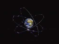
When Galileo is fully operational, there will be 30 satellites in Medium Earth Orbit (MEO) at an altitude of 23,222 kilometres. The satellites will occupy each of three orbital planes inclined at an angle of 56° to the equator. The satellites will be spread evenly around each plane and will take about 14 hours to orbit the Earth. Two satellites in each plane will be a spare; on stand-by should any operational satellite fail[4].
The Galileo Ground Segment (also referred to as Control Segment) is the responsible for the proper operation of the GNSS system. Its basic functions are:
- To control and maintain the status and configuration of the satellite constellation.
- To predict ephemeris and satellite clock evolution.
- To keep the corresponding GNSS time scale (through atomic clocks).
- To update the navigation messages for all the satellites.
The Galileo Ground Segment constitutes the major system element controlling the entire constellation, the navigation system facilities and the dissemination services. It is composed of two Ground Control Centres (GCC), a network of Telemetry, Tracking and Control (TT&C) stations, a network of Mission Uplink Stations (ULS), and a network of Galileo Sensor Stations (GSS)[4].
The Galileo user segment is composed of Galileo receivers. Their main function is to receive Galileo signals, determine pseudoranges (and other observables), and solve the navigation equations in order to obtain their coordinates and provide a very accurate time.
Galileo Signal Characteristics
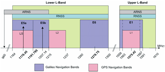
The Galileo navigation Signals are transmitted in the four frequency bands indicated in next figure. These four frequency bands are the E5a, E5b, E6 and E1 bands. They provide a wide bandwidth for the transmission of the Galileo Signals.[8]
The Galileo frequency bands have been selected in the allocated spectrum for Radio Navigation Satellite Services (RNSS). In addition to that, E5a, E5b and E1 bands are included in the allocated spectrum for Aeronautical Radio Navigation Services (ARNS), employed by Civil-Aviation users, and allowing dedicated safety-critical applications. The names of the Galileo signals are the same as the corresponding carrier frequencies. Note that E5a and E5b signals are part of the E5 bandwidth.[8]
GALILEO Performances
The Galileo performances are different for each service. For the Galileo Open Service (OS) no specific requirements of integrity are applicable. The performances for horizontal positioning accuracy at 95% for a dual-frequency receiver are 4 m (8 m for vertical accuracy), with an availability of the service of 99%.
In the case of the Galileo Public Regulated Service (PRS), the performance requirements include horizontal and vertical accuracy. The availability of the service should be 99.5%.
See the article Galileo Performances for further information.
Credits
Edited by GMV, using information from ESA, European GNSS Service Centre and European Union as indicated through the references.
Notes
References
- ^ Galileo goes live!
- ^ a b Council Resolution of 19 July 1999 on the involvement of Europe in a new generation of satellite navigation services -Galileo- Definition phase (1999/C 221/01)
- ^ a b The European Satellite Radio Navigation Programmes Galileo and EGNOS: Questions and Answers, European Union Press Release 23/05/2011
- ^ a b c Galileo system in European GNSS Service Centre portal
- ^ a b c d e EC Galileo website
- ^ Galileo Services, European GNSS Agency (GSA)
- ^ Galileo services in European GNSS Service Centre portal
- ^ a b Galileo OS Signal In Space ICD


