If you wish to contribute or participate in the discussions about articles you are invited to contact the Editor
Galileo Architecture
The Galileo System is an independent, global, European-controlled, satellite-based navigation system and will provide a number of guaranteed services to users equipped with Galileo-compatible receivers once it achieves its Full Operational Capability foreseen for 2020. From 2016, Galileo moved from a testing phase to the provision of life services thanks to the Galileo Initial Services declaration.
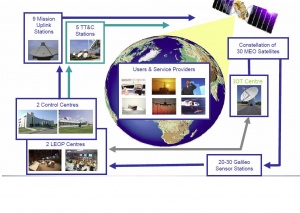
To ensure GALILEO services, a specific architecture is deployed, that consists of 30 satellites, to be deployed in a staggered approach, and the associated ground infrastructure.[1] The Galileo system is divided into three major segments: Space Segment, Ground Segment and User Segment.
Introduction
The Galileo infrastructure is composed of:
- a constellation of 30 satellites (including 6 spares) in Medium-Earth Orbit (MEO). Each satellite contains a navigation payload and a search and rescue transponder;
- a global network of Galileo Sensor Stations (GSS) providing coverage for clock synchronisation and orbit measurements;
- two Control Centres;
- a network of Mission Uplink stations;
- Telemetry, Tracking and Control (TT&C) stations.
- additional core infrastructure to service which support the provision of the Galileo service.
This infrastructure is organized in two segments, the Space Segment and the Ground Segment, to be complemented by the user receivers, which compose the User Segment.
GALILEO Space Segment
The main functions of the Galileo Space Segment are to generate and transmit code and carrier phase signals with a specific Galileo signal structure, and to store and retransmit the navigation message sent by the Control Segment. These transmissions are controlled by highly stable atomic clocks on board the satellites.
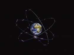
When Galileo is fully operational, there will be 30 satellites in Medium Earth Orbit (MEO) at an altitude of 23,222 kilometres. The satellites will occupy each of three orbital planes inclined at an angle of 56° with respect to the equator. The satellites will be spread evenly around each plane and will take about 14 hours to orbit the Earth. Each orbital plane includes 8 satellites uniformly distributed within the plane. The angular shift between satellites in two adjacent planes is 15º. One satellite in each plane will be a spare, on stand-by should any operational satellite fail. The full constellation includes 6 spare satellites, resulting a walker 24/3/1 constellation. These spare satellites can be activated and allocated to a given operational slot depending on maintenance or service evolution activities. The constellation geometry repetition period corresponding to the nominal orbital parameters is 10 days (corresponding to 17 orbital revolutions). This means that for any fixed Galileo user, the local satellite geometry at a given instant is repeated every 10 sideral days. In the following table are shown the Nominal Value of the different Reference Orbit Parameters:
| Reference Orbit Parameter | Nominal Value |
|---|---|
| Orbit semi-major axis, m | 29599801 |
| Orbit eccentricity | 1E-07 |
| Orbit inclination, deg | 56.0 |
| Argument of Perigee, deg | 0.0 |
Highly accurate atomic clocks are installed on these satellites. Each of the 30 satellites in the Galileo system has two of each type of clock on board, a rubidium and a hydrogen maser clock. The frequency is at around 6 GHz for the rubidium clock and at around 1.4 GHz for the hydrogen clock. The Galileo system uses the clock frequency as a very stable reference by which other units can generate the accurate signals that the Galileo satellites will broadcast. The broadcast signals also provide a reference by which the less stable user receiver clocks can continuously reset their time.
The satellites are deployed gradually according to the Galileo Program schedule.
GALILEO Ground Segment
The Galileo Ground Segment is the responsible for the proper operation of the GNSS system. It comprises two control centres, a global network of transmitting and receiving stations implementing monitoring and control functions and a series of service facilities which support the provision of the Galileo services[1].
The core of the GALILEO ground segment are the two Galileo Control Centres (GCC). Each control centre manages control functions supported by a Galileo Control Segment (GCS) and mission functions, supported by a dedicated Galileo Mission Segment (GMS). The GCS handles spacecraft housekeeping and constellation maintenance while the GMS handles navigation system control. The GCS and GMS interfaces the satellites with a worldwide ground station network implementing control and monitoring functions[1][2].
The Galileo Control Segment (GCS) is responsible for a large range of functions to support satellite constellation control and management of Galileo satellites. The scope of this functionality includes control and monitoring of the satellites and payload, planning and automation functions that allow safe and correct operations to take place, and the support of payload related operations by means of Telemetry Tracking and Control (TT&C) stations links. The GCS provides the telemetry, telecommand and control function for the whole Galileo satellite constellation. Its functional elements are deployed within the Galileo Control Centres (GCC) and the six globally distributed Telemetry Tracking and Control (TT&C) stations. To manage this, the GCS uses the TT&C stations to communicate with each satellite on a scheme combining regular, scheduled contacts, long-term test campaigns and contingency contacts.
The Galileo Mission Segment (GMS) consists of facilities deployed in the two Galileo Control Centres (GCCs) plus a series of Mission Up-Link Stations (ULS) and Galileo Sensor Stations (GSS) deployed at remote sites located around the world. The GMS is responsible for the determination and uplink of navigation data messages needed to provide the navigation and timing data. For this purpose, it uses a global network of Galileo Sensor Stations (GSS)[1][2] to monitor the navigation signals of all satellites on a continuous basis, through a comprehensive communications network using commercial satellites as well as cable connections in which each link is duplicated for redundancy.
GALILEO User Segment
The Galileo User Segment is composed by Galileo receivers. Their main function is to receive Galileo signals, determine pseudoranges (and other observables), and solve the navigation equations in order to obtain their coordinates and provide a very accurate time.
Notes
References
| GALILEO | |
|---|---|
| Title | Galileo Architecture |
| Edited by | GMV |
| Level | Basic |
| Year of Publication | 2011 |


