If you wish to contribute or participate in the discussions about articles you are invited to contact the Editor
MSAS Space Segment
| MSAS | |
|---|---|
| Title | MSAS Space Segment |
| Edited by | GMV |
| Level | Basic |
| Year of Publication | 2011 |
The MTSAT Satellite Augmentation System (MSAS) is the Japanese Satellite Based Augmentation System (SBAS) System:[1] a GPS Augmentation system with the goal of improving its accuracy, integrity, and availability.
First tests were accomplished successfully, and MSAS system for aviation use was declared operational in September 27, 2007,[2][3][4] providing a service of horizontal guidance for En-route through Non-Precision Approach.[1][2][5]
The SBAS signal used to be transmitted from MTSAT (Multi-functional Transport Satellites) operated by the Ministry of Land, Infrastructure, Transport and Tourism (MLIT). The SBAS signal that is made by MLIT is now transmitted from the QZS-3 GEO satellite using the QZSS SBAS transmission service since April 2020.[6]
MSAS Space Segment
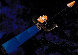
The space segment originally consisted of two geosynchronous communication satellites (GEO): the Multifunctional Transport Satellites (MTSAT), with navigation payloads which broadcasted the correction messages generated by the Master Control Stations for reception by the users.[5] These two satellites were not only devoted to navigation, but also to meteorological/weather purposes.
MTSAT were owned and operated by the Japanese Ministry of Land, Infrastructure and Transport and the Japan Meteorological Agency (JMA),[7] and provide coverage for the hemisphere centered on 140° East (including Japan and Australia, the main users of the MTSAT images). Besides being the Space Segment of the Japanese MSAS Augmentation system, the MTSAT satellites provided imagery in five wavelength bands for weather functions.
MTSAT-1R (also known as Himawari 6) was successfully launched on a H-IIA on February 26, 2005.[8] It was built by Space Systems/Loral. MTSAT-2 (also known as Himawari 7) was built by Mitsubishi and successfully put in orbit on February 18, 2006.[8] Their lifespan was planned of five years.[8][9] Both satellites, MTSAT-1R and MTSAT-2, were controlled by Kobe MCS station and Hitachiota MCS, respectively.[5] The main characteristics of MTSAT satellites are shown in next table (table taken from MSAS article in Wikipedia):[10]
| Satellite Name & Details | NMEA / PRN | Location |
|---|---|---|
| MTSAT-1R | NMEA #42 / PRN #129 | 140°E |
| MTSAT-2 | NMEA #50 / PRN #137 | 145°E |
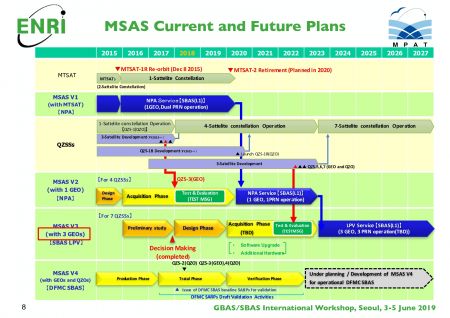
MSAS V2 (2020)
MTSAT-2 was replaced by the weather-only Himawari 8 in 2015 and MTSAT-1R was decommissioned later that year, due to fuel limitations.
MTSAT-2 remained operational in its SBAS functions until 2020 when the geostationary QZS-3 satellite, launched in august 2017, assumed the SBAS transmission service, thus starting the MSAS V2 phase.
The QZS-3 satellite or Michibiki 3, was built by Mitsubishi Electric, based on the DS2000 bus. It is placed at 127º East and its improved antenna allows it to transmit two signals (dual-PRN operation). It was the first satellite to transmit an L1Sb SBAS signal. [11] [12]
Future Plans
Future plans for the MSAS include two additional QZSS-GEO satellites (QZS-6 and QZS-7) for MSAS V3 (2023(TBD)) as well as combined GEO and IGSO satellites operation and DFMC (Dual-Frequency Multi-Constellation) for the future MSAS V4. [11]

Notes
References
- ^ a b MSAS Current Status, Japan Civil Aviation Bureau, Second Meeting of the International Committee on Global Navigation Satellite Systems (ICG) organized by the International Space Research Organization, Bangalore, India , 5 - 7 September 2007
- ^ a b QZSS / MSAS Status, CGSIC –47th Meeting ,Fort Worth, Texas September25, 2007, Satoshi KOGURE, Japan Aerospace Exploration Agency, QZSS Project Team
- ^ Eric Gakstatter, Perspectives - Late April 2008, GPSworld, April 15, 2008
- ^ Multi-functional Satellite Augmentation System in Wikipedia
- ^ a b c Overview of MSAS, Presentation for ICG-3, 2008
- ^ SBAS Transmission Service
- ^ MTSAT and its System, Satellite Program Division, Japan Meteorological Agency
- ^ a b c MTSAT in Wikipedia
- ^ 12 Major characteristics of MTSAT series, Japan Meteorological Agency
- ^ MSAS in Wikipedia
- ^ a b c "GBAS/SBAS Implementation Perspective - Japan", GBAS/SBAS International Workshop, Seoul, 3-5 June 2019
- ^ "Innovation: QZS-3 and QZS-4 join the Quasi-Zenith Satellite System", GPSworld, February 9, 2018

