If you wish to contribute or participate in the discussions about articles you are invited to contact the Editor
MSAS Space Segment
| MSAS | |
|---|---|
| Title | MSAS Space Segment |
| Edited by | GMV A.D. |
| Level | Basic |
| Year of Publication | 2011 |
The MTSAT Satellite Augmentation System (MSAS) is the Japanese Satellite Based Augmentation System (SBAS) System:[1] a GPS Augmentation system with the goal of improving its accuracy, integrity, and availability, and that uses the Multifunctional Transport Satellites (MTSAT) owned and operated by the Japanese Ministry of Land, Infrastructure and Transport and the Japan Meteorological Agency (JMA).[2]
First tests were accomplished successfully, and MSAS system for aviation use was declared operational in September 27, 2007,[3][4][5] providing a service of horizontal guidance for En-route through Non-Precision Approach.[1][3][6]
MSAS Space Segment
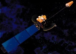
The space segment consists of two geosynchronous communication satellites (GEO): the Multifunctional Transport Satellites (MTSAT), with navigation payloads which broadcast the correction messages generated by the Master Control Stations for reception by the users.[6] These two satellites are not only devoted to navigation, but also to meteorological/weather purposes.
MTSAT are owned and operated by the Japanese Ministry of Land, Infrastructure and Transport and the Japan Meteorological Agency (JMA),[7] and provide coverage for the hemisphere centred on 140° East (including Japan and Australia, the main users of the MTSAT images). Besides being the Space Segment of the Japanese MSAS Augmentation system, the MTSAT satellites provide imagery in five wavelength bands for weather functions.
MTSAT-1R (also known as Himawari 6) was successfully launched on a H-IIA on February 26, 2005.[2] It was built by Space Systems/Loral. MTSAT-2 (also known as Himawari 7) was built by Mitsubishi and successfully put in orbit on February 18, 2006.[2] Their lifespan is planned of five years.[2][8] Both satellites, MTSAT-1R and MTSAT-2, are controlled by Kobe MCS station and Hitachiota MCS, respectively.[6] The main characteristics of MTSAT satellites are shown in next table (table taken from MSAS article in Wikipedia):[5]
| Satellite Name & Details | NMEA / PRN | Location |
|---|---|---|
| MTSAT-1R | NMEA #42 / PRN #129 | 140°E |
| MTSAT-2 | NMEA #50 / PRN #137 | 145°E |
It is noted that the satellite MTSAT-1R has already exceeded its foreseen operational lifespan; according to the Japan Meteorological Agency, the status of this satellite is Observation Standby.[9]
Notes
References
- ^ a b MSAS Current Status, Japan Civil Aviation Bureau, Second Meeting of the International Committee on Global Navigation Satellite Systems (ICG) organized by the International Space Research Organization, Bangalore, India , 5 - 7 September 2007
- ^ a b c d MTSAT in Wikipedia
- ^ a b QZSS / MSAS Status, CGSIC –47th Meeting ,Fort Worth, Texas September25, 2007, Satoshi KOGURE, Japan Aerospace Exploration Agency, QZSS Project Team
- ^ Eric Gakstatter, Perspectives - Late April 2008, GPSworld, April 15, 2008
- ^ a b MSAS in Wikipedia
- ^ a b c Overview of MSAS, Presentation for ICG-3, 2008
- ^ MTSAT and its System, Satellite Program Division, Japan Meteorological Agency
- ^ Major characteristics of MTSAT series, Japan Meteorological Agency
- ^ Meteorological Satellite MTSAT series, in Japan Meteorological Agency web site

