If you wish to contribute or participate in the discussions about articles you are invited to contact the Editor
Galileo Architecture: Difference between revisions
No edit summary |
No edit summary |
||
| Line 14: | Line 14: | ||
==Introduction== | ==Introduction== | ||
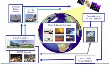
[[File:GalileoFOCArchitecture.JPG|350px|Galileo Architecture|thumb]] | [[File:GalileoFOCArchitecture.JPG|350px|Galileo Architecture|thumb]] | ||
The Galileo full infrastructure will be composed of: | |||
The Galileo full infrastructure, the core of the system, will be composed of: | |||
* A constellation of 30 satellites in Medium-Earth Orbit (MEO). Each satellite will contain a navigation payload and a search and rescue transponder; | * A constellation of 30 satellites in Medium-Earth Orbit (MEO). Each satellite will contain a navigation payload and a search and rescue transponder; | ||
* around 30 sensor stations; | * around 30 sensor stations; | ||
| Line 20: | Line 21: | ||
* 9 Mission Uplink stations; | * 9 Mission Uplink stations; | ||
* 5 TT&C stations. | * 5 TT&C stations. | ||
"Galileo Regional Component": This component complements the global services of Galileo, which involves the delivery of worldwide integrity12 for Galileo satellites. The Galileo Regional Component includes the EGNOS system, providing integrity and deferential corrections for GPS and GLONASS13 through geostationary satellites, as well as several External Region Integrity Systems (ERIS), implemented and operated by organizations, countries or groups of countries outside of Europe to obtain integrity services independent of Galileo. | |||
In this way, different integrity-monitoring stations collect data and send them to a Processing Centre to compute regional corrections and integrity data. The regional integrity data is uplinked to the Galileo satellites and broadcast to the service area users via a dedicated channel. A maximum number of five regions will be covered due to the limitations in the capacity of the message. | |||
"Galileo Local component": This component allows enhanced accuracy, availability and integrity in local areas as airports, maritime harbours, etc., with more demanding requirements than those available from the global or regional components (e.g., integrity). These special services are met through the use of local augmentation elements. | |||
Revision as of 09:12, 11 April 2011
| GALILEO | |
|---|---|
| Title | Galileo Architecture |
| Author(s) | GMV |
| Level | Basic |
| Year of Publication | 2011 |
The GALILEO System will comprise global, regional and local components. The global component is the core of the system, comprising the satellites and the required ground segment. To ensure GALILEO services, a specific architecture is deployed, that will consist of 30 satellites, to be deployed in a staggered approach, and the associated ground infrastructure.[1]
The Galileo system is divided into three major segments: Space Segment, Control Segment and User Segment.
Introduction
The Galileo full infrastructure, the core of the system, will be composed of:
- A constellation of 30 satellites in Medium-Earth Orbit (MEO). Each satellite will contain a navigation payload and a search and rescue transponder;
- around 30 sensor stations;
- 2 control centres & 2 LEOP Centers;
- 9 Mission Uplink stations;
- 5 TT&C stations.
"Galileo Regional Component": This component complements the global services of Galileo, which involves the delivery of worldwide integrity12 for Galileo satellites. The Galileo Regional Component includes the EGNOS system, providing integrity and deferential corrections for GPS and GLONASS13 through geostationary satellites, as well as several External Region Integrity Systems (ERIS), implemented and operated by organizations, countries or groups of countries outside of Europe to obtain integrity services independent of Galileo.
In this way, different integrity-monitoring stations collect data and send them to a Processing Centre to compute regional corrections and integrity data. The regional integrity data is uplinked to the Galileo satellites and broadcast to the service area users via a dedicated channel. A maximum number of five regions will be covered due to the limitations in the capacity of the message.
"Galileo Local component": This component allows enhanced accuracy, availability and integrity in local areas as airports, maritime harbours, etc., with more demanding requirements than those available from the global or regional components (e.g., integrity). These special services are met through the use of local augmentation elements.
GALILEO Space Segment
The main functions of the Galileo Space Segment are to generate and transmit code and carrier phase signals with a specific Galileo signal structure, and to store and retransmit the navigation message sent by the Control Segment. These transmissions are controlled by highly stable atomic clocks on board the satellites.
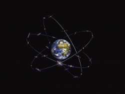
When Galileo is fully operational, there will be 30 satellites in Medium Earth Orbit (MEO) at an altitude of 23,222 kilometres. The satellites will occupy each of three orbital planes inclined at an angle of 56° to the equator. The satellites will be spread evenly around each plane and will take about 14 hours to orbit the Earth. One satellite in each plane will be a spare; on stand-by should any operational satellite fail.[1]
Based on the award of the contracts for the first order of satellites, the launch services, the system support services and the operations, the European Commission announced the Initial Operational Capability (IOC) with three initial services to be provided in 2014/2015: an initial Open Service, an initial Public Regulated Service and an initial Search and Rescue Service.[2] At this stage, accuracy and availability will not yet have reached their optimum level, the Safety-of-Life Service and the Commercial Service will be tested and will be provided as the system reaches full operational capability with the 30 satellites.[3]
Highly accurate atomic clocks are installed on these satellites.Each of the 30 satellites in the Galileo system will have two of each type of clock on board, a rubidium and a hydrogen maser clock. The frequency is at around 6 GHz for the rubidium clock and at around 1.4 GHz for the hydrogen clock. The Galileo system uses the clock frequency as a very stable reference by which other units can generate the accurate signals that the Galileo satellites will broadcast. The broadcast signals will also provide a reference by which the less stable user receiver clocks can continuously reset their time.
GALILEO Ground Segment
The Galileo Control Segment (also referred to as Ground Segment) is the responsible for the proper operation of the GNSS system. Its basic functions are:
- To control and maintain the status and configuration of the satellite constellation.
- To predict ephemeris and satellite clock evolution.
- To keep the corresponding GNSS time scale (through atomic clocks).
- To update the navigation messages for all the satellites.
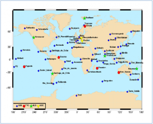
The Galileo Ground Segment constitutes the major system element controlling the entire constellation, the navigation system facilities and the dissemination services. It is composed of two Ground Control Centres (GCC), five Telemetry, Tracking and Control (TT&C) stations, nine Mission Uplink Stations (ULS), and about fourteen Galileo Sensor Stations (GSS). The Ground Control Segment (GCS) as the responsible for satellite constellation control and management of Galileo satellites, it provides the telemetry, telecommand and control function for the whole Galileo satellite constellation. Its functional elements are deployed within the GCCs and the five globally distributed TT&C stations.
GALILEO Regional Component
GALILEO User Segment
The Galileo user segment is composed by Galileo receivers. Their main function is to receive Galileo signals, determine pseudoranges (and other observables), and solve the navigation equations in order to obtain their coordinates and provide a very accurate time.
Notes
References
- ^ a b ESA Galileo web page
- ^ Commission awards major contracts to make Galileo operational early 2014, IP/10/7, Brussels, 7 January 2010.
- ^ Mid-term review of the European satellite radio navigation programmes


