If you wish to contribute or participate in the discussions about articles you are invited to contact the Editor
WAAS Architecture: Difference between revisions
Carlos.Lopez (talk | contribs) No edit summary |
m (Included editor logo.) |
||
| Line 4: | Line 4: | ||
|Level=Basic | |Level=Basic | ||
|YearOfPublication=2011 | |YearOfPublication=2011 | ||
|Logo=GMV | |||
|Title={{PAGENAME}} | |Title={{PAGENAME}} | ||
}} | }} | ||
Revision as of 17:19, 18 September 2014
| WAAS | |
|---|---|
| Title | WAAS Architecture |
| Edited by | GMV |
| Level | Basic |
| Year of Publication | 2011 |
The Wide Area Augmentation System (WAAS) is the United States Satellite Based Augmentation System. The programme, started in 1992, is being carried out by the Federal Aviation Agency (FAA)[1] and is specially developed for the civil aviation community.[2] The system, which was declared operational in late 2003,[3] currently supports thousands of aircraft instrument approaches in more than one thousand airports in USA and Canada.[4] WAAS service area includes CONUS, Alaska, Canada and Mexico.[5] The WAAS programme is continuously in evolution; two development phases have been already covered, a third is in progress, and there are plans to improve the capability of the system in parallel with the evolution of the SBAS standards towards a dual-frequency augmentation service.[6]
WAAS Architecture
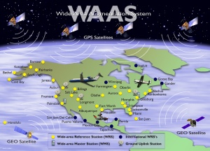
WAAS works by processing GPS data collected by a network of reference stations to generate the SBAS message which is uploaded to the GEO satellites. The GEO satellites broadcast this information to the user receivers, which compute the aircraft positioning and inform on potential alert messages.[7]
The main layers of WAAS architecture are:
- WAAS Ground Segment: The WAAS ground segment encompasses reference stations (Wide-area Reference Stations, WRS), master stations (WAAS Master Stations, WMS), uplink stations (Ground Uplink Stations, GUS), and operational centers. The Wide-area Reference Stations, which are positioned with high precision, collect the signals transmitted by the GPS satellites and send this information to the WMS. The WMS processes all the data to build the augmentation message that will contain corrections to the GPS data and confidence limits to such corrections. The message generated by the WMS is uplinked from the Ground Uplink Stations to the WAAS GEO satellites (WAAS Space Segment), which will broadcast it across the GEO footprint for the benefit of the WAAS users (WAAS User Segment).[7]
- WAAS Space Segment: The space segment is composed of multiple geosynchronous communication satellites (GEO) with navigation payloads that broadcast the WAAS augmentation messages generated by the WMS to the User segment.
- WAAS User Segment: The user segment is usually any aircraft with approved WAAS avionics, i.e. with a WAAS-enabled GPS receiver that used the WAAS corrections from the Space segment. The WAAS user equipment shall be compliant (certified) against several standards, i.e. RTCA MOPS DO 229 (see article SBAS Standards).
Notes
References
- ^ Navigation Services - History - Satellite Navigation, FAA.
- ^ Navigation Services - Wide Area Augmentation System (WAAS), FAA.
- ^ Wide Area Differential GPS (WADGPS), Stanford University
- ^ GNSS - GPS/WAAS Approaches, Federal Aviation Agency (FAA).
- ^ WAAS Service Expanded into Canada and Mexico, September 28, 2007, Federal Aviation Agency (FAA).
- ^ SatNav News, Vol. 33, March 2008, Federal Aviation Agency (FAA).
- ^ a b FAA WAAS: How it works

