If you wish to contribute or participate in the discussions about articles you are invited to contact the Editor
Klobuchar Ionospheric Model: Difference between revisions
Carlos.Lopez (talk | contribs) No edit summary |
Gema.Cueto (talk | contribs) No edit summary |
||
| (15 intermediate revisions by 3 users not shown) | |||
| Line 1: | Line 1: | ||
{{Article Infobox2 | {{Article Infobox2 | ||
|Category=Fundamentals | |Category=Fundamentals | ||
|Authors=J. Sanz Subirana, J.M. Juan Zornoza and M. Hernández-Pajares, Technical University of Catalonia, Spain. | |||
|Level=Advanced | |||
|YearOfPublication=2011 | |||
|Title={{PAGENAME}} | |Title={{PAGENAME}} | ||
}} | }} | ||
GPS satellites broadcast the parameters of the Klobuchar ionospheric model for single frequency users. The Klobuchar model was designed to minimise user computational complexity and user computer storage as far as to keep a minimum number of coefficients to transmit on satellite-user link. | GPS satellites broadcast the parameters of the Klobuchar ionospheric model for single frequency users. The Klobuchar model was designed to minimise user computational complexity and user computer storage as far as to keep a minimum number of coefficients to transmit on satellite-user link. | ||
This broadcast model is based on an empirical approach <ref name="Klobuchar"> [Klobuchar, 1987] Klobuchar, J., 1987. Ionospheric Time-Delay Algorithms for Single-Frequency GPS Users. IEEE Transactions on Aerospace and Electronic Systems (3), pp. 325 | This broadcast model is based on an empirical approach [Klobuchar, 1987] <ref name="Klobuchar"> [Klobuchar, 1987] Klobuchar, J., 1987. Ionospheric Time-Delay Algorithms for Single-Frequency GPS Users. IEEE Transactions on Aerospace and Electronic Systems (3), pp. 325-331.</ref> and is estimated to reduce about the 50% RMS ionospheric range error worldwide. It is assumed that the electron content is concentrated in a thin layer at <math>350</math> kilometres in height. Thence, the slant delay is computed from the vertical delay at the Ionospheric Pierce Point (IPP) <ref group="footnotes">That is the intersection of the ray with the ionospheric layer at <math>350</math> kilometres in height.</ref> multiplying by a obliquity factor, i.e., the mapping function, see figure 1 and equation (9). | ||
| Line 16: | Line 16: | ||
'''''Klobuchar Algorithm equations''''' | '''''Klobuchar Algorithm equations''''' | ||
The Klobuchar algorithm to run in a single frequency receiver is provided as follows (from <ref name="Klobuchar"/>): | The Klobuchar algorithm to run in a single frequency receiver is provided as follows (from [Klobuchar, 1987]<ref name="Klobuchar"/>): | ||
Given the user approximate geodetic latitude <math>\phi_u</math>, longitude <math>\lambda_u</math>, elevation angle <math>E</math> and azimuth <math>A</math> of the observed satellite and the coefficients <math>\alpha_n</math> and <math>\beta_n</math> broadcasted in the GPS satellite navigation message: | Given the user approximate geodetic latitude <math>\displaystyle \phi_u</math>, longitude <math>\displaystyle \lambda_u</math>, elevation angle <math>\displaystyle E</math> and azimuth <math>\displaystyle A</math> of the observed satellite and the coefficients <math>\displaystyle \alpha_n</math> and <math>\displaystyle \beta_n</math> broadcasted in the GPS satellite navigation message: | ||
:'''1. Calculate the earth-centred angle (elevation <math>E</math> in semicircles).''' | :'''1. Calculate the earth-centred angle (elevation <math>\displaystyle E</math> in semicircles).''' | ||
::<math> | ::<math> | ||
\psi =\frac{0.0137}{E+0.11}-0.022 \qquad\mbox{(semicircles)} | \psi =\frac{0.0137}{E+0.11}-0.022 \qquad\mbox{(semicircles)} | ||
\qquad\mbox{(1)}</math> | \qquad\mbox{(1)}</math> | ||
:Note: All values expressed in semicircles (such as latitudes and longitudes) must be converted to radians before applying trigonometric functions. This conversion is crucial to avoid slight inaccuracies in the computed results. The conversion from semicircles to radians is performed by multiplying the value in semicircles by <math>\pi</math>. | |||
| Line 34: | Line 36: | ||
:If <math>\ | :If <math>\displaystyle \Phi_I> +0.416</math> the <math>\displaystyle \Phi_I=+0.416</math>. If <math>\Phi_I< -0.416</math> the <math>\Phi_I=-0.416</math>. | ||
| Line 42: | Line 44: | ||
\lambda_I=\lambda_u+\frac{\psi \sin A}{\cos \phi_I} \qquad\mbox{(semicircles)} \qquad\mbox{(3)}</math> | \lambda_I=\lambda_u+\frac{\psi \sin A}{\cos \phi_I} \qquad\mbox{(semicircles)} \qquad\mbox{(3)}</math> | ||
:Note: The input longitude values are in the range [0, 2π] (semicircles), not in the common range of [-π, π] (radians). | |||
:'''4. Find the geomagnetic latitude of the IPP.''' | :'''4. Find the geomagnetic latitude of the IPP.''' | ||
| Line 49: | Line 52: | ||
:'''5. Find the local time | :'''5. Find the local time '''t' ''' (in seconds) at the ionospheric pierce point.''' | ||
t | |||
: | :<math> | ||
t' = (43200 \cdot \lambda + t_{\text{GPS}}) \mod 86400 | |||
</math> | |||
: | :where: | ||
:* <math>t_{\text{GPS}}</math> is the '''GPS time in seconds of the week''' (0 to 604800 s). | |||
:* <math>\lambda</math> is the geodetic latitude of the ionospheric pierce point (in semicircles). | |||
:* The '''modulo operation ensures''' that <math>t'</math> remains within a 24-hour cycle, which is required for the Klobuchar model to correctly compute the ionospheric delay. | |||
| Line 91: | Line 95: | ||
::<math> | ::<math> | ||
I_ | I_{_{L1_{GPS}}}=\left \{ | ||
\begin{array}{ll} | \begin{array}{ll} | ||
\left [5\cdot 10^{-9}+ \sum_{n=0}^{3}{\alpha_n \phi_m^n}\cdot \left ( 1- \frac{X_I^2}{2}+\frac{X_I^4}{24} \right) \right ] \cdot F &; |X_I|\leq 1.57\\[0.5cm] | \left [5\cdot 10^{-9}+ \sum_{n=0}^{3}{\alpha_n \phi_m^n}\cdot \left ( 1- \frac{X_I^2}{2}+\frac{X_I^4}{24} \right) \right ] \cdot F &; |X_I|\leq 1.57\\[0.5cm] | ||
| Line 97: | Line 101: | ||
\end{array} | \end{array} | ||
\right . | \right . | ||
\qquad\mbox{(10)}</math> | \qquad\mbox{(10)} | ||
</math> | |||
:The delay <math>I_{_{L1_{GPS}}}</math> is given in seconds and it is referred to the GPS L1 frequency. | :The delay <math>I_{_{L1_{GPS}}}</math> is given in seconds and it is referred to the GPS L1 frequency. | ||
: | :To convert this delay into range units (meters), multiply the ionospheric delay by the speed of light \( c \): | ||
::<math> | ::<math> | ||
\ | \Delta R = c \cdot I_{L1, GPS} | ||
</math> | |||
:Where: | |||
::* <math>\Delta R</math> is the ionospheric delay in meters. | |||
::* <math>c = 299,792,458</math> m/s is the speed of light in vacuum. | |||
:This conversion is essential as the delay is initially calculated in time units (seconds) and must be expressed in distance units (meters) to be used in range calculations. | |||
| Line 118: | Line 125: | ||
Figure 2 is a layout of the Klobuchar model algorithm, showing that the vertical delays are based on a constant value at night time and a half-cosine function in daytime, which amplitude and period | Figure 2 is a layout of the Klobuchar model algorithm, showing that the vertical delays are based on a constant value at night time and a half-cosine function in daytime, which amplitude and period are given as a function of the eight parameters (<math>\alpha_i,\, \beta_i,\,i=0,\dots,3</math>) broadcast in the GPS navigation message. A map with the geographical variation of the vertical delay is also depicted in this figure. | ||
| Line 147: | Line 154: | ||
[[Category:Fundamentals]] | [[Category:Fundamentals]] | ||
[[Category:GNSS Measurements Modelling]] | |||
Latest revision as of 07:44, 24 April 2025
| Fundamentals | |
|---|---|
| Title | Klobuchar Ionospheric Model |
| Author(s) | J. Sanz Subirana, J.M. Juan Zornoza and M. Hernández-Pajares, Technical University of Catalonia, Spain. |
| Level | Advanced |
| Year of Publication | 2011 |
GPS satellites broadcast the parameters of the Klobuchar ionospheric model for single frequency users. The Klobuchar model was designed to minimise user computational complexity and user computer storage as far as to keep a minimum number of coefficients to transmit on satellite-user link.
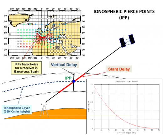
This broadcast model is based on an empirical approach [Klobuchar, 1987] [1] and is estimated to reduce about the 50% RMS ionospheric range error worldwide. It is assumed that the electron content is concentrated in a thin layer at [math]\displaystyle{ 350 }[/math] kilometres in height. Thence, the slant delay is computed from the vertical delay at the Ionospheric Pierce Point (IPP) [footnotes 1] multiplying by a obliquity factor, i.e., the mapping function, see figure 1 and equation (9).
Klobuchar Algorithm equations
The Klobuchar algorithm to run in a single frequency receiver is provided as follows (from [Klobuchar, 1987][1]):
Given the user approximate geodetic latitude [math]\displaystyle{ \displaystyle \phi_u }[/math], longitude [math]\displaystyle{ \displaystyle \lambda_u }[/math], elevation angle [math]\displaystyle{ \displaystyle E }[/math] and azimuth [math]\displaystyle{ \displaystyle A }[/math] of the observed satellite and the coefficients [math]\displaystyle{ \displaystyle \alpha_n }[/math] and [math]\displaystyle{ \displaystyle \beta_n }[/math] broadcasted in the GPS satellite navigation message:
- 1. Calculate the earth-centred angle (elevation [math]\displaystyle{ \displaystyle E }[/math] in semicircles).
- [math]\displaystyle{ \psi =\frac{0.0137}{E+0.11}-0.022 \qquad\mbox{(semicircles)} \qquad\mbox{(1)} }[/math]
- Note: All values expressed in semicircles (such as latitudes and longitudes) must be converted to radians before applying trigonometric functions. This conversion is crucial to avoid slight inaccuracies in the computed results. The conversion from semicircles to radians is performed by multiplying the value in semicircles by [math]\displaystyle{ \pi }[/math].
- 2. Compute the latitude of the Ionospheric Pierce Point (IPP)[footnotes 2].
- [math]\displaystyle{ \phi_I=\phi_u+\psi \cos A \qquad\mbox{(semicircles)} \qquad\mbox{(2)} }[/math]
- If [math]\displaystyle{ \displaystyle \Phi_I\gt +0.416 }[/math] the [math]\displaystyle{ \displaystyle \Phi_I=+0.416 }[/math]. If [math]\displaystyle{ \Phi_I\lt -0.416 }[/math] the [math]\displaystyle{ \Phi_I=-0.416 }[/math].
- 3. Compute the longitude of the IPP.
- [math]\displaystyle{ \lambda_I=\lambda_u+\frac{\psi \sin A}{\cos \phi_I} \qquad\mbox{(semicircles)} \qquad\mbox{(3)} }[/math]
- Note: The input longitude values are in the range [0, 2π] (semicircles), not in the common range of [-π, π] (radians).
- 4. Find the geomagnetic latitude of the IPP.
- [math]\displaystyle{ \phi_m=\phi_I+0.064 \, \cos (\lambda_I-1.617) \qquad\mbox{(semicircles)} \qquad\mbox{(4)} }[/math]
- 5. Find the local time t' (in seconds) at the ionospheric pierce point.
- [math]\displaystyle{ t' = (43200 \cdot \lambda + t_{\text{GPS}}) \mod 86400 }[/math]
- where:
- [math]\displaystyle{ t_{\text{GPS}} }[/math] is the GPS time in seconds of the week (0 to 604800 s).
- [math]\displaystyle{ \lambda }[/math] is the geodetic latitude of the ionospheric pierce point (in semicircles).
- The modulo operation ensures that [math]\displaystyle{ t' }[/math] remains within a 24-hour cycle, which is required for the Klobuchar model to correctly compute the ionospheric delay.
- 6. Compute the amplitude of ionospheric delay.
- [math]\displaystyle{ A_I=\displaystyle\sum_{n=0}^{3}{\alpha_n \phi_m^n} \qquad\mbox{(seconds)} \qquad\mbox{(6)} }[/math]
- if [math]\displaystyle{ A_I\lt 0 }[/math], thence [math]\displaystyle{ A_I=0 }[/math].
- 7. Compute the period of ionospheric delay.
- [math]\displaystyle{ P_I=\displaystyle\sum_{n=0}^{3}{\beta_n \phi_m^n}\qquad\mbox{(seconds)} \qquad\mbox{(7)} }[/math]
- if [math]\displaystyle{ P_I\lt 72\,000 }[/math], thence [math]\displaystyle{ P_I=72\,000 }[/math].
- 8. Compute the phase of ionospheric delay.
- [math]\displaystyle{ X_I=\displaystyle \frac{\displaystyle 2\pi(t-50\,400)}{P_I} \qquad\mbox{(radians)} \qquad\mbox{(8)} }[/math]
- 9. Compute the slant factor (elevation [math]\displaystyle{ E }[/math] in semicircles).
- [math]\displaystyle{ F=1.0+16.0\,(0.53-E)^3 \qquad\mbox{(9)} }[/math]
- 10. Compute the ionospheric time delay.
- [math]\displaystyle{ I_{_{L1_{GPS}}}=\left \{ \begin{array}{ll} \left [5\cdot 10^{-9}+ \sum_{n=0}^{3}{\alpha_n \phi_m^n}\cdot \left ( 1- \frac{X_I^2}{2}+\frac{X_I^4}{24} \right) \right ] \cdot F &; |X_I|\leq 1.57\\[0.5cm] 5\cdot 10^{-9}\cdot F &; |X_I|\geq 1.57 \end{array} \right . \qquad\mbox{(10)} }[/math]
- The delay [math]\displaystyle{ I_{_{L1_{GPS}}} }[/math] is given in seconds and it is referred to the GPS L1 frequency.
- To convert this delay into range units (meters), multiply the ionospheric delay by the speed of light \( c \):
- [math]\displaystyle{ \Delta R = c \cdot I_{L1, GPS} }[/math]
- Where:
- [math]\displaystyle{ \Delta R }[/math] is the ionospheric delay in meters.
- [math]\displaystyle{ c = 299,792,458 }[/math] m/s is the speed of light in vacuum.
- This conversion is essential as the delay is initially calculated in time units (seconds) and must be expressed in distance units (meters) to be used in range calculations.
Although this algorithm is provided to estimate the ionospheric delay in the GPS L1 frequency signal, it can be also used to estimate the ionospheric time delay in the GPS L2 frequency signal or for the GLONASS and Galileo signals, as well. Indeed, taking into account that the ionospheric delay is inversely proportional to the square of the signal frequency, the delay for any GNSS signal transmitted on frequency [math]\displaystyle{ f }[/math] is given by:
- [math]\displaystyle{ I_f= \left ( \frac{f_{_{L1_{GPS}}}}{f} \right )^2\,I_{_{L1_{GPS}}} \qquad\mbox{(12)} }[/math]
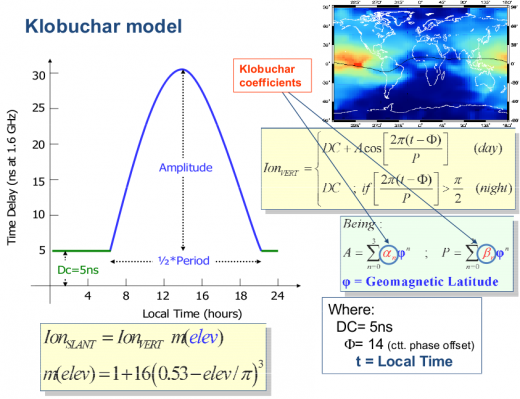
Figure 2 is a layout of the Klobuchar model algorithm, showing that the vertical delays are based on a constant value at night time and a half-cosine function in daytime, which amplitude and period are given as a function of the eight parameters ([math]\displaystyle{ \alpha_i,\, \beta_i,\,i=0,\dots,3 }[/math]) broadcast in the GPS navigation message. A map with the geographical variation of the vertical delay is also depicted in this figure.
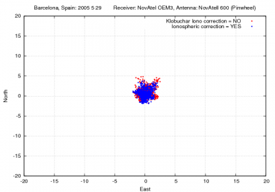
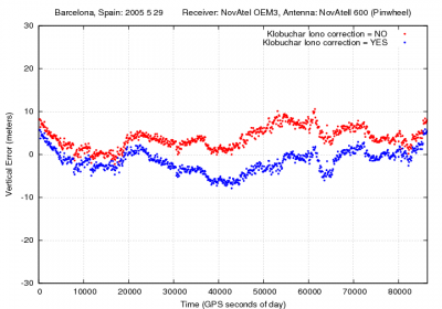
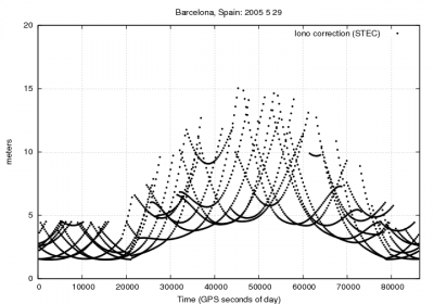
Figure 3 illustrates with an example the values of the GPS delays from the Klobuchar model and shows the effect of neglecting such delays in single point positioning for the horizontal and vertical error components.
Figure 3: Ionospheric correction: Range and position domain effect First row shows the horizontal (left) and vertical (right) positioning error using (blue) or not using (red) the Klobuchar ionospheric correction defined in 1. The variation in range is shown in the second row at left
Notes

