If you wish to contribute or participate in the discussions about articles you are invited to contact the Editor
Galileo General Introduction: Difference between revisions
Sort criterium for listing on category page |
Gema.Cueto (talk | contribs) m Updated reference ICD/SDD links |
||
| (39 intermediate revisions by 4 users not shown) | |||
| Line 3: | Line 3: | ||
|Editors=GMV | |Editors=GMV | ||
|Level=Basic | |Level=Basic | ||
|YearOfPublication= | |YearOfPublication=2025 | ||
|Logo=GMV | |||
|Title={{PAGENAME}} | |Title={{PAGENAME}} | ||
}} | }} | ||
Galileo is Europe’s own global navigation satellite system, providing a highly accurate, guaranteed global positioning service under civilian control. It is inter-operable with [[GPS General Introduction|GPS]] | Galileo is Europe’s own global navigation satellite system, providing a highly accurate, guaranteed global positioning service under civilian control. It is inter-operable with others GNSS such as [[GPS General Introduction|GPS]], [[GLONASS General Introduction|GLONASS]] and [[BeiDou General Introduction|BEIDOU]]. Galileo receivers compute their position in the [[GALILEO Reference Frame|Galileo Reference System]] using satellite technology and based on [[An intuitive approach to the GNSS positioning|trilateration principles]]. | ||
The Galileo system started its initial services on December 15th, 2016, <ref>[http://europa.eu/rapid/press-release_IP-16-4366_en.htm Galileo goes live!]</ref> and continues to evolve with infrastructure deployment towards Full Operational Capability (FOC). | |||
Galileo system is in constant improvement, leading to a [https://www.esa.int/Applications/Satellite_navigation/Galileo_Second_Generation_enters_full_development_phase Galileo Second Generation (G2)] satellites which will revolutionize the Galileo fleet. G2 satellites are much larger, with significant changes with respect to the first version like the use of electric propulsion, an enhanced antenna with larger radiation area, inter-satellite links between the satellites which will reduce their dependency on the availability of ground installations and the addition of two atomic clocks. Moreover, G2’s fully digital payloads are being designed to be easily reconfigured in orbit, enabling them to actively respond to the evolving needs of users with novel signals and services.<ref>[https://www.esa.int/ESA_Multimedia/Images/2021/05/Galileo_Second_Generation Galileo Second Generation]</ref> | |||
==Introduction== | ==Introduction== | ||
[[File:Galileo_Art.png|400px|Galileo Constellation (artistic interpretation)|left|thumb]] Galileo is Europe's Global Navigation Satellite System (GNSS), offering highly accurate, civilian-controlled positioning, navigation, and timing services. Galileo is designed to be fully interoperable with GPS, GLONASS, and BeiDou, providing enhanced reliability and precision. The system operates with a constellation of satellites in Medium Earth Orbit (MEO) at an altitude of 23,222 km, ensuring continuous global coverage. From most locations, six to eight satellites will always be visible <ref>[https://www.euspa.europa.eu/eu-space-programme/galileo/faqs/how-many-satellites-will-galileo-have EUSPA FAQs]</ref>, reaching high values of availability even under challenging conditions. Moreover, Galileo signals are transmitted in four frequency bands (E5a, E5b, E6 and E1), enabling single and dual frequency positioning for users equipped with suitable receivers allowing positions and timing to be determined very accurately to within a few centimetres. As of 2025, Galileo provides positioning accuracy up to 20 cm horizontally and 40 cm vertically.<ref>[https://www.esa.int/Applications/Satellite_navigation/New_Galileo_service_set_to_deliver_20_cm_accuracy ESA, Applications, Satellite Navigation]</ref> | |||
Satellite navigation has become deeply integrated into everyday life, supporting industries and activities that we often take for granted. From personal and transport navigation to precision operations such as autonomous vehicles, GNSS is a critical service. However, the consequences of losing access to these signals would be severe. Truck and taxi drivers, airline crews, and maritime vessels would be unable to navigate effectively. Additionally, financial transactions, telecommunications, and emergency services would be significantly impacted, leading to chaos in public and private sectors. To mitigate such risks, Galileo ensures that satellite navigation remains under civilian authority, giving Europe greater autonomy and control over its satellite-based services. Providing a robust GNSS solution upon the potential unavailability of other GNSS systems. | |||
With the launch and ongoing expansion of Galileo, these risks are greatly reduced. By diversifying the sources of GNSS signals, Galileo offers users a more resilient and reliable navigation service. In addition, its civilian control ensures transparency and accountability, enhancing public trust. Beyond improving basic navigation services, Galileo’s advanced capabilities also support precise timing and synchronization, which are essential for critical sectors such as banking, telecommunications, and scientific research. | |||
The combination of Galileo and [[GPS General Introduction|GPS]] signals ([[Principles of Interoperability among GNSS| GNSS Inter-Operability]]) in dual receivers opens the door to new [[GNSS Applications|GNSS applications]] that require a higher level of precision than currently available with [[GPS General Introduction|GPS]] alone. Examples of these applications are: increase the success rate of rescue operations in the mountains, monitoring of the distribution and dilution of chemicals for agriculture interests, etc.<ref name="EUSPA News archive">[https://www.euspa.europa.eu/newsroom-events/news-archive/galileo-european-satellite-navigation-system-opens-business-opportunities-and-makes-life-easiery EUSPA News archive]</ref> | |||
With Galileo, Europe | In addition, Galileo enhances the overall availability and coverage of GNSS signals. For instance, its large constellation of satellites improves signal accessibility in densely populated urban areas, where tall buildings can obstruct signals from satellites low on the horizon.<ref name="European Commission Galileo System">[https://defence-industry-space.ec.europa.eu/eu-space/galileo-satellite-navigation/galileo-system_en European Commission Galileo System]</ref> | ||
With Galileo, Europe is able to exploit the opportunities provided by satellite navigation to the full extent. [[GNSS Receivers General Introduction|GNSS Receivers]] and equipment manufacturers, application providers and service operators benefit from novel business opportunities.<ref name="EUSPA News archive" /><ref name="European Commission Galileo System" /> | |||
==History and Development== | ==History and Development== | ||
As | As early as the 1990s, the [[Wikipedia:European Union|European Union]] saw the need for Europe to have its own global satellite navigation system.<ref>[https://eur-lex.europa.eu/LexUriServ/LexUriServ.do?uri=OJ:C:1999:221:0001:0003:EN:PDF Council Resolution of 19 July 1999 on the involvement of Europe in a new generation of satellite navigation services -Galileo- Definition phase]</ref>The conclusion to build one was taken in similar spirit to other decisions made in the 1970s to embark on other well-known European endeavours, such as the [https://www.esa.int/Enabling_Support/Space_Transportation/Launch_vehicles/Europe_s_launchers Ariane] launcher and the formation of the Airbus Industrie GIE consortium. The [[Wikipedia:European Union|European Union]] and [https://www.esa.int/ European Space Agency] joined forces to build Galileo, an independent European system under civilian control. | ||
The definition phase and the development and In-Orbit Validation phase of the Galileo program were carried out by the [ | The definition phase and the development and In-Orbit Validation phase of the Galileo program were carried out by the [https://www.esa.int/ European Space Agency] and co-funded by ESA and the [[Wikipedia:European Union|European Union]]. The Full Operational Capability phase of the Galileo program is fully funded by the European Union and managed by the [[Wikipedia:European Commission|European Commission]]. The Commission and the European Space Agency signed a delegation agreement by which ESA acts as design and procurement agent on behalf of the Commission. | ||
The Galileo program | The Galileo program was structured according to three main phases<ref name="European Commission Galileo System" />: [[Galileo Future and Evolutions| In-Orbit Validation (IOV), Initial Operational Capability (IOC) and Full Operational Capability (FOC) phases]]. | ||
==GALILEO Services== | ==GALILEO Services== | ||
The Galileo mission and services | |||
* [[GALILEO Open Service|Open Service (OS)]]: | The Galileo mission and services were elaborated during the initial definition phase in consultation with user communities and the Member States. The high-performance services that the Galileo system offers for users worldwide are the followings:<ref name="Galileo services">[https://www.gsc-europa.eu/galileo/services Galileo services in European GNSS Service Centre portal]</ref> | ||
* [[ | *[[GALILEO Open Service|Open Service (OS)]]: The freely accessible Open Service targets the mass market and is intended for motor vehicle navigation and location-based mobile telephone services. Free to the user, it provides positioning and synchronization information intended for high-volume satellite radio navigation applications; Galileo Open Service will include in the short term an authentication mechanism through [[Galileo Open Service Navigation Message Authentication|Galileo OS-NMA]]. | ||
* [[ | |||
* [[ | *[[Galileo High Accuracy Service (HAS)|High Accuracy Service (HAS)]]:The HAS is an open access and free of charge service based on the provision of precise corrections (orbit, clock, biases) transmitted in the Galileo E6 signal (E6-B, data component) as well as via the internet, allowing the user to achieve improved positioning performance. The HAS signal can be encrypted in order to control access to the Galileo HAS services. | ||
*[[Galileo Public Regulated Service (PRS)|Public Regulated Service (PRS)]]: The Public Regulated Service is restricted to government-authorised users, for sensitive applications which require a high level of service continuity. It will be encrypted and designed to be more robust, with anti-jamming mechanisms and reliable problem detection. This service is intended for security and strategic infrastructure (e.g. energy, telecommunications and finance). | |||
*[[Galileo Search and Rescue Service|Search and Rescue Service (SAR)]]: Galileo's worldwide search and rescue service will help to forward distress signals to a rescue coordination centre by detecting emergency signals transmitted by beacons and relaying messages to them. | |||
Later, new services emerged and are currently under development with G2 satellites incorporation. These services are the followings:<ref name="Galileo services" /> | |||
*[[Galileo Open Service Navigation Message Authentication|Open Service navigation Message Authentication (OSNMA)]]: Free of charge supplementary service to the Galileo Open Service (OS), designed to enhance the reliability and security of the system. OSNMA ensures that the Galileo navigation messages received by users are authentic, confirming that they originate from the Galileo satellite constellation. By providing this layer of authentication, OSNMA helps protect against spoofing and signal manipulation, offering users greater confidence in the integrity of the data. This is especially crucial for applications requiring high precision and trust, such as aviation, maritime navigation, and critical infrastructure. OSNMA enhances the overall security of Galileo, aligning with Europe’s goal of offering secure and dependable GNSS services under civilian control. The incorporation of G2 satellites improves the robustness of this service, with advanced jamming and spoofing protection mechanisms to safeguard Galileo signals. | |||
*'''Signal Authentication Service (SAS)''': Service which enables an authenticated positioning service by complementing the OSNMA with E6-based ranging authentication capabilities targeting to support civil applications. | |||
*'''Galileo Emergency Warning Satellite Service (EWSS)''': Service which allows national civil protection authorities to rapidly transmit alerts to smartphones (or any Galileo-enabled device) in any place of the globe for enhanced emergency response and resilient risk management. The alert service is independent of the mobile communication infrastructure, and remains operational even when existing systems have been destroyed or are not available (e.g. network saturation or poor mobile network coverage). | |||
*'''Timing Service (TS)''': The Galileo OS offers free positioning and timing/synchronization data. Currently, its timing capabilities are limited to basic determination and dissemination. However, the Galileo Programme has identified the need to expand these features into dedicated, enhanced Timing Services in the Galileo Second Generation. This upgrade will focus on supporting Critical Infrastructure applications by providing features like the Timing service Level Monitoring (TSLM) which consists in monitoring the GST and UTC accuracy. | |||
==GALILEO Architecture== | ==GALILEO Architecture== | ||
[[File:Galileo Space Segment.jpg|250px|Galileo Space Segment|right|thumb]]To ensure these Galileo services, a specific architecture is deployed. | [[File:Galileo Space Segment.jpg|250px|Galileo Space Segment|right|thumb]]To ensure these Galileo services, a specific architecture is deployed. The Galileo system is divided into three major segments: [[GALILEO Space Segment|Space Segment]], [[GALILEO Ground Segment|Ground Segment]] and [[GALILEO User Segment|User Segment]]. For details see [[GALILEO Architecture|Galileo Architecture]]. | ||
The main functions of the [[GALILEO Space Segment|Galileo Space Segment]] are to generate and transmit code and carrier phase signals with a specific [[GALILEO Signal Plan|Galileo signal structure]], and to store and retransmit the navigation message sent by the [[GALILEO Ground Segment|Ground Segment]]. These transmissions are controlled by Passive Hydrogen Masers (PHMs) and Rubidium (RAFS) atomic clocks on board the satellites. | |||
The Galileo satellite system nominal constellation uses a specific layout in space called a 24/3/1 Walker constellation. This means there are 24 main satellites orbiting the Earth at Medium Earth Orbit (MEO), divided into 3 equally spaced orbital planes and completing a full orbit around the Earth in 14 hours. These planes are tilted at 56 degrees from the Equator, allowing the satellites to cover most of the globe. The orbits are spaced 120 degrees apart, ensuring consistent global coverage. | |||
In addition to the main satellites, extra (auxiliary) satellites can also be added. These don't follow the original layout and are placed in other available positions to support the system. | |||
The | The Galileo constellation consists of over 30 satellites, the majority of which are operational and actively contributing to service provision, while a few may be temporarily unavailable.<ref>[https://www.gsc-europa.eu/system-service-status/constellation-information EUSPA, Constellation Information]</ref> | ||
The [[GALILEO Ground Segment|Ground Segment]] (also referred to as Control Segment) is the responsible for the proper operation of the GNSS system. Its basic functions are: | |||
*To control and maintain the status and configuration of the satellite constellation. | |||
*To predict ephemeris and satellite clock evolution. | |||
*To keep the corresponding GNSS time scale (through atomic clocks). | |||
*To update the navigation messages for all the satellites. | |||
The [[GALILEO Ground Segment| | The [[GALILEO Ground Segment|Ground Segment]] constitutes the major system element controlling the entire constellation, the navigation system facilities and the dissemination services. It is composed of two Galileo Control Centres (GCC), each composed of a Ground Control Segment (GCS) and a Ground Mission Segment (GMS). | ||
The | In one hand, the GCS manages and monitors the satellites and their equipment, as well as planning and automating tasks to ensure everything operates safely and correct. It also supports operations related to the satellite payloads. On the other hand, the GMS determines the navigation and timing data part of the navigation messages. | ||
A worldwide network of ground stations implementing monitoring and control functions are needed for the GCS and GMS. These are the Galileo Sensor Stations (GSS), the Telemetry, Tracking and Control stations (TT&C), and the Galileo Uplink Stations (ULS). The GSS provides Galileo SIS measurements and data to the GCCs. The Telemetry, Tracking and Control stations (TT&C) provide telemetry data and uplinks the control commands required to maintain the Galileo satellites. Finally, the Galileo Uplink Stations (ULS) distribute and uplink the mission data to the Galileo constellation.<ref>[https://www.gsc-europa.eu/galileo/system EUSPA, Galileo System]</ref> | |||
The [[Galileo User Segment|Galileo User Segment]] is composed of [[Galileo Receivers|Galileo Receivers]]. Their main function is to receive Galileo signals, determine pseudoranges (and other observables), and solve the navigation equations to obtain their coordinates and provide a very accurate time. | |||
==Galileo Signal Characteristics== | ==Galileo Signal Characteristics== | ||
The Galileo navigation Signals are transmitted in the four frequency bands indicated in next figure. These four frequency bands are the E5a, E5b, E6 and E1 bands. They provide a wide bandwidth for the transmission of the Galileo Signals.<ref name= | The Galileo navigation Signals are transmitted in the four frequency bands indicated in the next figure. These four frequency bands are the E5a, E5b, E6 and E1 bands. They provide a wide bandwidth for the transmission of the Galileo Signals.<ref name="Galileo OS Signal In Space ICD">[https://www.gsc-europa.eu/sites/default/files/sites/all/files/Galileo_OS_SIS_ICD_in_force.pdf Galileo OS Signal In Space ICD]</ref> | ||
[[File:Galileo Frequency Plan.png|571px|Galileo Frequency Plan|none|thumb]] | [[File:Galileo Frequency Plan.png|571px|Galileo Frequency Plan|none|thumb]] | ||
The Galileo frequency bands have been selected in the allocated spectrum for Radio Navigation Satellite Services (RNSS). In addition to that, E5a, E5b and E1 bands are included in the allocated spectrum for Aeronautical Radio Navigation Services (ARNS), employed by Civil-Aviation users, and allowing dedicated safety-critical applications. The names of the Galileo signals are the same as the corresponding carrier frequencies. Note that E5a and E5b signals are part of the E5 bandwidth.<ref name= | The Galileo frequency bands have been selected in the allocated spectrum for Radio Navigation Satellite Services (RNSS). In addition to that, E5a, E5b and E1 bands are included in the allocated spectrum for Aeronautical Radio Navigation Services (ARNS), employed by Civil-Aviation users, and allowing dedicated safety-critical applications. The names of the Galileo signals are the same as the corresponding carrier frequencies. Note that E5a and E5b signals are part of the E5 bandwidth.<ref name="Galileo OS Signal In Space ICD" /> | ||
==GALILEO Performances== | ==GALILEO Performances== | ||
The Galileo [[GNSS Performances|performances]] are different for each service. | |||
For [[GALILEO Open Service|Open Service (OS)]], the positioning accuracy MPLs for SF and DF, and depending on the user location are: | |||
<div style="text-align:center;"> | |||
{| class="wikitable" style="display:inline-table;" | |||
|+ style="caption-side:bottom; color:black;"|''[https://www.gsc-europa.eu/sites/default/files/sites/all/files/Galileo-OS-SDD_v1.3.pdf Galileo OS Positioning Accuracy MPLs] at average and worst user location'' | |||
! rowspan="2" | GALILEO OS POSITIONING ACCURACY | |||
! colspan="2" | HORIZONTAL ERROR | |||
! colspan="2" | VERTICAL ERROR | |||
|- | |||
! SF | |||
! DF | |||
! SF | |||
! DF | |||
|- | |||
| style="text-align:center;" | Average user location | |||
| ≤ 5m (95%) | |||
| ≤ 5m (95%) | |||
| ≤ 8m (95%) | |||
| ≤ 8m (95%) | |||
|- | |||
|style="text-align:center;" | Worst user location | |||
| ≤ 10m (95%) | |||
| ≤ 10m (95%) | |||
| ≤ 16m (95%) | |||
| ≤ 16m (95%) | |||
|} | |||
</div> | |||
Currently, the [[GALILEO Open Service|Open Service (OS)]] meet these requirements and achieve values of around 1.5 and 2.5 meters (HPE and VPE, correspondingly) for dual frequency combinations (E1/E5a and E1/E5b). | |||
The following figures are an example of the positioning performances achieved during January 2025 (E1/E5a and E1/E5b): | |||
<center> | |||
<gallery widths=350 heights=250> | |||
File:HPE for Galileo E1E5a users in January 2025.png | |||
File:HPE for Galileo 51E5b users in January 2025.png | |||
</gallery> | |||
'''''HPE statistics for Galileo users in January 2025.''''' | |||
</center> | |||
<center> | |||
<gallery widths=350 heights=250> | |||
File:VPE for Galileo E1E5a users in January 2025.png | |||
File:VPE for Galileo E1E5b users in January 2025.png | |||
</gallery> | |||
'''''VPE statistics for Galileo users in January 2025.''''' | |||
</center> | |||
Refer to [https://www.gsc-europa.eu/electronic-library/performance-reports/galileo-open-service-os#:~:text=The%20Galileo%20Open%20Service%20(OS)%20Performance%20Reports%20are,applicable%20Galileo%20Open%20Service%20Service%20Definition%20Document%20(SDD). EUSPA, Galileo Open Service Performance Reports] for quarterly published performance reports of Galileo OS. | |||
The characterisation of Galileo OS in terms of integrity and continuity is currently under development. However, the Probability of SIS Fault and the Probability of Constellation Fault are parameters which help in giving a cofinance at any instantaneous signal. The Probability of SIS Fault is defined as the probability that the instantaneous ranging signal error of a healthy Galileo satellite (excluding atmospheric and receiver errors) exceeds “k” times (being factor “k” the number of standard deviations from the mean corresponding to a probability of Psat in a normal distribution) the Galileo user range accuracy (Galileo URA). And the Probability of Constellation Fault is the probability that the instantaneous ranging signal error of two or more healthy Galileo satellites (also excluding atmospheric and receiver errors) exceeds “k” times the Galileo URA due to a common failure <ref>[https://www.gsc-europa.eu/sites/default/files/sites/all/files/Galileo-OS-SDD_v1.3.pdf Galileo OS SDD]</ref>. The MPLs for these probabilities (factor “k” being 4.17) are defined in the following table: | |||
<div style="text-align:center;"> | |||
{| class="wikitable" style="display:inline-table;" | |||
|+ style="caption-side:bottom;"|''Probability of SIS Fault and Probability of Constellation Fault MPLs'' | |||
! Parameter | |||
! Value | |||
|- | |||
| style="text-align:center;" | GALILEO PROBABILITY OF SINGLE SIS FAULT (P<sub>sat</sub>) | |||
| ≤ 3·10<sup>−5</sup> | |||
|- | |||
| style="text-align:center;" | GALILEO PROBABILITY OF CONSTELLATION N SIS FAULT (P<sub>const</sub>) | |||
| ≤ 2·10<sup>−4</sup> | |||
|} | |||
</div> | |||
For the [[Galileo High Accuracy Service (HAS)|High Accuracy Service (HAS)]], the MPLs are computed as the RMS over the instantaneous constellation average, for a period of 30 days: | |||
<div style="text-align:center;"> | |||
{| class="wikitable" style="display:inline-table;" | |||
|+ style="caption-side:bottom;"|''[https://www.gsc-europa.eu/sites/default/files/sites/all/files/Galileo-HAS-SDD_v1.0.pdf Galileo HAS Accuracy MPLs] for orbit, clock and code biases'' | |||
! FIGURE OF MERIT | |||
! MPL – Galileo | |||
! MPL – GPS | |||
|- | |||
| style="text-align:center;" | HAS orbit corrections accuracy | |||
| ≤ 20cm (95%) | |||
| ≤ 33cm (95%) | |||
|- | |||
| style="text-align:center;" | HAS clock corrections accuracy | |||
| ≤ 12cm (95%) | |||
| ≤ 15cm (95%) | |||
|- | |||
| style="text-align:center;" | HAS code biases accuracy | |||
| colspan="2" style="text-align:center;" | ≤ 50cm (95%) | |||
|} | |||
</div> | |||
Currently, the [[Galileo High Accuracy Service (HAS)|Galileo High Accuracy Service (HAS)]] meet these requirements with accuracy values of around 15 and 18 centimetres (Galileo and GPS respectively) for the orbit corrections, 7 and 10 centimetres for the clock corrections, and lower than 40 centimetres (both Galileo and GPS) for the code biases. | |||
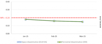
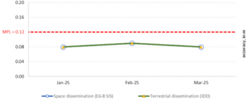
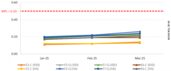
The following figures are an example of the accuracy achieved during the period from January 2025 to March 2025 (only Galileo): | |||
<center> | |||
<gallery widths=350 heights=150> | |||
File:HAS accuracy of the Galileo orbit corrections.png|'''''HAS accuracy of the Galileo orbit corrections''''' | |||
File:HAS accuracy of the Galileo clock corrections.png|'''''HAS accuracy of the Galileo clock corrections''''' | |||
File:HAS accuracy of the Galileo code biases.png|'''''HAS accuracy of the Galileo code biases''''' | |||
</gallery> | |||
</center> | |||
Refer to [https://www.gsc-europa.eu/electronic-library/performance-reports/galileo-high-accuracy-service-has EUSPA, Galileo HAS Performance Reports] for quarterly published performance reports of Galileo HAS. | |||
Current Galileo SAR Service performance can be expressed in terms of MPLs for the contribution to the SAR Forward and Return link services as it is indicated in the [https://www.gsc-europa.eu/sites/default/files/sites/all/files/Galileo-SAR-SDD.pdf Galileo SAR Service Definition document]. | |||
The SAR MPLs are divided into SAR/Galileo Forward Link Service, SAR/Galileo Return Link Service, and SAR/Galileo Space Availability: | |||
<div style="text-align:center;"> | |||
{| class="wikitable" style="display:inline-table;" | |||
! SAR/GALILEO FORWARD LINK SERVICE | |||
! style="text-align:center;" | TARGET VALUE | |||
|- | |||
| style="text-align:center;" | Forward Link Service Availability | |||
| style="text-align:center;" | >99% | |||
|- | |||
| style="text-align:center;" | European MEOLUT Facility availability in Nominal mode | |||
| style="text-align:center;" | >95% | |||
|- | |||
| style="text-align:center;" | European MEOLUT Facility availability in Degraded mode | |||
| style="text-align:center;" | >97.5% | |||
|- | |||
| style="text-align:center;" | Detection probability: Valid Message | |||
| style="text-align:center;" | >99% | |||
|- | |||
| style="text-align:center;" | Location probability within 5km (1–12 Bursts) | |||
| style="text-align:center;" | >95% | |||
|- | |||
| style="text-align:center;" | Location probability within 5km (Single Burst) | |||
| style="text-align:center;" | >90% | |||
|- | |||
| style="text-align:center;" | Location probability (Single Burst) | |||
| style="text-align:center;" | >90% | |||
|- | |||
| style="text-align:center;" | Location probability (1–12 Bursts) | |||
| style="text-align:center;" | >98% | |||
|- | |||
| style="text-align:center;" | Location probability within 2km (1–12 Bursts) | |||
| style="text-align:center;" | >90% | |||
|} | |||
</div> | |||
<div style="text-align:center;"> | |||
{| class="wikitable" style="display:inline-table;" | |||
! SAR/GALILEO RETURN LINK SERVICE | |||
! style="text-align:center;" | TARGET VALUE | |||
|- | |||
| style="text-align:center;" | Return Link Service Availability | |||
| style="text-align:center;" | >95% | |||
|- | |||
| style="text-align:center;" | End-to-end Return Link Service Availability | |||
| style="text-align:center;" | >90% | |||
|- | |||
| style="text-align:center;" | Galileo System Message Delivery Latency within 15 minutes | |||
| style="text-align:center;" | >99% | |||
|- | |||
| style="text-align:center;" | End-to-end Message Delivery Loop Latency within 30 minutes | |||
| style="text-align:center;" | >95% | |||
|} | |||
</div> | |||
<div style="text-align:center;"> | |||
{| class="wikitable" style="display:inline-table;" | |||
|+ style="caption-side:bottom;"|''[https://www.gsc-europa.eu/sites/default/files/sites/all/files/Galileo-SAR-SDD.pdf Galileo SAR MPLs]'' | |||
! SAR/GALILEO SPACE AVAILABILITY | |||
! style="text-align:center;" | TARGET VALUE | |||
|- | |||
| style="text-align:center;" | SAR Repeater Availability | |||
| style="text-align:center;" | >95% | |||
|} | |||
</div> | |||
The SAR MPLs are currently mostly meet but variates with the location and the month. MPL fulfilment status dashboards for Detection and Location, Space Segment Availability, and Ground Segment Availability are published for each quarter of the year at the [https://www.gsc-europa.eu/electronic-library/performance-reports/search-and-rescue-sar-galileo-service EUSPA, Galileo SAR Performance Reports]. | |||
In the case of the [[Galileo Public Regulated Service (PRS)|Galileo Public Regulated Service (PRS)]], the [[GNSS Performances|performance]] requirements include horizontal and vertical [[Accuracy|accuracy]]. The [[Availability|availability]] of the service should be 99.5%. | |||
See the article [[Galileo Performances|Galileo Performances]] for further information. | |||
==Credits== | ==Credits== | ||
Edited by GMV, using information from ESA and European Union as indicated through the references. | Edited by GMV, using information from ESA, European GNSS Service Centre and European Union as indicated through the references. | ||
==Notes== | ==Notes== | ||
Latest revision as of 11:40, 17 April 2026
| GALILEO | |
|---|---|
| Title | Galileo General Introduction |
| Edited by | GMV |
| Level | Basic |
| Year of Publication | 2025 |

Galileo is Europe’s own global navigation satellite system, providing a highly accurate, guaranteed global positioning service under civilian control. It is inter-operable with others GNSS such as GPS, GLONASS and BEIDOU. Galileo receivers compute their position in the Galileo Reference System using satellite technology and based on trilateration principles.
The Galileo system started its initial services on December 15th, 2016, [1] and continues to evolve with infrastructure deployment towards Full Operational Capability (FOC).
Galileo system is in constant improvement, leading to a Galileo Second Generation (G2) satellites which will revolutionize the Galileo fleet. G2 satellites are much larger, with significant changes with respect to the first version like the use of electric propulsion, an enhanced antenna with larger radiation area, inter-satellite links between the satellites which will reduce their dependency on the availability of ground installations and the addition of two atomic clocks. Moreover, G2’s fully digital payloads are being designed to be easily reconfigured in orbit, enabling them to actively respond to the evolving needs of users with novel signals and services.[2]
Introduction

Galileo is Europe's Global Navigation Satellite System (GNSS), offering highly accurate, civilian-controlled positioning, navigation, and timing services. Galileo is designed to be fully interoperable with GPS, GLONASS, and BeiDou, providing enhanced reliability and precision. The system operates with a constellation of satellites in Medium Earth Orbit (MEO) at an altitude of 23,222 km, ensuring continuous global coverage. From most locations, six to eight satellites will always be visible [3], reaching high values of availability even under challenging conditions. Moreover, Galileo signals are transmitted in four frequency bands (E5a, E5b, E6 and E1), enabling single and dual frequency positioning for users equipped with suitable receivers allowing positions and timing to be determined very accurately to within a few centimetres. As of 2025, Galileo provides positioning accuracy up to 20 cm horizontally and 40 cm vertically.[4]
Satellite navigation has become deeply integrated into everyday life, supporting industries and activities that we often take for granted. From personal and transport navigation to precision operations such as autonomous vehicles, GNSS is a critical service. However, the consequences of losing access to these signals would be severe. Truck and taxi drivers, airline crews, and maritime vessels would be unable to navigate effectively. Additionally, financial transactions, telecommunications, and emergency services would be significantly impacted, leading to chaos in public and private sectors. To mitigate such risks, Galileo ensures that satellite navigation remains under civilian authority, giving Europe greater autonomy and control over its satellite-based services. Providing a robust GNSS solution upon the potential unavailability of other GNSS systems.
With the launch and ongoing expansion of Galileo, these risks are greatly reduced. By diversifying the sources of GNSS signals, Galileo offers users a more resilient and reliable navigation service. In addition, its civilian control ensures transparency and accountability, enhancing public trust. Beyond improving basic navigation services, Galileo’s advanced capabilities also support precise timing and synchronization, which are essential for critical sectors such as banking, telecommunications, and scientific research.
The combination of Galileo and GPS signals ( GNSS Inter-Operability) in dual receivers opens the door to new GNSS applications that require a higher level of precision than currently available with GPS alone. Examples of these applications are: increase the success rate of rescue operations in the mountains, monitoring of the distribution and dilution of chemicals for agriculture interests, etc.[5]
In addition, Galileo enhances the overall availability and coverage of GNSS signals. For instance, its large constellation of satellites improves signal accessibility in densely populated urban areas, where tall buildings can obstruct signals from satellites low on the horizon.[6]
With Galileo, Europe is able to exploit the opportunities provided by satellite navigation to the full extent. GNSS Receivers and equipment manufacturers, application providers and service operators benefit from novel business opportunities.[5][6]
History and Development
As early as the 1990s, the European Union saw the need for Europe to have its own global satellite navigation system.[7]The conclusion to build one was taken in similar spirit to other decisions made in the 1970s to embark on other well-known European endeavours, such as the Ariane launcher and the formation of the Airbus Industrie GIE consortium. The European Union and European Space Agency joined forces to build Galileo, an independent European system under civilian control.
The definition phase and the development and In-Orbit Validation phase of the Galileo program were carried out by the European Space Agency and co-funded by ESA and the European Union. The Full Operational Capability phase of the Galileo program is fully funded by the European Union and managed by the European Commission. The Commission and the European Space Agency signed a delegation agreement by which ESA acts as design and procurement agent on behalf of the Commission.
The Galileo program was structured according to three main phases[6]: In-Orbit Validation (IOV), Initial Operational Capability (IOC) and Full Operational Capability (FOC) phases.
GALILEO Services
The Galileo mission and services were elaborated during the initial definition phase in consultation with user communities and the Member States. The high-performance services that the Galileo system offers for users worldwide are the followings:[8]
- Open Service (OS): The freely accessible Open Service targets the mass market and is intended for motor vehicle navigation and location-based mobile telephone services. Free to the user, it provides positioning and synchronization information intended for high-volume satellite radio navigation applications; Galileo Open Service will include in the short term an authentication mechanism through Galileo OS-NMA.
- High Accuracy Service (HAS):The HAS is an open access and free of charge service based on the provision of precise corrections (orbit, clock, biases) transmitted in the Galileo E6 signal (E6-B, data component) as well as via the internet, allowing the user to achieve improved positioning performance. The HAS signal can be encrypted in order to control access to the Galileo HAS services.
- Public Regulated Service (PRS): The Public Regulated Service is restricted to government-authorised users, for sensitive applications which require a high level of service continuity. It will be encrypted and designed to be more robust, with anti-jamming mechanisms and reliable problem detection. This service is intended for security and strategic infrastructure (e.g. energy, telecommunications and finance).
- Search and Rescue Service (SAR): Galileo's worldwide search and rescue service will help to forward distress signals to a rescue coordination centre by detecting emergency signals transmitted by beacons and relaying messages to them.
Later, new services emerged and are currently under development with G2 satellites incorporation. These services are the followings:[8]
- Open Service navigation Message Authentication (OSNMA): Free of charge supplementary service to the Galileo Open Service (OS), designed to enhance the reliability and security of the system. OSNMA ensures that the Galileo navigation messages received by users are authentic, confirming that they originate from the Galileo satellite constellation. By providing this layer of authentication, OSNMA helps protect against spoofing and signal manipulation, offering users greater confidence in the integrity of the data. This is especially crucial for applications requiring high precision and trust, such as aviation, maritime navigation, and critical infrastructure. OSNMA enhances the overall security of Galileo, aligning with Europe’s goal of offering secure and dependable GNSS services under civilian control. The incorporation of G2 satellites improves the robustness of this service, with advanced jamming and spoofing protection mechanisms to safeguard Galileo signals.
- Signal Authentication Service (SAS): Service which enables an authenticated positioning service by complementing the OSNMA with E6-based ranging authentication capabilities targeting to support civil applications.
- Galileo Emergency Warning Satellite Service (EWSS): Service which allows national civil protection authorities to rapidly transmit alerts to smartphones (or any Galileo-enabled device) in any place of the globe for enhanced emergency response and resilient risk management. The alert service is independent of the mobile communication infrastructure, and remains operational even when existing systems have been destroyed or are not available (e.g. network saturation or poor mobile network coverage).
- Timing Service (TS): The Galileo OS offers free positioning and timing/synchronization data. Currently, its timing capabilities are limited to basic determination and dissemination. However, the Galileo Programme has identified the need to expand these features into dedicated, enhanced Timing Services in the Galileo Second Generation. This upgrade will focus on supporting Critical Infrastructure applications by providing features like the Timing service Level Monitoring (TSLM) which consists in monitoring the GST and UTC accuracy.
GALILEO Architecture

To ensure these Galileo services, a specific architecture is deployed. The Galileo system is divided into three major segments: Space Segment, Ground Segment and User Segment. For details see Galileo Architecture.
The main functions of the Galileo Space Segment are to generate and transmit code and carrier phase signals with a specific Galileo signal structure, and to store and retransmit the navigation message sent by the Ground Segment. These transmissions are controlled by Passive Hydrogen Masers (PHMs) and Rubidium (RAFS) atomic clocks on board the satellites.
The Galileo satellite system nominal constellation uses a specific layout in space called a 24/3/1 Walker constellation. This means there are 24 main satellites orbiting the Earth at Medium Earth Orbit (MEO), divided into 3 equally spaced orbital planes and completing a full orbit around the Earth in 14 hours. These planes are tilted at 56 degrees from the Equator, allowing the satellites to cover most of the globe. The orbits are spaced 120 degrees apart, ensuring consistent global coverage.
In addition to the main satellites, extra (auxiliary) satellites can also be added. These don't follow the original layout and are placed in other available positions to support the system.
The Galileo constellation consists of over 30 satellites, the majority of which are operational and actively contributing to service provision, while a few may be temporarily unavailable.[9]
The Ground Segment (also referred to as Control Segment) is the responsible for the proper operation of the GNSS system. Its basic functions are:
- To control and maintain the status and configuration of the satellite constellation.
- To predict ephemeris and satellite clock evolution.
- To keep the corresponding GNSS time scale (through atomic clocks).
- To update the navigation messages for all the satellites.
The Ground Segment constitutes the major system element controlling the entire constellation, the navigation system facilities and the dissemination services. It is composed of two Galileo Control Centres (GCC), each composed of a Ground Control Segment (GCS) and a Ground Mission Segment (GMS).
In one hand, the GCS manages and monitors the satellites and their equipment, as well as planning and automating tasks to ensure everything operates safely and correct. It also supports operations related to the satellite payloads. On the other hand, the GMS determines the navigation and timing data part of the navigation messages.
A worldwide network of ground stations implementing monitoring and control functions are needed for the GCS and GMS. These are the Galileo Sensor Stations (GSS), the Telemetry, Tracking and Control stations (TT&C), and the Galileo Uplink Stations (ULS). The GSS provides Galileo SIS measurements and data to the GCCs. The Telemetry, Tracking and Control stations (TT&C) provide telemetry data and uplinks the control commands required to maintain the Galileo satellites. Finally, the Galileo Uplink Stations (ULS) distribute and uplink the mission data to the Galileo constellation.[10]
The Galileo User Segment is composed of Galileo Receivers. Their main function is to receive Galileo signals, determine pseudoranges (and other observables), and solve the navigation equations to obtain their coordinates and provide a very accurate time.
Galileo Signal Characteristics
The Galileo navigation Signals are transmitted in the four frequency bands indicated in the next figure. These four frequency bands are the E5a, E5b, E6 and E1 bands. They provide a wide bandwidth for the transmission of the Galileo Signals.[11]

The Galileo frequency bands have been selected in the allocated spectrum for Radio Navigation Satellite Services (RNSS). In addition to that, E5a, E5b and E1 bands are included in the allocated spectrum for Aeronautical Radio Navigation Services (ARNS), employed by Civil-Aviation users, and allowing dedicated safety-critical applications. The names of the Galileo signals are the same as the corresponding carrier frequencies. Note that E5a and E5b signals are part of the E5 bandwidth.[11]
GALILEO Performances
The Galileo performances are different for each service.
For Open Service (OS), the positioning accuracy MPLs for SF and DF, and depending on the user location are:
| GALILEO OS POSITIONING ACCURACY | HORIZONTAL ERROR | VERTICAL ERROR | ||
|---|---|---|---|---|
| SF | DF | SF | DF | |
| Average user location | ≤ 5m (95%) | ≤ 5m (95%) | ≤ 8m (95%) | ≤ 8m (95%) |
| Worst user location | ≤ 10m (95%) | ≤ 10m (95%) | ≤ 16m (95%) | ≤ 16m (95%) |
Currently, the Open Service (OS) meet these requirements and achieve values of around 1.5 and 2.5 meters (HPE and VPE, correspondingly) for dual frequency combinations (E1/E5a and E1/E5b).
The following figures are an example of the positioning performances achieved during January 2025 (E1/E5a and E1/E5b):


HPE statistics for Galileo users in January 2025.


VPE statistics for Galileo users in January 2025.
Refer to EUSPA, Galileo Open Service Performance Reports for quarterly published performance reports of Galileo OS.
The characterisation of Galileo OS in terms of integrity and continuity is currently under development. However, the Probability of SIS Fault and the Probability of Constellation Fault are parameters which help in giving a cofinance at any instantaneous signal. The Probability of SIS Fault is defined as the probability that the instantaneous ranging signal error of a healthy Galileo satellite (excluding atmospheric and receiver errors) exceeds “k” times (being factor “k” the number of standard deviations from the mean corresponding to a probability of Psat in a normal distribution) the Galileo user range accuracy (Galileo URA). And the Probability of Constellation Fault is the probability that the instantaneous ranging signal error of two or more healthy Galileo satellites (also excluding atmospheric and receiver errors) exceeds “k” times the Galileo URA due to a common failure [12]. The MPLs for these probabilities (factor “k” being 4.17) are defined in the following table:
| Parameter | Value |
|---|---|
| GALILEO PROBABILITY OF SINGLE SIS FAULT (Psat) | ≤ 3·10−5 |
| GALILEO PROBABILITY OF CONSTELLATION N SIS FAULT (Pconst) | ≤ 2·10−4 |
For the High Accuracy Service (HAS), the MPLs are computed as the RMS over the instantaneous constellation average, for a period of 30 days:
| FIGURE OF MERIT | MPL – Galileo | MPL – GPS |
|---|---|---|
| HAS orbit corrections accuracy | ≤ 20cm (95%) | ≤ 33cm (95%) |
| HAS clock corrections accuracy | ≤ 12cm (95%) | ≤ 15cm (95%) |
| HAS code biases accuracy | ≤ 50cm (95%) | |
Currently, the Galileo High Accuracy Service (HAS) meet these requirements with accuracy values of around 15 and 18 centimetres (Galileo and GPS respectively) for the orbit corrections, 7 and 10 centimetres for the clock corrections, and lower than 40 centimetres (both Galileo and GPS) for the code biases.
The following figures are an example of the accuracy achieved during the period from January 2025 to March 2025 (only Galileo):
-
 HAS accuracy of the Galileo orbit corrections
 -
 HAS accuracy of the Galileo clock corrections
 -
 HAS accuracy of the Galileo code biases


Refer to EUSPA, Galileo HAS Performance Reports for quarterly published performance reports of Galileo HAS.
Current Galileo SAR Service performance can be expressed in terms of MPLs for the contribution to the SAR Forward and Return link services as it is indicated in the Galileo SAR Service Definition document.
The SAR MPLs are divided into SAR/Galileo Forward Link Service, SAR/Galileo Return Link Service, and SAR/Galileo Space Availability:
| SAR/GALILEO FORWARD LINK SERVICE | TARGET VALUE |
|---|---|
| Forward Link Service Availability | >99% |
| European MEOLUT Facility availability in Nominal mode | >95% |
| European MEOLUT Facility availability in Degraded mode | >97.5% |
| Detection probability: Valid Message | >99% |
| Location probability within 5km (1–12 Bursts) | >95% |
| Location probability within 5km (Single Burst) | >90% |
| Location probability (Single Burst) | >90% |
| Location probability (1–12 Bursts) | >98% |
| Location probability within 2km (1–12 Bursts) | >90% |
| SAR/GALILEO RETURN LINK SERVICE | TARGET VALUE |
|---|---|
| Return Link Service Availability | >95% |
| End-to-end Return Link Service Availability | >90% |
| Galileo System Message Delivery Latency within 15 minutes | >99% |
| End-to-end Message Delivery Loop Latency within 30 minutes | >95% |
| SAR/GALILEO SPACE AVAILABILITY | TARGET VALUE |
|---|---|
| SAR Repeater Availability | >95% |
The SAR MPLs are currently mostly meet but variates with the location and the month. MPL fulfilment status dashboards for Detection and Location, Space Segment Availability, and Ground Segment Availability are published for each quarter of the year at the EUSPA, Galileo SAR Performance Reports.
In the case of the Galileo Public Regulated Service (PRS), the performance requirements include horizontal and vertical accuracy. The availability of the service should be 99.5%.
See the article Galileo Performances for further information.
Credits
Edited by GMV, using information from ESA, European GNSS Service Centre and European Union as indicated through the references.
Notes
References
- ^ Galileo goes live!
- ^ Galileo Second Generation
- ^ EUSPA FAQs
- ^ ESA, Applications, Satellite Navigation
- ^ a b EUSPA News archive
- ^ a b c European Commission Galileo System
- ^ Council Resolution of 19 July 1999 on the involvement of Europe in a new generation of satellite navigation services -Galileo- Definition phase
- ^ a b Galileo services in European GNSS Service Centre portal
- ^ EUSPA, Constellation Information
- ^ EUSPA, Galileo System
- ^ a b Galileo OS Signal In Space ICD
- ^ Galileo OS SDD