If you wish to contribute or participate in the discussions about articles you are invited to contact the Editor
Uploads by Jose.Caro
Jump to navigation
Jump to search
This special page shows all uploaded files.
| Date | Name | Thumbnail | Size | Description | Versions |
|---|---|---|---|---|---|
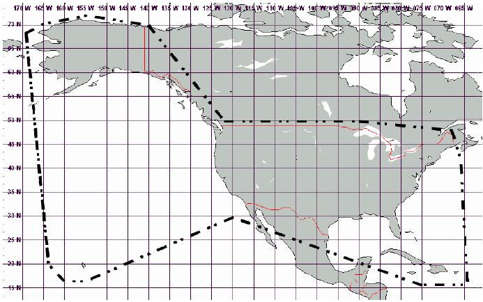
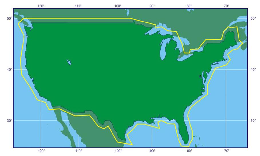
| 14:41, 22 November 2011 | WAAS zone 5.jpg (file) |  |
66 KB | WAAS Zone 1 Coverage (source: [http://www.pnt.gov/public/docs/2008/waasps2008.pdf Global Positioning System Wide Area Augmentation System (WAAS) Performance Standard], Department of Transportation and Federal Aviation Administration, USA, 1st Edition, 31 | 1 |
| 14:41, 22 November 2011 | WAAS zone 4.jpg (file) |  |
29 KB | WAAS Zone 1 Coverage (source: [http://www.pnt.gov/public/docs/2008/waasps2008.pdf Global Positioning System Wide Area Augmentation System (WAAS) Performance Standard], Department of Transportation and Federal Aviation Administration, USA, 1st Edition, 31 | 1 |
| 14:41, 22 November 2011 | WAAS zone 3.jpg (file) |  |
19 KB | WAAS Zone 1 Coverage (source: [http://www.pnt.gov/public/docs/2008/waasps2008.pdf Global Positioning System Wide Area Augmentation System (WAAS) Performance Standard], Department of Transportation and Federal Aviation Administration, USA, 1st Edition, 31 | 1 |
| 14:41, 22 November 2011 | WAAS zone 2.jpg (file) |  |
52 KB | WAAS Zone 1 Coverage (source: [http://www.pnt.gov/public/docs/2008/waasps2008.pdf Global Positioning System Wide Area Augmentation System (WAAS) Performance Standard], Department of Transportation and Federal Aviation Administration, USA, 1st Edition, 31 | 1 |
| 14:41, 22 November 2011 | WAAS zone 1.jpg (file) |  |
40 KB | WAAS Zone 1 Coverage (source: [http://www.pnt.gov/public/docs/2008/waasps2008.pdf Global Positioning System Wide Area Augmentation System (WAAS) Performance Standard], Department of Transportation and Federal Aviation Administration, USA, 1st Edition, 31 | 1 |
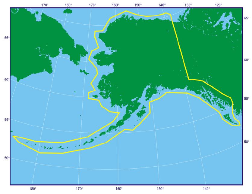
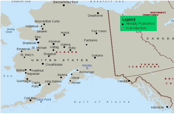
| 10:35, 29 July 2011 | Alaska Airports with WAAS approches.jpg (file) |  |
44 KB | Alaska Airports with WAAS Supported Instrument Approaches with Vertical Guidance (as of March 10, 2011). (Source: [http://www.faa.gov/about/office_org/headquarters_offices/ato/service_units/techops/navservices/gnss/approaches/index.cfm FAA.]) | 1 |
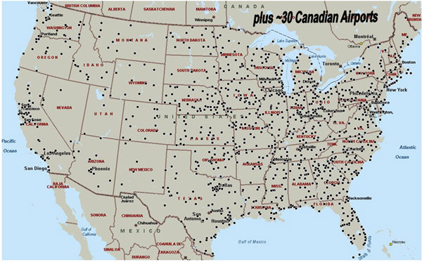
| 10:34, 29 July 2011 | Airports with wass supported approaches.jpg (file) |  |
74 KB | Airports with WAAS Supported Instrument Approaches with Vertical Guidance (as of March 10, 2011). (Source: [http://www.faa.gov/about/office_org/headquarters_offices/ato/service_units/techops/navservices/gnss/approaches/index.cfm FAA.) | 1 |
| 09:07, 12 July 2011 | Egnos geos foot print.png (file) |  |
209 KB | Foot print of EGNOS GEO satellites (source: EGNOS − The European Geostationary Navigation Overlay System − A Cornerstone of Galileo, ESA SP-1303) | 1 |
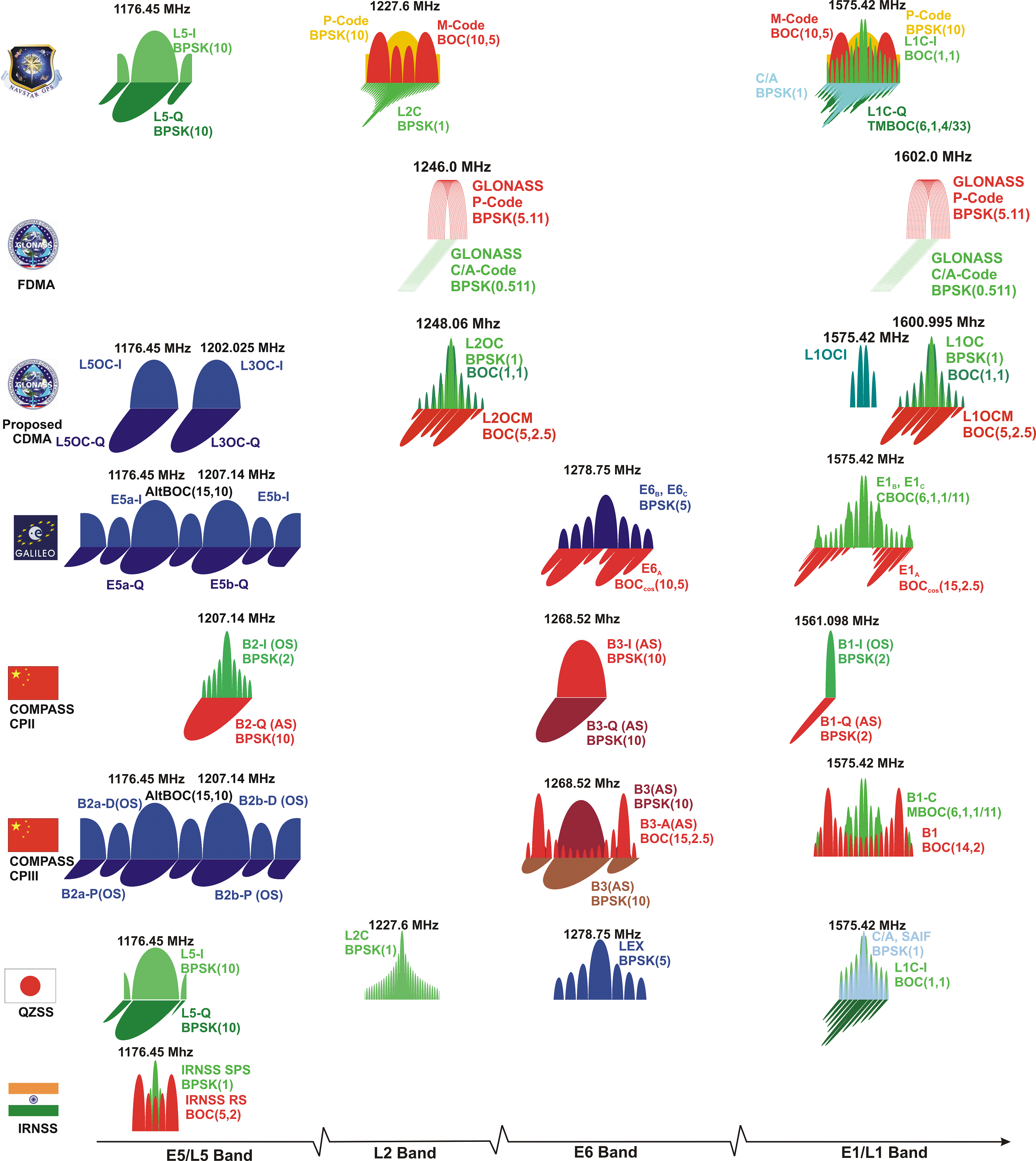
| 08:51, 28 June 2011 | Galileo Signals in Space.png (file) |  |
1.83 MB | 2 | |
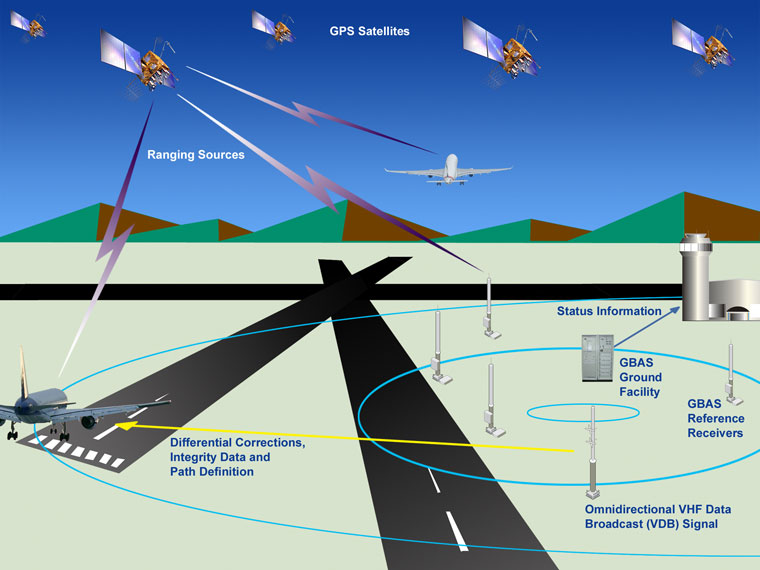
| 11:40, 23 May 2011 | LAAS Architecture.png (file) |  |
384 KB | 2 | |
| 17:04, 1 April 2011 | Egnos rims.png (file) |  |
193 KB | (image taken from [http://www.esa.int/esaMI/ESA_Publications/SEMNMPN0LYE_0.html ESA EGNOS book SP-1303]) | 1 |
| 17:04, 1 April 2011 | Egnos nles test.png (file) |  |
162 KB | (image taken from [http://www.esa.int/esaMI/ESA_Publications/SEMNMPN0LYE_0.html ESA EGNOS book SP-1303]) | 1 |
| 17:04, 1 April 2011 | Egnos cpfps.png (file) |  |
543 KB | (image taken from [http://www.esa.int/esaMI/ESA_Publications/SEMNMPN0LYE_0.html ESA EGNOS book SP-1303]) | 1 |
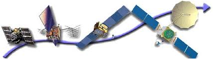
| 13:55, 1 April 2011 | SBAS architecture.png (file) |  |
780 KB | SBAS architecture (adapted from image taken from ESA EGNOS book SP-1303). | 1 |
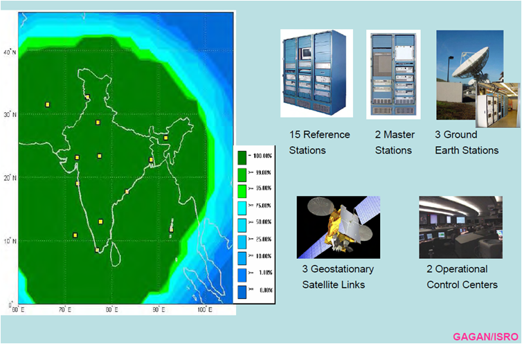
| 23:41, 31 March 2011 | Gagan overview.png (file) |  |
475 KB | GAGAN system overview (taken from the presentation [http://www.bangkok.icao.int/meetings/2009/nsfvfp/sp03.pdf ''GAGAN Signal In Space – Testing &Utilisation'']) | 1 |
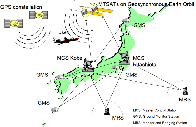
| 23:36, 31 March 2011 | Msas overview.png (file) |  |
147 KB | MSAS architecture (taken from presentation [http://www.unoosa.org/pdf/icg/2009/icg-4/05-2.pdf Overview of MTSAT Satellite-based Augmentation System (MSAS)]) | 1 |
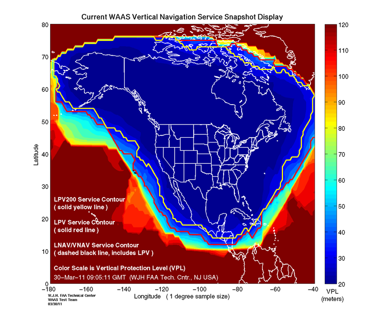
| 23:26, 31 March 2011 | Waas performance.png (file) |  |
231 KB | WAAS LPV-200 performances (source: [http://www.nstb.tc.faa.gov/Full_VerticalProtectionLevel.htm FAA]) | 1 |
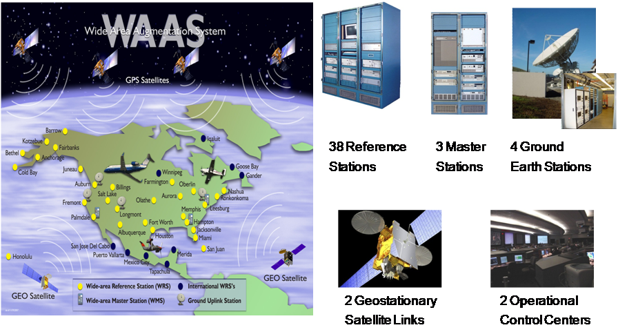
| 23:14, 31 March 2011 | Waas architecture.png (file) |  |
561 KB | WAAS system overview (source: [http://www.navcen.uscg.gov/pdf/cgsicMeetings/50/%5B27%5DEldredge_WAAS_LAAS.pdf presentation provided in the 50th Civil GPS Service Interface Committee (CGSIC) Meeting September 21 2010 in Portland (NAVCEN/USCG )]). | 1 |
| 23:09, 31 March 2011 | Waas logo.gif (file) | 2 KB | 2 | ||
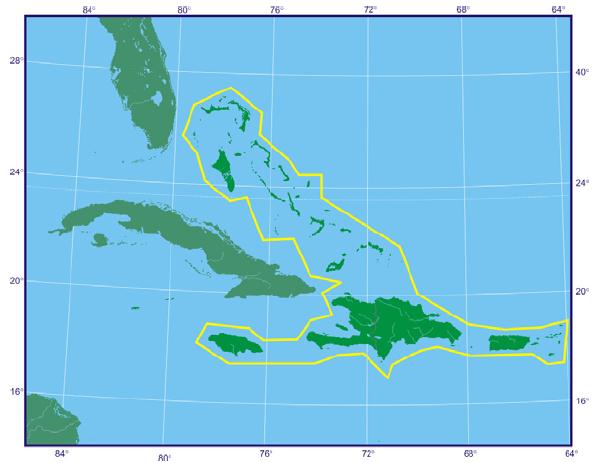
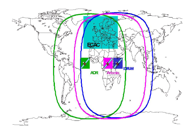
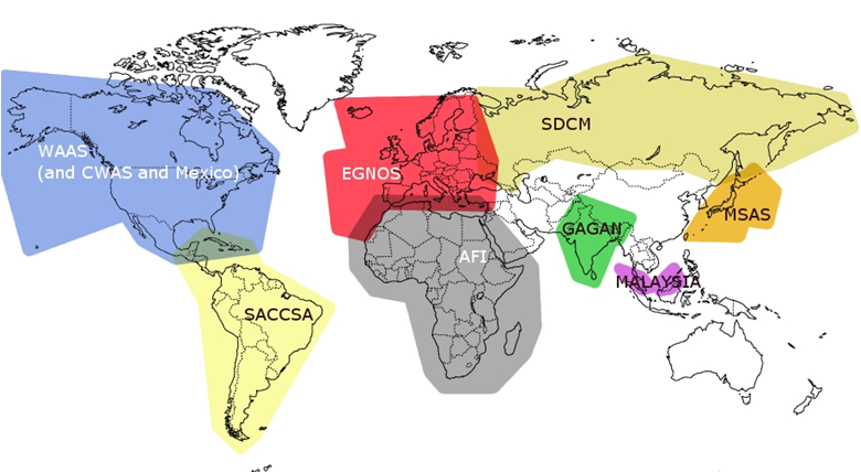
| 22:59, 31 March 2011 | SBAS in the world.png (file) |  |
222 KB | Some SBAS systems are either operational, under implementation or under feasibility studies in several regions in the world (source: [http:/www.gmv.com GMV]). | 1 |
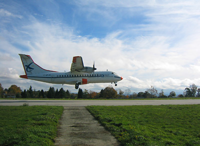
| 22:01, 31 March 2011 | ATR42 trial.jpg (file) |  |
40 KB | The Direction Générale de l'Aviation Civile (DGAC) ATR42 test aircraft about to touch down at Limoges airport during trials of the European Geostationary Navigation Overlay Service (EGNOS). The quality of the EGNOS signals was analysed by comparing the | 1 |
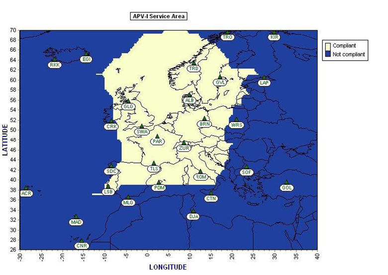
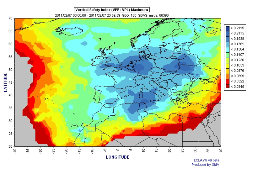
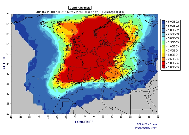
| 21:54, 31 March 2011 | Egnos ref apv1.png (file) |  |
428 KB | Service Area against which the APV-I is to be achieved over 99% of time for both operational EGNOS GEO satellites, GEO 120 and 124. (Source: [http://www.essp-sas.eu/downloads/hibt/essp_dil51_r2010p_01_02.pdf EGNOS Yearly Report].) | 1 |
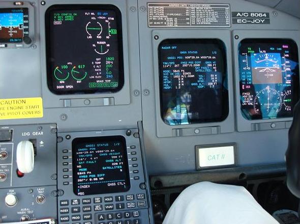
| 21:12, 31 March 2011 | EGNOS equipped Aircraft.jpg (file) |  |
54 KB | EGNOS-equipped cockpit (source: [http://www.esa.int/esaCP/SEMA0ZUTLKG_Spain_1.html ESA]). | 1 |
| 20:54, 31 March 2011 | Egnos 4.png (file) |  |
352 KB | EGNOS Safety of Life certified for civil aviation (source: [http://www.esa.int/images/despegue2B.JPG ESA]). | 1 |
| 18:26, 31 March 2011 | Tour de france EGNOS.jpg (file) |  |
57 KB | Lance Amstron´s arrival at the Summit of Alpe d´Huez where riders were tracked with EGNOS (source: [http://www.esa.int/esaNA/ESAG130VMOC_egnos_1.html#subhead6 ESA]). | 1 |
| 18:20, 31 March 2011 | Egnos 3.png (file) |  |
461 KB | EGNOS Open Service declared available in October 2009 (source: [http://ec.europa.eu/enterprise/policies/satnav/egnos/files/brochures-leaflets/egnos-leaflet_en.pdf EGNOS brochures]) | 1 |
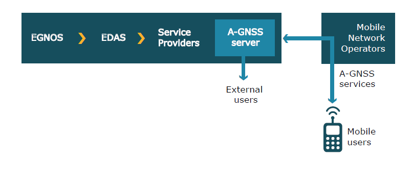
| 17:59, 31 March 2011 | Edas eg.png (file) |  |
18 KB | Potential GNSS Service Architecture using EDAS (source: [http://www.gsa.europa.eu/go/egnos/edas/edas-brochures European GNSS Agency]). | 1 |
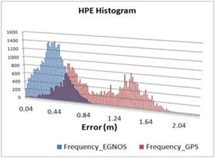
| 17:34, 31 March 2011 | MagicGemini 1.png (file) |  |
61 KB | Horizontal Navigation Solution Error (HNSE) histogram computed for a user receiver located in Berlin both for GPS and GPS-EGNOS solutions. The accuracy gain obtained with EGNOS is easily appreciated. (Source: [http://www.gmv.com GMV] product magicGEMINI.) | 1 |
| 17:26, 31 March 2011 | Egnos 2.png (file) |  |
118 KB | EGNOS – The Groundbreaking European Satellite Navigation System (source: [http://ec.europa.eu/enterprise/policies/satnav/egnos/files/brochures-leaflets/egnos-leaflet_en.pdf EGNOS brochure]) | 1 |
| 17:26, 31 March 2011 | Egnos 1.png (file) |  |
110 KB | EGNOS – The Groundbreaking European Satellite Navigation System (source: [http://ec.europa.eu/enterprise/policies/satnav/egnos/files/brochures-leaflets/egnos-leaflet_en.pdf EGNOS brochure]) | 1 |
| 16:45, 31 March 2011 | App transport.png (file) |  |
91 KB | Example of GNSS application (source: http://www.gps.gov/applications/ GPS.gov | 1 |
| 16:45, 31 March 2011 | App agriculture.png (file) |  |
84 KB | Example of GNSS application (source: http://www.gps.gov/applications/ GPS.gov | 1 |
| 16:42, 31 March 2011 | App survey.jpg (file) |  |
13 KB | Example of GNSS application (source: http://www.gps.gov/applications/ GPS.gov | 1 |
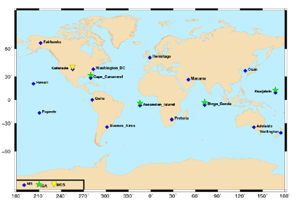
| 15:52, 31 March 2011 | GPS infrastructure.png (file) |  |
108 KB | GPS ground infrastructure (source: J. Sanz Subirana, JM. Juan Zornoza and M. Hernández-Pajares, ''Global Navigation Satellite Systems: Volume I: Fundamentals and Algorithms'') | 1 |
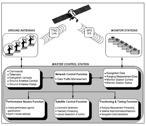
| 15:37, 31 March 2011 | GPS ground segment.png (file) |  |
63 KB | The GPS Operational Control System (OCS) (source: SPS Standard) | 1 |
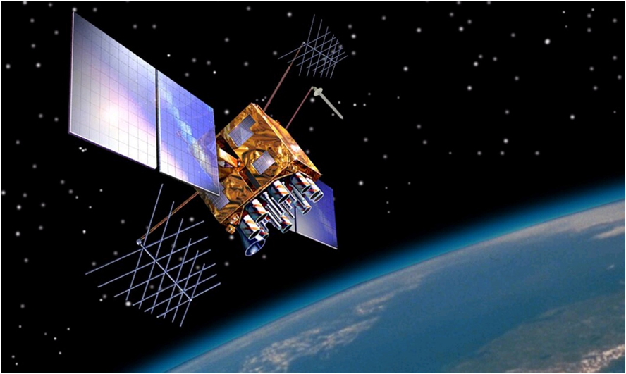
| 15:21, 31 March 2011 | Gps sat san diego.jpg (file) |  |
302 KB | GPS satellite on public display at the San Diego Aerospace Museum (author: Scott Ehardt http://en.wikipedia.org/wiki/File:Global_Positioning_System_satellite.jpg wikipedia) | 1 |
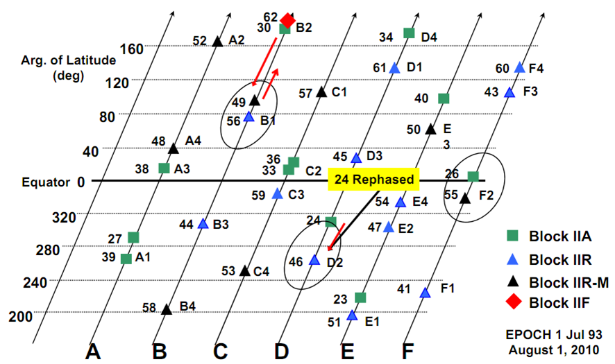
| 14:55, 31 March 2011 | GPS expanded constellation.png (file) |  |
167 KB | GPS Expanded constellation (source: [http://www.navcen.uscg.gov/pdf/cgsicMeetings/50/%5B23%5DLtCol_Steiner_GPS_Program_Status_CGSIC_v5k.pdf U.S. Coast Guard Navigation Center - NAVCEN]) | 1 |
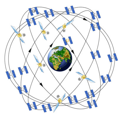
| 14:11, 31 March 2011 | GPS constellation.gif (file) |  |
35 KB | GPS Constellation (source: [http://www.gps.gov/multimedia/images/constellation.gif www.gps.gov]) | 1 |
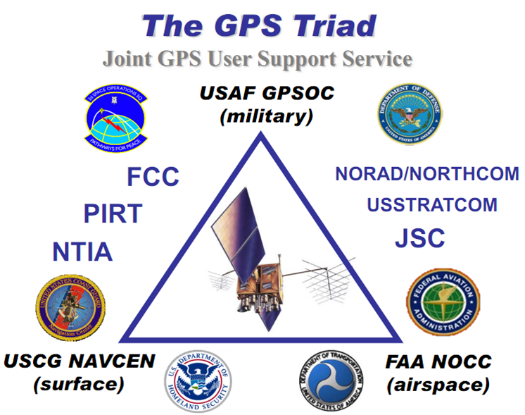
| 13:33, 31 March 2011 | GPS triad.png (file) |  |
288 KB | The GPS Triad (source: [http://www.navcen.uscg.gov/pdf/cgsicMeetings/50/%5B26%5DHamilton_CGSIC_2010.pdf]) | 1 |
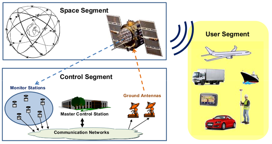
| 13:22, 31 March 2011 | GPS architecture.png (file) |  |
247 KB | GPS segments (source: ''J. Sanz Subirana, JM. Juan Zornoza and M. Hernández-Pajares, Global Navigation Satellite Systems: Volume I: Fundamentals and Algorithms'') | 1 |
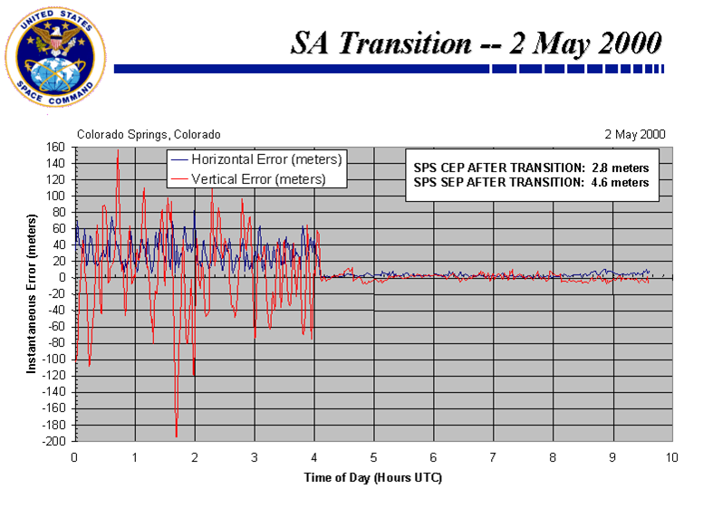
| 13:00, 31 March 2011 | SA removal.png (file) |  |
132 KB | GPS Accuracy Before and After SA Removal (source: http://www.pnt.gov/public/sa/diagram.shtml) | 1 |
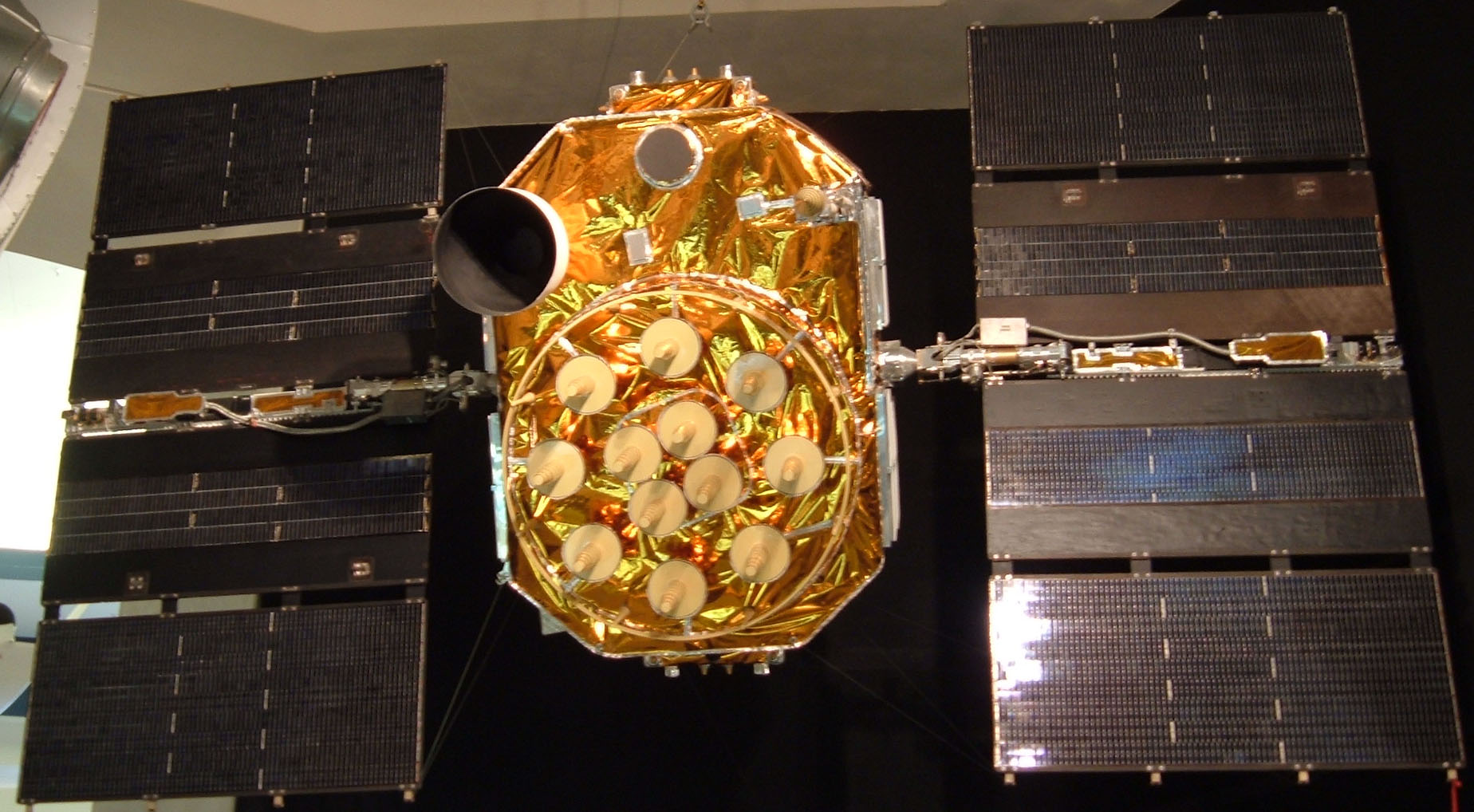
| 12:40, 31 March 2011 | GPS satellite block IIR M.png (file) |  |
566 KB | GPS Satellite Block IIR-M (Source: http://www.gps.gov/multimedia/images/IIR-M_2.jpg) | 1 |
| 12:40, 31 March 2011 | GPS modernization.png (file) |  |
76 KB | GPS Modernization (source: http://www.pnt.gov/101/modernization.jpg) | 1 |
| 16:50, 30 March 2011 | EGNOS performances integrity.png (file) |  |
346 KB | EGNOS typical integrity | 1 |
| 16:49, 30 March 2011 | EGNOS performances continuity.png (file) |  |
331 KB | EGNOS typical continuity | 1 |
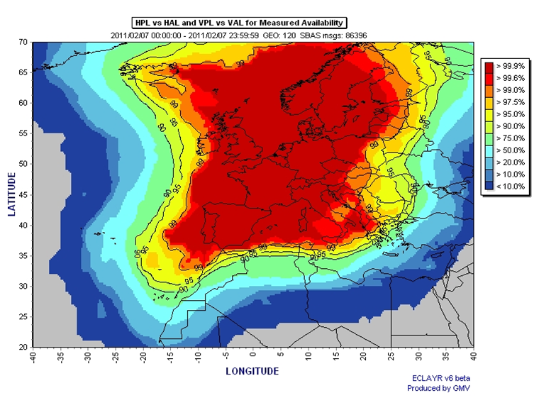
| 16:48, 30 March 2011 | EGNOS performances availability.png (file) |  |
368 KB | EGNOS typical availability | 1 |
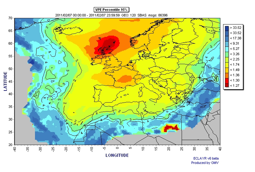
| 16:47, 30 March 2011 | EGNOS performances accuracy.png (file) |  |
410 KB | EGNOS typical accuracy | 1 |
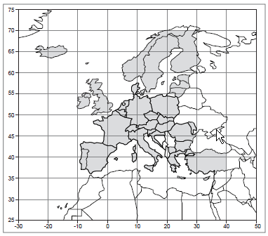
| 16:46, 30 March 2011 | EGNOS performances ECAC land masses.png (file) |  |
28 KB | ECAC 96 land masses (source: EGNOS Mission Requirement Document) | 1 |
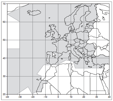
| 16:41, 30 March 2011 | EGNOS performances ECAC FIR96.png (file) |  |
26 KB | ECAC 96 FIRs (source EGNOS Mission Requirement Document) | 1 |