If you wish to contribute or participate in the discussions about articles you are invited to contact the Editor
WAAS Space Segment: Difference between revisions
m (Included editor logo.) |
No edit summary |
||
| Line 7: | Line 7: | ||
|Title={{PAGENAME}} | |Title={{PAGENAME}} | ||
}} | }} | ||
The Wide Area Augmentation System ([[WAAS General Introduction|WAAS]]) is the United States [[SBAS General Introduction|Satellite Based Augmentation System]]. The programme, started in 1992, is being carried out by the [http://www.faa.gov/ Federal Aviation Agency (FAA)]<ref name="FAA_NAV_HISTORY">[http://www.faa.gov | The Wide Area Augmentation System ([[WAAS General Introduction|WAAS]]) is the United States [[SBAS General Introduction|Satellite Based Augmentation System]]. The programme, started in 1992, is being carried out by the [http://www.faa.gov/ Federal Aviation Agency (FAA)]<ref name="FAA_NAV_HISTORY">[http://www.faa.gov Navigation Services - History - Satellite Navigation,] [http://www.faa.gov/ FAA.]</ref> and is specially developed for the civil aviation community.<ref name="FAA_WAAS">[http://www.faa.gov/about/office_org/headquarters_offices/ato/service_units/techops/navservices/gnss/waas/ Navigation Services - Wide Area Augmentation System (WAAS)], [http://www.faa.gov/ FAA.]</ref> The system, which was declared operational in late 2003,<ref name="STANFORD_WAAS">[http://waas.stanford.edu/research/waas.htm Wide Area Differential GPS (WADGPS), Stanford University]</ref> currently supports thousands of aircraft instrument approaches in more than one thousand airports in USA and Canada.<ref name="APPROACHES">[http://www.faa.gov/about/office_org/headquarters_offices/ato/service_units/techops/navservices/gnss/approaches/index.cfm GNSS - GPS/WAAS Approaches,] [http://www.faa.gov/ Federal Aviation Agency (FAA).]</ref> WAAS service area includes CONUS, Alaska, Canada and Mexico.<ref name="WAASExpanded">[http://www.faa.gov/about/office_org/headquarters_offices/ato/service_units/techops/navservices/gnss/waas/news/ WAAS Service Expanded into Canada and Mexico, September 28, 2007,] [http://www.faa.gov/ Federal Aviation Agency (FAA).]</ref> The WAAS programme is continuously in evolution; two development phases have been already covered, a third is in progress, and there are plans to improve the capability of the system in parallel with the evolution of the SBAS standards towards a dual-frequency augmentation service.<ref name="EXTENSION">[http://www.faa.gov/about/office_org/headquarters_offices/ato/service_units/techops/navservices/gnss/library/satnav/media/SatNav_March08.pdf SatNav News, Vol. 33, March 2008,] [http://www.faa.gov/ Federal Aviation Agency (FAA).]</ref> | ||
==WAAS Space Segment== | ==WAAS Space Segment== | ||
| Line 15: | Line 15: | ||
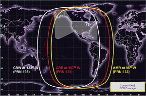
[[File:WAASGEOCoverage.PNG|Current WAAS GEO Coverage (June 2011)|300px|thumb]] | [[File:WAASGEOCoverage.PNG|Current WAAS GEO Coverage (June 2011)|300px|thumb]] | ||
As of June 2011, the Space segment consists of 3 commercial GEO satellites, [http://nssdc.gsfc.nasa.gov | As of June 2011, the Space segment consists of 3 commercial GEO satellites, [http://nssdc.gsfc.nasa.gov ''Inmarsat-4 F3''], Telesat's [http://nssdc.gsfc.nasa.gov ''Anik F1R''], and Intelsat's [http://nssdc.gsfc.nasa.gov ''Galaxy 15''], which has resumed service in March, 2011.<ref name="WAAS News">[http://www.faa.gov/about/office_org/headquarters_offices/ato/service_units/techops/navservices/gnss/waas/news/ FAA WAAS News]</ref> | ||
The list of GEO satellites used in WAAS (also in the past) are in the following table:<ref name="WAAS_WIKI">[http://en.wikipedia.org/wiki/Wide_Area_Augmentation_System Wide Area Augmentation System in Wikipedia]</ref> | The list of GEO satellites used in WAAS (also in the past) are in the following table:<ref name="WAAS_WIKI">[http://en.wikipedia.org/wiki/Wide_Area_Augmentation_System Wide Area Augmentation System in Wikipedia]</ref> | ||
Revision as of 13:26, 30 September 2018
| WAAS | |
|---|---|
| Title | WAAS Space Segment |
| Edited by | GMV |
| Level | Basic |
| Year of Publication | 2011 |
The Wide Area Augmentation System (WAAS) is the United States Satellite Based Augmentation System. The programme, started in 1992, is being carried out by the Federal Aviation Agency (FAA)[1] and is specially developed for the civil aviation community.[2] The system, which was declared operational in late 2003,[3] currently supports thousands of aircraft instrument approaches in more than one thousand airports in USA and Canada.[4] WAAS service area includes CONUS, Alaska, Canada and Mexico.[5] The WAAS programme is continuously in evolution; two development phases have been already covered, a third is in progress, and there are plans to improve the capability of the system in parallel with the evolution of the SBAS standards towards a dual-frequency augmentation service.[6]
WAAS Space Segment
The WAAS Space Segment is composed by several geosynchronous communication satellites (GEO) in charge of broadcasting, over the WAAS service area, the WAAS augmentation message.
As of June 2011, the Space segment consists of 3 commercial GEO satellites, Inmarsat-4 F3, Telesat's Anik F1R, and Intelsat's Galaxy 15, which has resumed service in March, 2011.[7]
The list of GEO satellites used in WAAS (also in the past) are in the following table:[8]
| Satellite Name & Details | NMEA / PRN | Location |
|---|---|---|
| Inmarsat 4F3 (AMR) | NMEA #46 / PRN #133 | 98°W |
| Galaxy 15 (CRW) | NMEA #48 / PRN #135 | 133°W |
| Telesat Anik F1R (CRE) | NMEA #51 / PRN #138 | 107.3°W |
| Inmarsat 3F3 (POR) Ceased WAAS transmissions |
NMEA #47 / PRN #134 | 178°E |
| Inmarsat 3F4 (AOR-W) Ceased WAAS transmissions |
NMEA #35 / PRN #122 | 142°W |
Notes
References
- ^ Navigation Services - History - Satellite Navigation, FAA.
- ^ Navigation Services - Wide Area Augmentation System (WAAS), FAA.
- ^ Wide Area Differential GPS (WADGPS), Stanford University
- ^ GNSS - GPS/WAAS Approaches, Federal Aviation Agency (FAA).
- ^ WAAS Service Expanded into Canada and Mexico, September 28, 2007, Federal Aviation Agency (FAA).
- ^ SatNav News, Vol. 33, March 2008, Federal Aviation Agency (FAA).
- ^ FAA WAAS News
- ^ a b Wide Area Augmentation System in Wikipedia

