If you wish to contribute or participate in the discussions about articles you are invited to contact the Editor
WAAS Performances
| WAAS | |
|---|---|
| Title | WAAS Performances |
| Author(s) | GMV |
| Level | Basic |
| Year of Publication | 2011 |

The Wide Area Augmentation System (WAAS) is the United States Satellite Based Augmentation System. The programme, started in 1992, is being carried out by the Federal Aviation Agency (FAA)[1] and is specially developed for the civil aviation community.[2] The system, which was declared operational in late 2003,[3] currently supports thousands of aircraft instrument approaches in more than one thousand airports in USA and Canada.[4] WAAS service area includes CONUS, Alaska, Canada and Mexico.[5] The WAAS programme is continuously in evolution; two development phases have been already covered, a third is in progress, and there are plans to improve the capability of the system in parallel with the evolution of the SBAS standards towards a dual-frequency augmentation service.[6]
WAAS Performance
Satellite Based Augmentation Systems (SBAS) performances are usually described in terms of integrity, accuracy, availability, and continuity. According to the WAAS performance standard,[7] WAAS service area is divided in five coverage zones:
- Zone 1: CONUS.
- Zone 2: Alaska.
- Zone 3: Hawaii.
- Zone 4: Puerto Rico and some other Caribbean islands.
- Zone 5: US territory excluding zones 1 to 4.
The volume covered includes a region up to 100.000 feet above the surface. For zones 1 to 3, the area extends up to 30 nm outside the land.
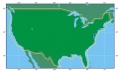
Zone 1
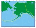
Zone 2

Zone 3
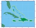
Zone 4
Zone 5


WAAS specification distinguishes the following flight phases:[7]
- En route
- Terminal
- LNAV (Lateral Navigation)
- LNAV/VNAV (Lateral Navigation/Vertical Navigation)
- LPV (Localizer Performance with Vertical guidance)
- LPV 200 (LPV 200 foot minimum)
The requirements considering the different flight phases and coverage zones are summarised in the next table:[7]
| En Route | Terminal | LNAV | LNAV/VNAV | LPV | LPV 200 | |
|---|---|---|---|---|---|---|
| TTA | 15 s | 15 s | 10 s | 10 s | 6.2 s | 6.2 s |
| HAL | 2 nm | 1 nm | 556 m | 556 m | 40 m | 40 m |
| VAL | N/A | N/A | N/A | 50 m | 50 m | 35 m |
| Probability of HMI | 10-7 per hour | 10-7 per hour | 10-7 per hour | 2 x 10⁻⁷ per approach | 2 x 10⁻⁷ per approach (150 seconds) | 2 x 10⁻⁷ per approach (150 seconds) |
| Zone 1 Continuity | 1 - 10-5 per hour | 1 - 10-5 per hour | 1 - 10-5 per hour | 1 - 5.5 x 10⁻⁵/15 seconds | 1 - 8 x 10⁻⁶/15 seconds | 1 - 8 x 10⁻⁶/15 seconds |
| Horizontal Accuracy (95%) | 0.4 nm | 0.4 nm | 220 m | 220 m | 16 m | 16 m |
| Vertical Accuracy (95%) | N/A | N/A | N/A | 20 m | 20 m | 4 m |
| Availability (Zone 1 Coverage) | 0.99999 (100%) | 0.99999 (100%) | 0.99999 (100%) | 0.99 (100%) | 0.99 (80-100%) | 0.99 (40-60%) |
| Availability (Zone 2 Coverage) | 0.999 (100%) | 0.999 (100%) | 0.999 (100%) | 0.95 (75%) | 0.95 (75%) | N/A |
| Availability (Zone 3 Coverage) | 0.999 (100%) | 0.999 (100%) | 0.999 (100%) | N/A | N/A | N/A |
| Availability (Zone 4 Coverage) | 0.999 (100%) | 0.999 (100%) | 0.999 (100%) | N/A | N/A | N/A |
| Availability (Zone 5 Coverage) | 0.99999 (100%) | 0.999 (100%) | 0.999 (100%) | N/A | N/A | N/A |
In this table, the integrity requirements are given as the probability of HMI, namely Hazardously Misleading Information. In addition to integrity, accuracy, availability and continuity, the table shows the specification for Time To Alert (TTA) and for Horizontal and Vertical Alert Limits (HAL and VAL).
On July 10, 2003, the WAAS system was certified for safety-of-life aviation, covering 95% of the contiguous U.S. and part of Alaska [3][8]. At present, WAAS supports en-route, terminal and approach operations down to a full LPV-200 (CAT-I like Approach Capability) for the CONUS, Mexico and Canada.
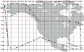
The FAA publishes real time WAAS performance at the Technical Center WAAS Test Bed web site.[9] Typical performances provided by WAAS System when considering operating in LPV (Horizontal Alarm Limit = 40 m , Vertical Alarm Limit =50 m) are shown in next figure:[9]

Notes
References
- ^ Navigation Services - History - Satellite Navigation, FAA.
- ^ Navigation Services - Wide Area Augmentation System (WAAS), FAA.
- ^ a b Wide Area Differential GPS (WADGPS), Stanford University
- ^ GNSS - GPS/WAAS Approaches, Federal Aviation Agency (FAA).
- ^ WAAS Service Expanded into Canada and Mexico, September 28, 2007, Federal Aviation Agency (FAA).
- ^ SatNav News, Vol. 33, March 2008, Federal Aviation Agency (FAA).
- ^ a b c Global Positioning System Wide Area Augmentation System (WAAS) Performance Standard, Department of Transportation and Federal Aviation Administration, USA, 1st Edition, 31 October 2008.
- ^ Wide Area Augmentation System
- ^ a b FAA Monitoring WAAS Performances in Real-Time