If you wish to contribute or participate in the discussions about articles you are invited to contact the Editor
SBAS Systems
| Fundamentals | |
|---|---|
| Title | SBAS Systems |
| Edited by | GMV |
| Level | Basic |
| Year of Publication | 2011 |

SBAS systems are spreading out all over the world. More and more, it is believed that upon dual-frequency SBAS service provision, a seamless navigation will be possible from and to any two locations in the world.
SBAS in the World

From all the SBAS systems in the world, some of them are already operational (WAAS, MSAS/QZSS,GAGAN System, EGNOS), other are under implementation (SDCM, China’s Beidou SBAS BDSBAS, previously known as SNAS) while others are under feasibility studies, as is the case of SACCSA, ASECNA [2], KASS[3] in South Korea planned for 2022 or SouthPAN (Southern Positioning Augmentation Network) in Australia[4] and New Zealand.
According to the Interoperability Working Group (IWG) of SBAS System several evolutions are expected in the coming years:[5]
- GNSS Dual Frequency Operations;
- GNSS Multiple-Constellation Operations (Galileo, BeiDou);
- EGNOS and MSAS reference network expansion;
- SDCM and other SBAS systems under development to become operational.
When these evolutions are completed it is thought that the global SBAS coverage will suffer an increase from the 7.54% at 99% (only WAAS, EGNOS and MSAS) to 92.65%, considering the use of multiple-constellation (GPS and Galileo).

WAAS
The Wide Area Augmentation System (WAAS) was jointly developed by the United States Department of Transportation (DOT) and the Federal Aviation Administration (FAA), beginning in 1994, to provide performance comparable to category I instrument landing system (ILS) for all aircraft possessing the appropriately certified equipment.[6]
On July 10, 2003, the WAAS signal was activated for safety-of-life aviation, covering 95% of the United States, and portions of Alaska.[6] At present, WAAS supports en-route, terminal and approach operations down to a full LPV-200 (CAT-I like Approach Capability) for the CONUS, Mexico and Canada.
WAAS is foreseen to implement DFMC capabilities in the future.
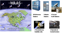
WAAS overview
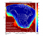
WAAS performances


MSAS/QZSS
The Multi-functional Satellite Augmentation System (MSAS) is the Japanese SBAS. NEC manufactured and delivered MSAS under contract with the Civil Aviation Bureau, Ministry of Land, Infrastructure, Transport and Tourism.
MSAS is operational since 2007 supporting en-route, terminal and non-precision approach operations (RNP 0.1). Recently has completed successful LPV flight trials augmenting GPS L1 signals.
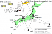
MSAS architecture

QZSS (Quasi-Zenith Satellite System) is the Japanese satellite navigation program with a regional service coverage based on orbits for quasi-zenith satellites to broadcast radio signals from high elevation angle into urban canyons. MSAS evolutions will take advantage of the Japanese QZSS and to include DFMC capabilities in the future[7].
GAGAN
The GPS Aided Geo Augmented Navigation or GPS and Geo Augmented Navigation system (GAGAN) is the SBAS implementation by the Indian government. The Indian government states that it will use the experience of building the GAGAN system in the creation of an autonomous regional navigation system called the Indian Regional Navigational Satellite System (IRNSS).[8]
![GAGAN overview.[8]](/navipedia/images/thumb/c/c1/Gagan_overview.png/182px-Gagan_overview.png)
GAGAN overview.[8]
![GAGAN overview.[8]](/navipedia/index.php?title=File:Gagan_overview.png)
SDCM
The System for Differential Corrections and Monitoring (SDCM) is the SBAS currently being developed in the Russian Federation. SDCM is expected to be certified in the coming years, being this just the first step in the SDCM strategy which pursues also other broadcast means –potentially a polar MEO– with the aim of providing also a service to the North part of Russia.
The main differentiator of SDCM with respect to other SBAS systems is that it is conceived as an SBAS augmentation to GPS and GLONASS, whereas the rest of current SBAS initiatives provide corrections and integrity just to GPS satellites.
- Sdcm overview.png
SDCM planned station network
SNAS/BDSBAS
The People's Republic of China is developing its own SBAS, called Satellite Navigation Augmentation System (SNAS). There is little public information available on this development.
Now, the Chinese SBAS initiatives refer to BeiDou Satellite-based Augmentation System (BDSBAS).

SACCSA
The SBAS initiative in South/Central America and the Caribbean is called SACCSA (Soluciόn de Aumentaciόn para Caribe, Centro y Sudamérica). SACCSA is an ICAO project founded by the Participants/Member States of the SACCSA Project: Argentina, Bolivia, Colombia, Costa Rica, Guatemala, Panama, Spain, Venezuela and COCESNA (Corporación Centroamerica de Servicios de Navegación Aérea). The objective is to study the improvement of the Air Navigation Environment in the Caribbean and South America (CAR/SAM) Regions with a SBAS solution. The program began in 2003 being at present in its Phase III which will determine the feasibility of the implementation of an own SBAS system in the CAR/SAM regions.
ASECNA
ASECNA corresponds to the SBAS for Africa and Indian Ocean Development initiative. It is composed by international public organisations from 18 member states.
ASENCA aims to provide early SBAS services from 2021/2022 for NPA, APV-1 and CAT-I operations. Full DFMC services are expected beyond 2028/2030 for CAT-I autoland operations and potentially further ones[2].
KASS
In October 2014, the Korea Aerospace Research Institute (KARI) was appointed as the leading research organization to develop and build Korea’s own Satellite Based Augmentation System (SBAS), known as KASS (Korea Augmentation Satellite System) in compliance with ICAO Annex 10.
It is expected to provide APV-1 safety-of-life service to airports located in South Korea in 2022[3].
SouthPAN
SouthPAN (Southern Positioning Augmentation Network) is the initiative jointly funded by Australia and New Zealand to develop a SBAS system.
A first SBAS Test-Bed Demonstration trial and economic analysis has been completed, in which different companies (including Lockheed Martin and GMV) were involved. The operational system deployment is expected to start in a short term[10].
References
- ^ GSA User Technology Report 2018
- ^ a b ASECNA status
- ^ a b KAAS status (2019)
- ^ Australian SBAS
- ^ Global SBAS Status, Satellite Based Augmentation System (SBAS), Interoperability Working Group(IWG), June 2014
- ^ a b Wide Area Augmentation System on Wikipedia
- ^ MSAS status and evolutions
- ^ a b GPS Aided Geo Augmented Navigation on Wikipedia
- ^ Springer Open
- ^ SPAN status