If you wish to contribute or participate in the discussions about articles you are invited to contact the Editor
MSAS Space Segment: Difference between revisions
No edit summary |
|||
| Line 16: | Line 16: | ||
The space segment consists of two geosynchronous communication satellites (GEO): the '''Multifunctional Transport Satellites (MTSAT)''', with navigation payloads which broadcast the correction messages generated by the Master Stations for reception by the User segment. These two satellites are not only devoted to navigation, but also to weather purposes. | The space segment consists of two geosynchronous communication satellites (GEO): the '''Multifunctional Transport Satellites (MTSAT)''', with navigation payloads which broadcast the correction messages generated by the Master Stations for reception by the User segment. These two satellites are not only devoted to navigation, but also to weather purposes. | ||
They are geostationary satellites owned and operated by the [http://www.mlit.go.jp Japanese Ministry of Land, Infrastructure and Transport] and the [http://www.jma.go.jp Japan Meteorological Agency (JMA)], and provide coverage for the hemisphere centred on 140° East; this includes Japan and Australia who are the principal users of the satellite imagery that MTSAT provides. They replace the GMS-5 satellite, also known as Himawari 5 | They are geostationary satellites owned and operated by the [http://www.mlit.go.jp Japanese Ministry of Land, Infrastructure and Transport] and the [http://www.jma.go.jp Japan Meteorological Agency (JMA)], and provide coverage for the hemisphere centred on 140° East; this includes Japan and Australia who are the principal users of the satellite imagery that MTSAT provides. They replace the GMS-5 satellite, also known as Himawari 5. They can provide imagery in five wavelength bands — visible and four infrared, including the water vapour channel. The visible light camera has a resolution of 1 km; the infrared cameras have 4 km (resolution is lower away from the equator at 140° East). The spacecraft have a planned lifespan of five years. MTSAT-1 and 1R were built by [http://www.ssloral.com/ Space Systems/Loral]. MTSAT-2 was built by [http://www.mitsubishielectric.com/ Mitsubishi]. <ref>[http://en.wikipedia.org/wiki/Multi-Functional_Transport_Satellite MTSAT in Wikipedia]</ref> | ||
Revision as of 10:58, 5 July 2011
| MSAS | |
|---|---|
| Title | MSAS Space Segment |
| Author(s) | GMV. |
| Level | Basic |
| Year of Publication | 2011 |
The Multi-functional Satellite Augmentation System (MSAS) is the Japanese SBAS System: a GPS Augmentation system with the goal of improving its accuracy, integrity, and availability, and that uses the Multifunctional Transport Satellites (MTSAT). Tests had been accomplished successfully, and MSAS for aviation use was commissioned on September 27, 2007.
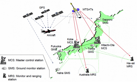
MSAS receives GPS signal at the Ground Monitor Stations and the Monitor & Ranging Stations, checks operational status of GPS, analyze GPS error and ionospheric delay, and then broadcasts augmentation information through MTSAT (Multi-functional Transport Satellite)[1] from the Master Control Stations. Those satellites, MTSAT, broadcast the correction messages back to Earth, where MSAS-enabled GPS receivers use the corrections while computing their positions to improve accuracy.
MSAS Space Segment
The space segment consists of two geosynchronous communication satellites (GEO): the Multifunctional Transport Satellites (MTSAT), with navigation payloads which broadcast the correction messages generated by the Master Stations for reception by the User segment. These two satellites are not only devoted to navigation, but also to weather purposes.
They are geostationary satellites owned and operated by the Japanese Ministry of Land, Infrastructure and Transport and the Japan Meteorological Agency (JMA), and provide coverage for the hemisphere centred on 140° East; this includes Japan and Australia who are the principal users of the satellite imagery that MTSAT provides. They replace the GMS-5 satellite, also known as Himawari 5. They can provide imagery in five wavelength bands — visible and four infrared, including the water vapour channel. The visible light camera has a resolution of 1 km; the infrared cameras have 4 km (resolution is lower away from the equator at 140° East). The spacecraft have a planned lifespan of five years. MTSAT-1 and 1R were built by Space Systems/Loral. MTSAT-2 was built by Mitsubishi. [2]

