|
|
| Line 6: |
Line 6: |
| |YearOfPublication=2011 | | |YearOfPublication=2011 |
| }} | | }} |
| ==Introduction==
| |
| GLONASS satellites transmit right-hand circularly polarised signals centred on two radio-frequencies in L band, referred here to Link 1 (G1) and Link 2 (G2)<ref group="footnotes">We use G1 and G2 instead of L1 and L2 to better differentiate from GPS. Nevertheless, the ICD uses L1 and L2: See [http://rniikp.ru/en/pages/about/publ/ikd51en.pdf this document]</ref>.
| |
|
| |
| [[File:GLONASS signal spectrum.png|none|thumb|400px|alt=GLONASS signal spectrum|'''''Figure 1:''''' GLONASS signal spectrum.]]
| |
|
| |
| Two services are available from GLONASS system:
| |
| * '''SPS:''' The Standard Positioning Service (or Standard Accuracy Signal service) is an open service, free of charge for worldwide users. The navigation signal was initially provided only in the frequency band G1, but from 2004 on the new GLONASS-M transmits also a second civil signal in G2.
| |
| * '''PPS:''' The Precise Positioning Service (or High Accuracy Signal service) is restricted<ref group="footnotes">Although the code P is not encrypted, its unauthorised use is not recommended by the Russian Ministry of Defence because the P-code may be changed without prior notice.</ref> to military and authorised users. Two navigation signals are provided in the two frequency bands G1 and G2.
| |
|
| |
| In contrast to GPS satellites that share the same frequencies, each GLONASS satellite is allocated a particular frequency within the band. This frequency determines the frequency channel number of the satellite<ref group="footnotes">GLONASS relies on the Frequency Division Multiple Access (FDMA) technique to distinguish the satellites instead on the CDMA of GPS.</ref>, and allow user receivers to identify the satellites.
| |
| The actual frequency of transmission can be derived from the channel number k by applying the following expressions:
| |
|
| |
| <math>
| |
| \begin{array}{lcl}
| |
| Frequency \, band \ G1: f1(k) = 1602+k∗ \frac {9}{16} = (2848+k)∗ \frac{9}{16}MHz \\
| |
| Frequency \, band \ G2: f2(k) = 1246+k∗ \frac {7}{16} = (2848+k)∗ \frac{7}{16}MHz
| |
| \end{array}
| |
| </math>
| |
|
| |
| The frequency numbers k were originally envisaged to provide 24 channels, with k = 1,...,24, but according to guidelines of the International Electric Communication Union (MSE), all GLONASS satellites launched after 2005 will use k = −7, . . . , 6. This change was introduced to avoid interference problems with radio astronomy frequency bands and satellite communication services. The reduction from 24 to 12 channels is compensated at setting up, because two satellites in the same orbit transmit in exactly the same frequency but occupying antipodal locations. In this way, they will never be simultaneously in view from any user on the earth surface (nevertheless, space receivers will need to implement discriminating functions to distinguish the satellites).
| |
|
| |
| In this way, two ranging codes, the coarse acquisition C/A (open civil code) and the precise P (military), are modulated into these frequencies together with a navigation message D, using the BPSK method. The C/A and P codes have 1ms and 1sec of period, and chip-widths of 586.7 and 58.67 meters, respectively, being about two times noisier than the GPS ones (see table 1).
| |
|
| |
| As in GPS, the C/A code was initially modulated only on G1, while the military code P is modulated in both carrier frequencies, G1 and G2; however, the new GLONASS-M satellites (from 2004) also transmit the C/A signal in the G2 frequency band. On the other hand, and unlike the GPS, in GLONASS the PRN sequences of such codes are common for all satellites, because the receiver identifies the satellite by its frequency. The use of different frequencies for the satellites (FDMA) makes the GLONASS signals more robust against interference, and on the other hand, the short code lengths helps signal acquisition.
| |
|
| |
| No Selective Availability (i.e., intentional degradation of the standard accuracy signal) is applied in GLONASS, and no P-code encryption has been reported until now. Although the military P code has not been officially published, it has been deciphered by different research groups. Nevertheless, this P-code may be changed by the Russian Ministry of Defence without prior notice.
| |
| The modernisation of GLONASS will add a new third frequency G3 in the ARNS band for the GLONASS-K satellites. This signal will provide a third civil C/A2 and military P2 codes, being especially suitable for Safety-Of-Life applications.
| |
|
| |
| <math>
| |
| \begin{array}{lcl}
| |
| Frequency \, band \, G3 \, (subject\, to\, change): \\
| |
| f 3(k) = 1 204.7040 + k ∗ \frac {423}{1000} = (2 848 + k) ∗ \frac {423}{1000} MHz
| |
| \end{array}
| |
| </math>
| |
|
| |
| [[File:GLONASS signal structure.png|none|thumb|400px|alt=GLONASS signal structure|'''''Table 1:''''' GLONASS signal structure]]
| |
|
| |
| [[File:GLONASS navigation signals.png|none|thumb|400px|alt=GLONASS navigation signals|'''''Table 2:''''' GLONASS navigation signals. All civil signals are provided free of charge for all users worldwide (Open Services). The military are for authorised users. Note: k = 1, . . . , 24 for satellites launched before 2005. Afterwards k = −7,...,6.]]
| |
|
| |
| ==GLONASS Navigation message==
| |
| GLONASS satellites modulate two navigation messages at 50 bps onto the standard (C/A) and high accuracy (P) signals, each message providing the users the necessary information for positioning (parameters to compute GLONASS satellites coordinates, their clock offsets, and various other system parameters). | | GLONASS satellites modulate two navigation messages at 50 bps onto the standard (C/A) and high accuracy (P) signals, each message providing the users the necessary information for positioning (parameters to compute GLONASS satellites coordinates, their clock offsets, and various other system parameters). |
|
| |
|
| Line 58: |
Line 18: |
| The navigation message of the high accuracy signal (P) structure is not officially published, but different research groups decoded it. According with these investigations each satellite transmits a superframe, which is composed of 72 frames, each containing 5 strings of 100 bits. A frame needs 10 seconds to be transmitted, thence the total length of message is 12 minutes. The first three frames contain the ephemeris for the transmitting satellite. | | The navigation message of the high accuracy signal (P) structure is not officially published, but different research groups decoded it. According with these investigations each satellite transmits a superframe, which is composed of 72 frames, each containing 5 strings of 100 bits. A frame needs 10 seconds to be transmitted, thence the total length of message is 12 minutes. The first three frames contain the ephemeris for the transmitting satellite. |
|
| |
|
| ==User domain GLONASS performance==
| |
| No standardised values are published for GLONASS positioning and timing ac- curacy, and the performance can change from different authors (see more details in [Hofmann-Wellenhof et al., 2008]). Table 3 shows the figures for GLONASS Standard Positioning Service (SPS) [United Nations, 2004]. In general, the values published in the literature for the SPS usually agree with the remark<ref group="footnotes">Taken from [http://www.spacetoday.org/Satellites/GLONASS.html www.spacetoday.org]</ref> “This GLONASS system provides accuracy that is better than GPS with S/A on and worse than GPS with S/A off” (notice that S/A is not implemented in GLONASS system).
| |
| [[File:GLONASS Standard Positioning Service.png|none|thumb|200px|alt=GLONASS Standard Positioning Service|'''''Table 3:''''' GLONASS Standard Positioning Service performance according to the document [United Nations, 2004].]]
| |
|
| |
| The information on the Precise Positioning Service (PPS) is not included in table 3 due to the lack of information about this service performance.
| |
|
| |
|
| ==Notes== | | ==Notes== |
| Line 73: |
Line 28: |
|
| |
|
| [[Category:Fundamentals]] | | [[Category:Fundamentals]] |
| | [[Category:GLONASS]] |
| [[Category:GLONASS Signal Structure]] | | [[Category:GLONASS Signal Structure]] |
 Fundamentals Fundamentals
|
| Title
|
GLONASS Navigation Message
|
| Author(s)
|
J. Sanz Subirana, JM. Juan Zornoza and M. Hernandez-Pajares, University of Catalunia, Spain.
|
| Level
|
Basic
|
| Year of Publication
|
2011
|
|
|
GLONASS satellites modulate two navigation messages at 50 bps onto the standard (C/A) and high accuracy (P) signals, each message providing the users the necessary information for positioning (parameters to compute GLONASS satellites coordinates, their clock offsets, and various other system parameters).
The navigation message of the standard accuracy signal (C/A) is broadcast as continuously repeating superframes with a duration of 2.5 minutes. Each superframe consists of 5 frames of 30 seconds, and each frame consists of 15 strings of 2 seconds duration (100 bits length).
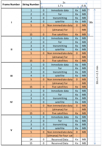
Figure 2: GLONASS navigation message structure (source GLONASS-ICD).
The message content divides the data in immediate data of the transmitting satellite and non-immediate data for the other satellites. The immediate data is repeated in the first four strings of every frame. It comprises the ephemeris parameters, satellite clock offsets, satellite healthy flag and the relative difference between carrier frequency of the satellite and its nominal value. The non-immediate data is broadcast in the strings 5 to 15 of each frame (almanac for 24 satellites). The frames I to IV contain almanac for 20 satellites (5 per frame), and the 5th frame almanac for 4 satellites. The last 2 strings of frame 5 are reserved bits (the almanac of each satellite uses 2 strings).
The ephemerides values are predicted from the Ground Control Centre for a 24 hours period, and the satellite transmits a new set of ephemerides every 30 minutes. These data differ from GPS data. Instead of Keplerian orbital elements, they are provided as Earth Centred Earth Fixed (ECEF) Cartesian coordinates in position and velocity, with lunisolar acceleration perturbation parameters. The GLONASS-ICD [GLONASS ICD, 2008] provides the integration equations based on 4th-order-Runge-Kutta method, which includes the second zonal geopotential harmonic coefficient. The almanac is quite similar to the GPS one, given as modified Keplerian parameters, and it is updated approximately once per day.
The navigation message of the high accuracy signal (P) structure is not officially published, but different research groups decoded it. According with these investigations each satellite transmits a superframe, which is composed of 72 frames, each containing 5 strings of 100 bits. A frame needs 10 seconds to be transmitted, thence the total length of message is 12 minutes. The first three frames contain the ephemeris for the transmitting satellite.
Notes
References
- GLONASS ICD, 2008. Technical report. v.5.1.
- Hofmann-Wellenhof, B., Lichtenegger, H., K. and Wasle, E., 2008. GNSS - Global Navigation Satellite Systems.. Springer-Verlag, Wien, Austria.
- United Nations, 2004 Report of the action team on global navigation satellite systems (GNSS) – Follow up to the Third United Nations Conference on the Exploration and Peaceful Uses of Outer Space (UNISPACE III).
