If you wish to contribute or participate in the discussions about articles you are invited to contact the Editor
EGNOS Performances: Difference between revisions
Gema.Cueto (talk | contribs) No edit summary |
Gema.Cueto (talk | contribs) No edit summary |
||
| (7 intermediate revisions by the same user not shown) | |||
| Line 12: | Line 12: | ||
==EGNOS Performances Requirements== | ==EGNOS Performances Requirements== | ||
EGNOS has been designed to meet SBAS performance requirements for civil aviation operations down to Localizer Performance with Vertical Guidance (LPV) minima but EGNOS service might also be used in a wide range of other application domains (e.g. maritime, rail, road...):<ref name="SOL DEF">[ | EGNOS has been designed to meet SBAS performance requirements for civil aviation operations down to Localizer Performance with Vertical Guidance (LPV) minima but EGNOS service might also be used in a wide range of other application domains (e.g. maritime, rail, road...):<ref name="SOL DEF">[https://www.gsc-europa.eu/sites/default/files/sites/all/files/egnos_sol_sdd_in_force.pdf EGNOS Safety of Life Service Definition Document]</ref><ref name=" EGNOS OS SDD">[https://www.gsc-europa.eu/sites/default/files/sites/all/files/egnos_os_sdd_in_force.pdf EGNOS Open Service Definition Document]</ref> | ||
{| class="wikitable" | {| class="wikitable" | ||
| Line 20: | Line 20: | ||
! colspan="2" | [[Accuracy]] (95%) | ! colspan="2" | [[Accuracy]] (95%) | ||
! colspan="4" | [[Integrity]] | ! colspan="4" | [[Integrity]] | ||
! rowspan="2" | [[Continuity]] | ! rowspan="2" colspan ="2" | [[Continuity]] | ||
! rowspan="2" | [[Availability]] | ! rowspan="2" | [[Availability]] | ||
|- | |- | ||
! Lateral | ! Lateral | ||
! Vertical | ! Vertical | ||
! | ! Integrity | ||
! colspan="3" | TTA | |||
! TTA | |||
|- | |- | ||
! [[EGNOS Open Service|Open Service]] | ! [[EGNOS Open Service|Open Service]] | ||
| Line 34: | Line 32: | ||
| align="center" | 3m | | align="center" | 3m | ||
| align="center" | 4m | | align="center" | 4m | ||
| align="center" | - | | align="center" colspan="2" | - | ||
| align="center" | | align="center" colspan="2" | - | ||
| align="center" colspan ="2"| - | |||
| align="center" | | align="center" | 0.99 | ||
| align="center" | 99 | |||
|- | |- | ||
! [[EGNOS Safety of Life Service| | ! [[EGNOS Safety of Life Service|En-route and NPA]] | ||
| | | |FIRs of ECAC 96 | ||
| align="center" | 220m | | align="center" | 220m | ||
| align="center" | - | | align="center" | - | ||
| align="center" | | align="center" colspan="3" | 1 – 1x10⁻⁷/h | ||
| align="center" | Less than 6 seconds | |||
| align="center" | | | align="center" | <1 – 1x10⁻³ per hour in most of ECAC || <1 – 2.5x10⁻³ per hour in other areas of ECAC | ||
| align="center" | | | align="center" | 0.999 in all ECAC | ||
| | |||
| align="center" | | |||
|- | |- | ||
! [[EGNOS Safety of Life Service| | ! [[EGNOS Safety of Life Service|APV-I & LPV200]] | ||
| Land Masses of ECAC 96 | | Land Masses of ECAC 96 | ||
| align="center" | | | align="center" | 3m | ||
| align="center" | | | align="center" | 4m | ||
| align="center" | | align="center" colspan="3" | 1 – 2x10⁻⁷/approach | ||
| align="center" | Less than 6 seconds | |||
| align="center" | | | colspan="1" align="center" | <1 – 1x10⁻⁴ per 15 seconds in the core of ECAC || 1 –5x10⁻⁴ per 15 seconds in most of ECAC landmasses | ||
| | | align="center" | 0.99 in most of ECAC landmasses | ||
| align="center" | 99 | |||
|} | |} | ||
| Line 70: | Line 62: | ||
==Typical Performances== | ==Typical Performances== | ||
The typical performances provided by EGNOS are presented in the next figures. For the computation, the day 6th December 2018, considered to be a representative day, has been selected. The images have been obtained using gmvBrave tool.<ref name="gmvBrave">[https://www.gmv.com/ | The typical performances provided by EGNOS are presented in the next figures. For the computation, the day 6th December 2018, considered to be a representative day, has been selected. The images have been obtained using gmvBrave tool.<ref name="gmvBrave">[https://www.gmv.com/en/Products/brave/ gmvBrave]</ref> | ||
<gallery widths="500px" heights="300px" perrow="1"> | <gallery widths="500px" heights="300px" perrow="1"> | ||
Image: | Image:EGNOS_availability.jpg|'''Availability:''' The figure shows EGNOS availability map together with the iso-lines of availability compliance to APV-I service level availability requirements (i.e., HPL < 40 m and VPL < 50 m). The period of analysis corresponds to one day with the inner iso-line delimiting the user locations where a service level over 99% availability is achieved. | ||
Image: | Image:EGNOS_continuity.jpg|'''Continuity:''' The figure shows EGNOS continuity map together with the iso-lines of continuity risk compliance to APV-I service level. The continuity risk is computed as the probability of having a continuity event (Protection Levels bigger than Alarm Limits) during a period of 15 seconds provided that the service was available (Protection Levels smaller than Alarm Limits) at the start of the period. The inner iso-line, 1e-4, delimits the user locations which did not have a single continuity event during the analyzed day. | ||
Image: | Image:EGNOS_accuracy.jpg|'''Accuracy:''' The figure shows EGNOS vertical accuracy map together with the iso-lines of 95% Vertical Position Error in metres. Users inside the inner iso-line had a vertical accuracy below 2 m (95%) for the analyzed day. | ||
Image: | Image:EGNOS_integrity.jpg|'''Integrity:''' The figure shows EGNOS vertical integrity margins as maximum Vertical Safety index map (maximum ratio between the vertical user error and the vertical user protection level). All values are under one meaning that no integrity failures at user level were observed. | ||
</gallery> | </gallery> | ||
==Monitoring of EGNOS Performances== | ==Monitoring of EGNOS Performances== | ||
EGNOS performances are being monitored continuously by several entities, such as ESSP<ref name="ESSP EGNOS Perfo">[ | EGNOS performances are being monitored continuously by several entities, such as ESSP<ref name="ESSP EGNOS Perfo">[https://egnos-user-support.essp-sas.eu/new_egnos_ops/ EGNOS performances by ESSP]</ref> and ESA.<ref name="ESA EGNOS Perfo">[http://www.egnos-pro.esa.int/IMAGEtech/imagetech_realtime.html EGNOS performances by ESA]</ref> | ||
The EGNOS performance monitoring done by ESSP<ref name="ESSP EGNOS Perfo"/> includes figures on achieved availability, continuity and integrity. In addition, it forecasts the performances in terms of availability and integrity. | The EGNOS performance monitoring done by ESSP<ref name="ESSP EGNOS Perfo"/> includes figures on achieved availability, continuity and integrity. In addition, it forecasts the performances in terms of availability and integrity. | ||
Latest revision as of 14:15, 18 March 2020
| EGNOS | |
|---|---|
| Title | EGNOS Performances |
| Edited by | GMV |
| Level | Basic |
| Year of Publication | 2011 |

EGNOS (European Geostationary Navigation Overlay Service) is the European satellite-based augmentation service (SBAS) that complements the existing satellite navigation services provided by the US Global Positioning System (GPS) using the L1 C/A signal. EGNOS will augment both GPS and Galileo in the future (in EGNOS V3) using L1 and L5 frequencies.
EGNOS performances are usually described in terms of accuracy, integrity, availability and continuity.
EGNOS Performances Requirements
EGNOS has been designed to meet SBAS performance requirements for civil aviation operations down to Localizer Performance with Vertical Guidance (LPV) minima but EGNOS service might also be used in a wide range of other application domains (e.g. maritime, rail, road...):[1][2]
| Service | Service Coverage | Accuracy (95%) | Integrity | Continuity | Availability | |||||
|---|---|---|---|---|---|---|---|---|---|---|
| Lateral | Vertical | Integrity | TTA | |||||||
| Open Service | EU25 States (plus Norway and Switzerland) land masses | 3m | 4m | - | - | - | 0.99 | |||
| En-route and NPA | FIRs of ECAC 96 | 220m | - | 1 – 1x10⁻⁷/h | Less than 6 seconds | <1 – 1x10⁻³ per hour in most of ECAC | <1 – 2.5x10⁻³ per hour in other areas of ECAC | 0.999 in all ECAC | ||
| APV-I & LPV200 | Land Masses of ECAC 96 | 3m | 4m | 1 – 2x10⁻⁷/approach | Less than 6 seconds | <1 – 1x10⁻⁴ per 15 seconds in the core of ECAC | 1 –5x10⁻⁴ per 15 seconds in most of ECAC landmasses | 0.99 in most of ECAC landmasses | ||
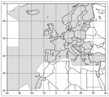
ECAC 96 Flight Information Regions
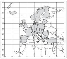
ECAC 96 land masses


Typical Performances
The typical performances provided by EGNOS are presented in the next figures. For the computation, the day 6th December 2018, considered to be a representative day, has been selected. The images have been obtained using gmvBrave tool.[3]
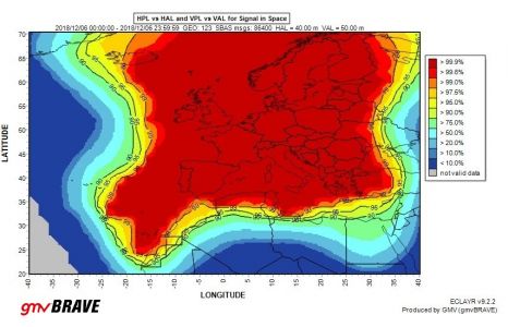
Availability: The figure shows EGNOS availability map together with the iso-lines of availability compliance to APV-I service level availability requirements (i.e., HPL < 40 m and VPL < 50 m). The period of analysis corresponds to one day with the inner iso-line delimiting the user locations where a service level over 99% availability is achieved.
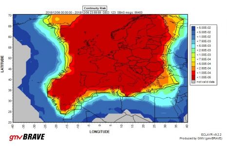
Continuity: The figure shows EGNOS continuity map together with the iso-lines of continuity risk compliance to APV-I service level. The continuity risk is computed as the probability of having a continuity event (Protection Levels bigger than Alarm Limits) during a period of 15 seconds provided that the service was available (Protection Levels smaller than Alarm Limits) at the start of the period. The inner iso-line, 1e-4, delimits the user locations which did not have a single continuity event during the analyzed day.
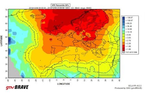
Accuracy: The figure shows EGNOS vertical accuracy map together with the iso-lines of 95% Vertical Position Error in metres. Users inside the inner iso-line had a vertical accuracy below 2 m (95%) for the analyzed day.
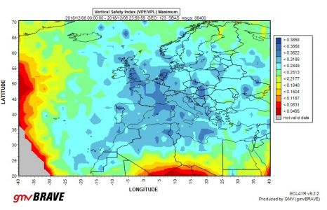
Integrity: The figure shows EGNOS vertical integrity margins as maximum Vertical Safety index map (maximum ratio between the vertical user error and the vertical user protection level). All values are under one meaning that no integrity failures at user level were observed.


Monitoring of EGNOS Performances
EGNOS performances are being monitored continuously by several entities, such as ESSP[4] and ESA.[5]
The EGNOS performance monitoring done by ESSP[4] includes figures on achieved availability, continuity and integrity. In addition, it forecasts the performances in terms of availability and integrity.
The monitoring done by ESA[5] is twofold. On the one hand, the messages, as broadcast by the EGNOS satellites, are analyzed to determine the status of several parameters, such as the GPS satellites which are augmented by EGNOS, the level of monitoring of the ionosphere over Europe or the achieved protection levels. On the other hand, ESA monitoring environment allows to select different reference stations and depicts the accuracy and integrity obtained for those sites.