If you wish to contribute or participate in the discussions about articles you are invited to contact the Editor
EGNOS Data Access Service (EDAS)
| EGNOS | |
|---|---|
| Title | EGNOS Data Access Service (EDAS) |
| Edited by | GMV |
| Level | Basic |
| Year of Publication | 2011 |
EDAS is the technical core of the EGNOS Commercial Data Distribution Service (CDDS) and provides the opportunity to deliver EGNOS data to users who cannot always view the EGNOS satellites (such as in urban canyons) or to support a variety of other value added services, applications and research programs.[1]
In 2006, the European Commission through the GJU (now superseded by the European GNSS Agency, the GSA) commissioned the EDAS system. EDAS allows any registered entity to plug into EGNOS to receive the internal data collected, generated and delivered by EGNOS for free. Although the idea of providing GNSS data streams in real time is far from being new, EDAS has some key differentiators, the most important one is probably the service reliability. Other benefits that EDAS brings are the high data rate (1Hz), the dissemination of the EGNOS message broadcast by each GEO satellite and the provision of GLONASS raw measurements. Additionally EDAS provides the raw data of the Ranging and Integrity Monitoring Stations (RIMS) and Navigation Land Earth Stations (NLES).[1]
EDAS provides ground-based access to EGNOS data, through a collection of services, which are accessible to registered users through the Internet and are oriented to users in different domains of application such as Location Based Services (LBS), a broad range of services in professional GNSS markets, Assisted-GNSS (A-GNSS) concepts, and related R&D activities.[2]
In fact, EDAS to users the possibility to access the EGNOS data even when the Signal In Space (SIS) is not available due to lack of visibility of the satellites (Urban Canyon, Indoor, ...). EDAS was officialy declared available on July 2012. The last release of the Service Definition Document (SDD) is available here.
Since April 2013, four new EDAS Services have been introduced: Data Filtering, FTP, SISNET and NTRIP.[3]
EDAS Overview
The main purpose of EDAS is to provide a basis for new applications beyond those from the nominal EGNOS Open Service and Safety of Life Service. To do so, the objective is to provide an interface point where multiple EGNOS Multimodal Service Providers can obtain the EGNOS products in real-time and within guaranteed delay, security, safety and performance boundaries and also in a historical FTP archive to authorised users. Actually there exists the possibility of binding and long-term service agreements. As a result EGNOS information broadcast through the GEO Signal In Space (SIS) becomes accessible, as well as the EGNOS Ranging, Integrity and Monitoring Stations (RIMS) raw data. EDAS delivers three main types of data in real-time and historic GNSS, via ground transmission systems:
- EGNOS augmentation messages, also transmitted by EGNOS geostationary satellites.
- Raw GPS (L1 and L2), GLONASS L1 and EGNOS L1 geostationary satellites observations and navigation data collected by the entire network of Ranging and Integrity Monitoring Stations (RIMS) and Navigation Land Earth Stations (NLES).
- Differential GNSS (DGNSS) corrections and RTK (RealTime Kinematic) messages for the EGNOS stations allowing users implementing advanced positioning techniques.
EDAS Services
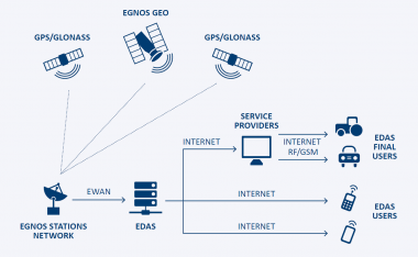
EDAS is not an end-user product. The data streams can be used by Service Providers to generate added value to the final customers by improving the availability and accuracy of the positioning. For instance, one may think of a Service Provider that takes the EGNOS message from EDAS and disseminates it to its customers through the Internet or GPRS.
The EDAS services are classified as Main Data Stream services (Service Level 0, Service Level 1, and Service Level 2) and Added Value Services (Data Filtering, FTP, SISNet and Ntrip).[2]
The main types of data provided by the main data stream Services are:[3]
- Service Level 0 (SL0): it provides data encoded in ASN.1 format. It is recommended for those users willing to transmit data in raw format, or transmit them in a format that allows a complete reconstruction after decoding.
- Service Level 2 (SL2): it is used to transmit data in RTCM 3.1 standard. It includes data from Service Level 1 (decommissioned on 1st July 2014) and an EDAS property message (RTCM Message Number 4085) with additional information (i.e. RIMS status, RIMS APC data, ionospheric and UTC data, etc.).
Appart from the Main Data Stream Services, there are others that provide added value such as:
This service will provide the EGNOS messages in real time using a SISNeT protocol defined by ESA. Since the information is sent by means of an open standard protocol, the users can develop their own application and select which data to retrieve. The full description of this protocol can be found here.
Specific guidelines for the access and usage of the EDAS SISNeT service (EDAS SISNeT – User Information Package) are available at the EDAS specific section of the EGNOS User Support Website.
- EDAS FTP service:
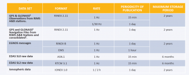
This service provides to the EDAS users EDAS/EGNOS historical data in different formats and data rates. The user is able to access this service through a normal FTP client. Specific guidelines for the access and usage of the EDAS FTP service, including naming conventions and folder structure (EDAS FTP-User Information Package), are available at the EDAS specific section of the EGNOS User Support Website.

- EDAS NTRIP Service:
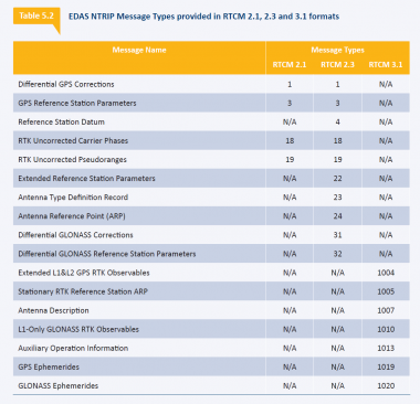
The EDAS-based NTRIP service provides GNSS data (RTCM format) coming from the EGNOS network through the Ntrip protocol in real-time. In fact, EDAS disseminates GNSS data in RTCM 2.1, 2.3 and 3.1. Differential GNSS corrections and phase measurements, as well as additional messages for RTK (real-time kinematic) implementation, are provided within the NTRIP data. NTRIP is an RTCM standard designed for disseminating differential correction data (e.g. in the RTCM-104 format) or other kinds of GNSS streaming data to stationary or mobile users over the Internet, allowing simultaneous PC, laptop, PDA, or receiver connections to a broadcasting host. NTRIP supports wireless Internet access through Mobile IP Networks like GSM, GPRS, EDGE, or UMTS.(EDAS Ntrip – User Information Package) are available at the EDAS specific section of the EGNOS User Support Website.

- EDAS Data Filtering Service:
This service allows EDAS users to access a subset of the Service Level 0 or Service Level 2 data(hence the data are available in ASN1 and RTCM 3.1 formats respectively). The upgraded 2.0 version of the EDAS Client SW makes it possible to select one of the available predefined groups, which are a subset of the EGNOS stations, and the data rate of the received messages. This means that EDAS users can subscribe to a predefined group of RIMS and retrieve data from these sets of stations at 1Hz or 1/30 Hz, thereby reducing the bandwidth consumption and amount of data to be processed on the user side. The list of available groups and information on how to access this EDAS Service can be found in the EDAS Client SW User Manual. Specific guidelines for the access and usage of the EDAS SISNeT service (EDAS SISNeT – User Information Package) are available at the EDAS specific section of the EGNOS User Support Website.
EDAS Architecture

The EDAS architecture is composed of the following elements:
EDAS Client Software (CS): represents the functional interface between the EGNOS Data Server (EDS) and the Service Provider (SP) and it provides authentication, data communication and quota and integrity management
EGNOS Data Server: transforms data received from INSPIRE (a dedicated interface to access to EGNOS data) from the EGNOS proprietary format to ASN.1 (SL0) and RTCM (SL1). For each message received EDS creates one or more RTCM messages and one ASN.1 message. In addition it delivers information to the CS about the status of the messages quota contracted by the SP.
The EDAS architecture is decomposed into two separate elements[2]:
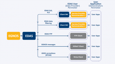
-EDAS system, implementing the interface with the EGNOS infrastructure and performing the necessary data processing to provide the different EDAS Services through Internet. Users can connect directly to EDAS system for some of the services which are based on standard protocols (FTP, SISNET and NTRIP).
-The EDAS Client SW, resident at user level, implementing the external interface of some of the EDAS services (EDAS Service Level 0, Service Level 2 and EDAS Data Filtering Service). The EDAS Client SW is responsible for basic security functions and for the interface with the EDAS system through the appropriate communication means.

The EDAS Client SW is a platform-independent interface element allowing the connection of Users to EDAS system for reception of Main Data Streams. This tool is only available after registration and users make use of it to obtain the EGNOS products in real-time from the EDAS system, then perform the necessary processing and finally provide services to end users via non-GEO means. Moreover, it is in charge of handling the connection between users and EDAS for the Main Data Streams and the Data Filtering Services, through a specific protocol (internal to EDAS and not available to the general public).
EDAS also contains a Man Machine Interface (MMI) for daily operations, monitoring and control. All the elements (but the operator MMI) have redundancy in order to have high availability in the system. On top of that, security is an issue due to the fact that EDAS is connected to the heart of the EGNOS system and, in order to face it, EDAS has been protected and audited against intentional and unintentional attacks.[1]
EDAS users and/or application Providers will be able to connect to EDAS, and directly exploit the EGNOS products or offer added-value services based on EDAS data to final customers.
EDAS Performance
This section presents the EDAS Services performance in terms of availability and latency:
- Availability: percentage of the time in which an EDAS service is delivering data according to specifications. The availability of EDAS services is measured at the EDAS system output (excluding external network performance).[2]
- Latency: time elapsed since the transmission of the last bit of the navigation message from the space segment (EGNOS and GPS/GLONASS satellites) until data leave the EDAS system (formatted according to the corresponding service level specification). EDAS latency is a one way parameter defined for real-time services.[2]
EDAS Services Availability
The following table provides the minimum monthly availability of the EDAS services.
| SL0 | SL2 | SISNet | FTP | Data Filtering | Ntrip | |
|---|---|---|---|---|---|---|
| EDAS Services Availability | 98.5% | 98.5% | 98% | 98% | 98% | 98% |
It should be noted that EDAS service availability performance is nominally higher than the above figures.
EDAS Services Latency
The following table provides the maximum monthly latency (percentile 95) of the EDAS services.
| SL0 | SL2 | SISNet | FTP | Ntrip | Data Filtering | ||
|---|---|---|---|---|---|---|---|
| SL0 | SL2 | ||||||
| EDAS Services Latency | 1.3 s | 1.450 s | 1.150 s | N/A | 1.75 s | 1.6 s | 1.75 s |
It should be highlighted that EDAS services latency performance is nominally lower than the above figures.
EDAS Connections
Access to the EDAS data is possible by one of the two following means:[4]
- Internet connection allowing full transmission of all data on best-effort basis (no latency and data integrity guarantee).
- Higher performance point-to-point (PTP) direct link to the EDAS Server.
The standard and easiest way to receive EDAS is over the internet. Simply by downloading the client software, EDAS can be received through a typical broadband internet connection, where:
- ASN.1 format service requires 600kb/s.
- RTCM format service requires 300kb/s.
- Both formats can be received at 900kb/s.
It is possible to obtain a dedicated faster connection. This might require a fixed line solution providing a dedicated line for each user. The costs for introducing the fixed line solution to EDAS need to be covered by the user, but assistance and support in setting up the connection is provided.
EDAS Based Applications
Given the potential of the architecture deployed by EDAS, the diversity of data provided and its suitability for a wide range of environments and domains, it offers multiple opportunities for harnessing EDAS to provide applications and services,[5] specially for Redistribution of EGNOS augmentation messages and professional GNSS Services.
EDAS has proved to play a role within the identified market segments considered in the EGNOS CDDS. There is a continuously growing EDAS user community and there are a wide range of applications that provide EDAS-based services that comprise the CDDS. Furthermore, the EDAS-N project examined how the current EGNOS Data Access Service (EDAS) should evolve to meet user needs between 2020 and 2030. On the basis of its analysis, it proposes 8 new EDAS services. As EDAS is expected to disseminate EGNOS V3 data over this period, the analysis focuses on what additional features could help generate new EDAS services for users and service providers. The EDAS-N project defined how the current EGNOS EDAS should evolve to meet more demanding user needs between 2020 and 2030. The analysis looked at potential new EDAS services and their market uptake. It also estimated their capital expenditure and operating expense. The project proposed a final set of 8 new EDAS-based services, and defined their implementation schedule. The uptake of the next generation of EDAS is estimated at 178 direct users (mainly service providers) and 350,000 indirect users by 2030. [6]
Notes
References
- ^ a b c The EGNOS Service to Provide Ground Based Access to EGNOS – EDAS Beta test findings; Reinhard Blasi, GSA; Rafael Cardoso-Herce, Didier De Greef, ESSP; José Ramón López-Pérez, Francisco J. Jiménez-Roncero, AENA; Ángel Gavín-Alarcón, GMV; Monica Pesce, VVA; Proceedings of the 23rd International Technical Meeting of The Satellite Division of the Institute of Navigation (ION GNSS 2010), Portland, OR, September 2010
- ^ a b c d e f g h i EGNOS EDAS SDD
- ^ a b EDAS Services
- ^ EDAS Connection
- ^ EDAS Applications
- ^ EGNOS Data Access Service

