If you wish to contribute or participate in the discussions about articles you are invited to contact the Editor
EGNOS Architecture: Difference between revisions
m (Included editor logo.) |
mNo edit summary |
||
| Line 61: | Line 61: | ||
==EGNOS User Segment== | ==EGNOS User Segment== | ||
The [[EGNOS User Segment | EGNOS User Segment]] consists of the GPS receivers. It is important to bear in mind that a GPS receiver only monitors signals sent by the satellites and does not establish any contact with them. Therefore, a GPS receiver cannot be used by a third party to find out a user’s position without his knowledge.<ref name=" USER GUIDE FOR EGNOS APPLICATION DEVELOPERS">[ | The [[EGNOS User Segment | EGNOS User Segment]] consists of the GPS receivers. It is important to bear in mind that a GPS receiver only monitors signals sent by the satellites and does not establish any contact with them. Therefore, a GPS receiver cannot be used by a third party to find out a user’s position without his knowledge.<ref name=" USER GUIDE FOR EGNOS APPLICATION DEVELOPERS">[https://ec.europa.eu/commission/index_en USER GUIDE FOR EGNOS APPLICATION DEVELOPERS ]</ref> | ||
To receive EGNOS signals an EGNOS compatible receiver is required. There are many receivers available on the market from a variety of manufacturers. | To receive EGNOS signals an EGNOS compatible receiver is required. There are many receivers available on the market from a variety of manufacturers. | ||
Revision as of 13:17, 27 July 2018
| EGNOS | |
|---|---|
| Title | EGNOS Architecture |
| Edited by | GMV |
| Level | Basic |
| Year of Publication | 2011 |
The goal of EGNOS (European Geostationary Navigation Overlay Service) is to augment the GPS in order to improve the navigation performances in terms of accuracy and integrity (with the required levels of availability and continuity of service) over the European Civil Aviation Conference (ECAC) Region and to be expandable over neighboring regions.
These augmentations are obtained by providing orbit and clock corrections for GPS satellites and also to correct the ionospheric delays affecting the signal paths to the users. The complex message broadcast by EGNOS GEOs also include Integrity data which allow to bound the remaining errors with a high level of confidence. EGNOS has deployed its Advanced Operational Capability (AOC) using two existing INMARSAT-III navigation transponders (AOR-E and IOR-W) plus a navigation transponder on board of Artemis satellite.[1]
The EGNOS architecture is very complex and highly redundant. It is composed by more than 40 elements deployed in more than 20 countries. EGNOS has been designed to meet the international SBAS standards and performs the following tasks:
- Collect GPS/GLONASS/GEO signals and data.
- Estimate the integrity data and WAD (Wide Area Differential) corrections for the service area.
- Transmit to the users, via the GEO satellites, a GPS-like signal, augmented with integrity and correction messages.
- Verify the correctness of these integrity and correction messages.
Architecture Overview
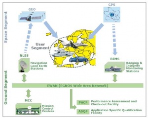
The EGNOS system is directly decomposed in its four segments, a Ground Segment, a Space Segment, and a User segment:[2]
- The Ground Segment computes precise differential corrections and integrity bounds and makes all these information available to users through a broadcast by the Space Segment.
- The Space segment, using three GEO satellites, provides redundant data transmission channel to broadcast toward EGNOS user messages containing differential corrections with the associated integrity information.
- The User Segment is made of EGNOS receivers which enable EGNOS users to accurately compute their position.
- The Support Segment contains off-line facilities supporting activities such as performance analysis, troubleshooting, maintenance and qualification.
EGNOS Space Segment
The EGNOS Space Segment comprises 3 GEO satellites broadcasting corrections and integrity information for GPS satellites in the L1 frequency band (1575,42 MHz). This configuration provides a high level of redundancy over the whole service area in case of a geostationary satellite link failure. The EGNOS operations are handled in such a way that, at any point in time, typically two of the three GEOs broadcast an operational signal. Since it is only necessary to track a single GEO satellite link to benefit from the EGNOS SoL, this secures a switching capability in case of interruption and ensures a high level of continuity of service.
It is intended that the EGNOS space segment will be replenished over time in order to maintain a similar level of redundancy. The exact orbital location of future satellites may vary, though this will not impact the service offered to users. Similarly, different PRN code numbers may be assigned to future GEOs. However, all SBAS user receivers are designed to automatically detect and use any code in a pre-allocated set reserved for SBAS. Such evolutions will therefore be transparent for end users and will not necessitate any human intervention or change of receiving equipment.
EGNOS Ground Segment
The EGNOS Ground Segment comprises a network of Ranging Integrity Monitoring Stations (RIMS), four Mission Control Centers (MCC), six Navigation Land Earth Stations (NLES), and the EGNOS Wide Area Network (EWAN). Two additional facilities are also deployed as part of the ground segment to support system operations and service provision, namely the Performance Assessment and Checkout Facility (PACF) and the Application Specific Qualification Facility (ASQF), which are operated by the EGNOS Service Provider (ESSP SAS).[3]
The EGNOS system is a widely distributed and redundant system. Data flows from one subsystem to another subsystem have different level of criticality.
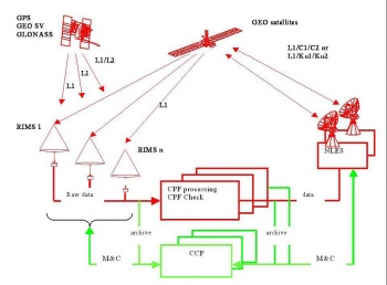
The main EGNOS functions are carried out by the Ground Segment through the following critical subsystems: the RIMS stations, the CPF units and the NLES stations. The Ground Segment is a periodic synchronous and pipelined system. The synchronization of subsystems located in widely separated geographic places is referred to the GPS time by means of GPS receivers providing a 1 PPS (one Pulse Per Second) synchronization pulse to the associated subsystem.
Another feature of the EGNOS Ground Segment is that all Monitoring and Control (M&C) functions performed by humans (non automatic functions) are centralized and implemented in the CCF subsystems, which is outside of the critical data flow. Operators on duty in another CCF (hot backup) are ready to take over the system monitoring and control if the master CCF fails. Remaining two CCF (cold backup) can be reactivated if the master one fails.
In the EGNOS data flow representation, the real time critical data flow is indicated in red whereas the non-critical data flow is indicated in green.
The sub-systems involved in the processing of the critical data are responsible for the achievement of the main EGNOS system performance (accuracy, integrity, continuity, time to alarm, and service coverage) while the sub-systems involved in the management of non-critical data perform the Monitoring and Control (M&C) and archive functions.
The EGNOS Ground Segment includes the following support facilities:
- PACF: Performance Assessment and Check-out Facility, provides support to EGNOS management in such area as performances analysis, troubleshooting, operational procedures as well as upgrade of specification and validation, and support to maintenance.
- ASQF: Application Specific Qualification Facility provides civil aviation and aeronautical certification authorities with the tools to qualify validate and certify the different EGNOS applications.
EGNOS User Segment
The EGNOS User Segment consists of the GPS receivers. It is important to bear in mind that a GPS receiver only monitors signals sent by the satellites and does not establish any contact with them. Therefore, a GPS receiver cannot be used by a third party to find out a user’s position without his knowledge.[4]
To receive EGNOS signals an EGNOS compatible receiver is required. There are many receivers available on the market from a variety of manufacturers. An EGNOS receiver is like a GPS receiver but with special software inside that allows the receiver to lock onto the code used by the EGNOS satellites and compute the EGNOS corrections to the GPS signals. Apart from this, an EGNOS receiver is just like a GPS receiver. This means that it can pick up GPS signals as well. An EGNOS receiver is the same size as a GPS receiver and uses the same type of antenna.[5]
To test the EGNOS receiver, special prototypes have been developed with extensive capabilities to log and analyze data.
Notes
References
- ^ The EGNOS System Architecture explained; Didier Flament, Jean Poumailloux, Jean-Louis Damidaux, Stéphane Lannelongue Alcatel Alenia Space, France ; Javier Ventura-Traveset, P. Michel and C. Montefusco ; European Space Agency, EGNOS Project Office;
- ^ EGNOS Safety of Life (SoL) Service Definition Document (SDD)
- ^ ESSP HomePage
- ^ USER GUIDE FOR EGNOS APPLICATION DEVELOPERS


