If you wish to contribute or participate in the discussions about articles you are invited to contact the Editor
Category:Illustration
Jump to navigation
Jump to search
Media in category "Illustration"
The following 124 files are in this category, out of 124 total.
-
 02947A4.jpg 2,040 × 3,055; 1.03 MB
-
 1104507 70670260.jpg 1,920 × 2,560; 1.27 MB
-
 A.jpg 1,440 × 810; 325 KB
-
 Airplane GPS.jpg 2,048 × 1,536; 743 KB
-
 Ais dcu bridge.jpg 2,028 × 1,290; 531 KB
-
 ATV-JKepler OverSouthofFrancewithoutlasers.jpg 1,500 × 1,061; 563 KB
-
 Augmented GeoTravel.jpg 1,360 × 768; 518 KB
-
 Autobahn-elbtunnel hg.jpg 2,534 × 1,863; 466 KB
-
 Bb block.png 1,190 × 389; 26 KB
-
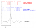 Bb corr.png 688 × 535; 39 KB
-
 BMW Assist Button.jpg 350 × 251; 49 KB
-
 Camera GPS.jpg 940 × 823; 212 KB
-
 Car navigator in action.JPG 1,200 × 900; 662 KB
-
 CompassApplication.jpg 258 × 180; 11 KB
-
 Corr auto psd.png 1,100 × 442; 158 KB
-
 Corr block.png 783 × 318; 18 KB
-
 Corr prn.png 649 × 512; 86 KB
-
 CRS reference system.png 714 × 561; 15 KB
-
 Ddp example.png 1,051 × 524; 27 KB
-
 Ddp extrapol.png 772 × 373; 12 KB
-
 Ddp sequence.png 861 × 464; 24 KB
-
 Dll performance.png 1,194 × 479; 140 KB
-
 Dll principle.png 1,181 × 392; 130 KB
-
 DOP effect in positioning.png 768 × 248; 51 KB
-
 DPL V3 wireless s no pen.JPG 282 × 311; 18 KB
-
 Dsp block.png 1,202 × 319; 25 KB
-
 ECDISTA.jpg 1,205 × 1,346; 307 KB
-
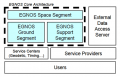 EGNOS Architecture.png 473 × 302; 48 KB
-
 EGNOS Logo.png 404 × 136; 31 KB
-
 EGNOS vehicle tracing.jpg 984 × 820; 317 KB
-
 Example.jpg 400 × 267; 60 KB
-
 Fault tree allocation for SBAS.jpg 551 × 369; 41 KB
-
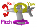 Flight dynamics with text.png 2,048 × 1,536; 720 KB
-
 Fll performance.png 1,182 × 471; 98 KB
-
 Friends2.jpg 2,400 × 1,714; 1.31 MB
-
 Front end.png 1,179 × 332; 23 KB
-
 Galileo 01 wp02.jpg 1,024 × 768; 126 KB
-
 Galileo 02 wp02.jpg 1,024 × 768; 131 KB
-
 Galileo 02 wp04.jpg 1,024 × 768; 143 KB
-
 Galileo Art.png 594 × 426; 313 KB
-
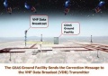
 Galileo Ground Segment.png 590 × 480; 137 KB
-
 Galileo Navigation Message Structure.png 1,137 × 648; 22 KB
-
 Galileo satellite system.jpg 3,020 × 2,141; 580 KB
-
 Galileo Signals in Space.png 2,978 × 3,337; 1.83 MB
-
 Galileo Space Segment.jpg 2,854 × 2,141; 312 KB
-
 Garmin eTrex Legend C in hand.jpg 3,035 × 2,469; 1.65 MB
-
 Garmin Forerunner 205.jpg 3,072 × 2,048; 1.49 MB
-
 Garmin G1000 Diamond DA-42.jpg 1,166 × 778; 709 KB
-
 Garminetrexh.jpg 2,304 × 3,072; 1.04 MB
-
 Gathers VXH-072CV.jpg 2,813 × 1,584; 551 KB
-
 Generic Receiver Architecture.PNG 628 × 49; 4 KB
-
 Generic Receiver.jpg 1,108 × 916; 241 KB
-
 GenericRx.png 1,155 × 272; 696 KB
-
 Geocaching.png 1,000 × 1,000; 39 KB
-
 Geolocation.png 1,536 × 1,131; 406 KB
-
 Glidercockpit.JPG 1,188 × 1,244; 99 KB
-
 GLONASS signal spectrum.png 943 × 606; 196 KB
-
 GLONASSavailability.jpg 880 × 520; 168 KB
-
 GNSS Augmentation Comparison.png 569 × 370; 38 KB
-
 GNSS navigational frequency bands.png 931 × 510; 67 KB
-
 GoCarBarcelona.jpg 2,812 × 2,126; 1.59 MB
-
 Google Maps 2.0 and Moto Q9h.jpg 1,536 × 2,048; 347 KB
-
 GPS on smartphone cycling.JPG 2,272 × 1,704; 715 KB
-
 GPS Satellite NASA art-iif.jpg 1,006 × 806; 111 KB
-
 GPS signal modernization.png 944 × 709; 152 KB
-
 GPStracker GlobalSatTR203.jpg 500 × 500; 81 KB
-
 Ground Station Fucino (ESA).jpg 1,816 × 605; 349 KB
-
 GvSIG - GIS.jpg 1,280 × 770; 607 KB
-
 Hands-free Driving.jpg 2,487 × 1,782; 1.05 MB
-
 Heterodyne vs homodyne.png 1,326 × 901; 141 KB
-
 Int 1 1.png 506 × 413; 16 KB
-
 Integrations.png 1,055 × 825; 60 KB
-
 Integrity-integrity-failure.jpg 402 × 400; 95 KB
-
 Integrity-protection-level.jpg 448 × 580; 49 KB
-
 Jason1.png 660 × 240; 46 KB
-
 Laas step1.jpg 415 × 274; 14 KB
-
 Laas step2.jpg 415 × 291; 27 KB
-
 Laas step3.jpg 415 × 292; 18 KB
-
 Laas step4.jpg 415 × 304; 23 KB
-
 Landsat5.jpg 550 × 399; 49 KB
-
 Mc auto.png 647 × 528; 71 KB
-
 Mc block.png 742 × 436; 25 KB
-
 Mc replicas.png 559 × 447; 16 KB
-
 Multi Function Display Garmin G1000.jpg 1,094 × 821; 822 KB
-
 Navigation Message.png 1,132 × 665; 24 KB
-
 Navit Android.jpg 1,200 × 900; 131 KB
-
 Nyquist and aliasing.png 2,363 × 2,808; 227 KB
-
 P1040916.JPG 2,000 × 1,500; 910 KB
-
 Passive hydrogen maser clock.jpg 300 × 400; 16 KB
-
 Pll performance.png 1,130 × 435; 84 KB
-
 Pll principle.png 706 × 475; 14 KB
-
 Poseidon.graphic.jpg 652 × 527; 66 KB
-
 Proba-3.jpg 1,500 × 1,125; 386 KB
-
 Pteryx UAV - wiki.jpg 640 × 871; 42 KB
-
 Quantization degradation.png 722 × 638; 154 KB
-
 Quantization.png 1,106 × 447; 31 KB
-
 Road Features Examples.png 681 × 723; 455 KB
-
 Rubidium clock.jpg 400 × 344; 23 KB
-
 SBAS Message format.jpg 605 × 155; 44 KB
-
 September 26, 2007 accident, highway 9, CT, flipped truck.jpg 3,000 × 2,000; 1.68 MB
-
 Signal.png 770 × 658; 18 KB
-
 SISA and SISMA illustration concept.png 730 × 344; 31 KB
-
 Srx-10.jpg 448 × 336; 33 KB
-
 Strip coal mining.jpg 768 × 512; 237 KB
-
 Surveying in Pencoed.jpg 2,048 × 1,536; 628 KB
-
 Tl block.png 933 × 518; 31 KB
-
 Tl loopResponse.png 702 × 553; 114 KB
-
 Tolling Process.png 900 × 514; 10 KB
-
 Trafic control center.jpg 986 × 668; 120 KB
-
 Trail on a location-based game.jpg 795 × 532; 134 KB
-
 Train 400.jpg 400 × 315; 27 KB
-
 Transformations between CRF and TRF frames.png 734 × 394; 18 KB
-
 Travelbug-GPSr.jpg 640 × 472; 94 KB
-
 Treo 650 TomTom Navigator.jpg 1,932 × 2,580; 764 KB
-
 Tresco 3D AIS.JPG 1,280 × 994; 173 KB
-
 TRS reference system.png 705 × 566; 17 KB
-
 Unknown Offset 2.png 736 × 493; 64 KB
-
 Unknown Offset.png 918 × 694; 93 KB
-
 Unknown Offset3.png 869 × 576; 96 KB
-
 Unknown Offset4.png 910 × 579; 113 KB
-
 US Navy 020214-M-7370C-034 UAV.jpg 1,720 × 1,160; 646 KB
-
 UT1-UTC and leap seconds adjustments.png 360 × 252; 20 KB
-
 Venueinfo.png 320 × 480; 29 KB
-
 VTS-Hki-emasalo-ows.jpg 633 × 489; 30 KB


.jpg)