If you wish to contribute or participate in the discussions about articles you are invited to contact the Editor
BeiDou User Segment: Difference between revisions
| Line 31: | Line 31: | ||
[[GNSS Applications|GNSS applications]] are all those applications that use GNSS signals to collect position, velocity and time information to be used by the application. For instance, the position and velocity provided by a COMPASS user terminal may be used for different kinds of applications (civil, military, scientific) such as<ref name=BEIDOU_MUNICH_2011/>: | [[GNSS Applications|GNSS applications]] are all those applications that use GNSS signals to collect position, velocity and time information to be used by the application. For instance, the position and velocity provided by a COMPASS user terminal may be used for different kinds of applications (civil, military, scientific) such as<ref name=BEIDOU_MUNICH_2011/>: | ||
* Fishery: | * Fishery: fishermen safety, oceanic and economic security, protection of sovereignty and resources: 14000 fisher users were reported and more than 500 vessel rescue and costal alarm systems have been equipped with BeiDou terminals; | ||
* Disaster Prevention and Mitigation: improvement of rescue response and decision-making capability due to rapid and timely disaster alert, rescue command scheduling and rapid | * Disaster Prevention and Mitigation: improvement of rescue response and decision-making capability due to rapid and timely disaster alert, support to rescue operations regarding command scheduling and rapid communication. BeiDou terminals were used in the operations that followed the earthquakes in Wenchuan (Sichuan Province) and Yushu (Qinghai Province); | ||
* Timing: Beidou/GPS multi-mode time synchronization devices | * Timing: Beidou/GPS multi-mode time synchronization devices, with a reported synchronization accuracy better than 100 ns; | ||
* Other applications include | * Other applications include transportation, water management, meteorology, forest fire prevention, soil monitoring and coal mine safety monitoring. | ||
Revision as of 23:10, 29 November 2011
| COMPASS | |
|---|---|
| Title | BeiDou User Segment |
| Author(s) | GMV |
| Level | Basic |
| Year of Publication | 2011 |
The Compass Navigation Satellite System (CNSS), also named BeiDou-2,[1] is China’s second-generation satellite navigation system that will be capable of providing positioning, navigation, and timing services to users on a continuous worldwide basis[1][2]. With continuous efforts put on compatibility and interoperability of the system, the COMPASS user segment and respective applications are expected to be very similar to all other GNSSs for the open service. COMPASS has one particularity over all the other GNSSs: the capability of allowing exchange of short message services between ground stations and users.
COMPASS User Segment
The COMPASS User Segment consists of COMPASS/Beidou user terminals[3], which receive Compass navigation signals, determine pseudoranges (and other observables) and solve the navigation equations in order to obtain their coordinates. A COMPASS receiver is a device capable of determining the user position, velocity and precise time (PVT) by processing the signal broadcasted by COMPASS satellites. Any navigation solution provided by a GNSS Receiver is based on the computation of its distance to a set of satellites, by means of extracting the propagation time of the incoming signals traveling through space at the speed of light, according to the satellite and receiver local clocks[4]. It should be noted that in the first version of the system, BeiDou-1, the user position was computed by the ground station and relayed back to the user via GEO satellite.
In June 2011, the system has completed the ground segment commissioning, including the test section of the user terminal development[5]. The first generation of BeiDou-1 terminals emerged in 2003 with full Radio Determination Satellite Service (RDSS) functionality and communication terminal based on General Purpose ICs. The second generation appeared in 2009 based in ASIC and comprising already GPS integration[6].
There is also an international cooperation in terms of Compatibility and Interoperability between BeiDou and other GNSSs[3]. The BeiDou ICD Document (V1.0) is expected to be published in 2011[7].
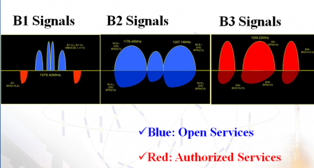
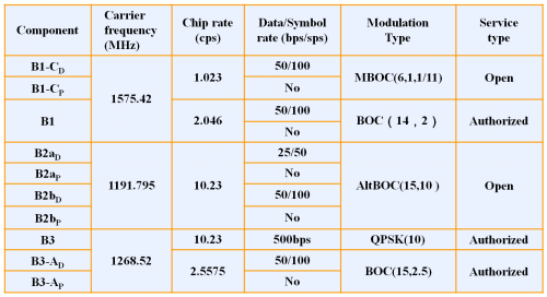
For completeness, the main characteristics of COMPASS signals are shown in the following table and figure, extracted from the presentation on the status of COMPASS in Munich Satellite Navigation Summit 2011 by the China Satellite Navigation Office:[3]
Applications
GNSS applications are all those applications that use GNSS signals to collect position, velocity and time information to be used by the application. For instance, the position and velocity provided by a COMPASS user terminal may be used for different kinds of applications (civil, military, scientific) such as[3]:
- Fishery: fishermen safety, oceanic and economic security, protection of sovereignty and resources: 14000 fisher users were reported and more than 500 vessel rescue and costal alarm systems have been equipped with BeiDou terminals;
- Disaster Prevention and Mitigation: improvement of rescue response and decision-making capability due to rapid and timely disaster alert, support to rescue operations regarding command scheduling and rapid communication. BeiDou terminals were used in the operations that followed the earthquakes in Wenchuan (Sichuan Province) and Yushu (Qinghai Province);
- Timing: Beidou/GPS multi-mode time synchronization devices, with a reported synchronization accuracy better than 100 ns;
- Other applications include transportation, water management, meteorology, forest fire prevention, soil monitoring and coal mine safety monitoring.
Notes
References
- ^ a b Compass Satellite Navigation System (Beidou), on Sinodefence.com, updated on August 6th, 2011.
- ^ COMPASS Navigation system in Wikipedia
- ^ a b c d China Satellite Navigation Office, Development of BeiDou Navigation Satellite System, Munich Satellite Navigation Summit, 2011.
- ^ J. Sanz Subirana, JM. Juan Zornoza and M. Hernández-Pajares, Global Navigation Satellite Systems: Volume I: Fundamentals and Algorithms
- ^ Compass system 10 months to complete a comprehensive test covering the Asia Pacific region next year China news, 20th June 2011.
- ^ "Status of COMPASS Development", M. Lu, Stanford PNT Symposium 2010
- ^ "Development of BeiDou Navigation Satellite System", China Satellite Navigation Office, ION GNSS September 2011


