If you wish to contribute or participate in the discussions about articles you are invited to contact the Editor
AIS-VTS
| Applications | |
|---|---|
| Title | AIS-VTS |
| Author(s) | GMV. |
| Level | Medium |
| Year of Publication | 2011 |
The Automatic Identification System (AIS) is perhaps the biggest technological advance in maritime navigation, since the introduction of radar. The service is a shipboard broadcast system that acts like a transponder, operating in the VHF maritime band and transmitting real time information of the vessel, in a similar manner as ADS-B [1] for aviation. In the same way as ADS-B, the AIS relies on GNSS as primary positioning source.
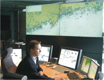
The Vessel Traffic Service (VTS) provides active monitoring and navigational advice for vessels in particularly confined and busy waterways.[1] Usually the VTS integrates in a command and control room, information from sources such as radar, AIS and closed circuit television sites.
Application Architecture
AIS Architecture
The AIS is endorsed by the International Maritime Organization and was originally developed as a collision avoidance tool to enable commercial vessels to get awareness of each other more clearly in all conditions and improve information about his surrounding environment. Nowadays is also used for vessel traffic control around busy seaways. The onboard system uses a transponder system that operates in the VHF maritime band and continuously transmits vessels identity, geographic position, speed, course, vessel type, and cargo information along with other relevant information to all other AIS equipped vessels within range, in a real-time automated manner.
This service is not only vital for navigation, but is increasingly used to enhance the security of ports and waterways by providing governments with greater situational awareness of commercial vessels and their cargo. All international ships over 300 tonnes, cargo vessels over 500 tonnes and passenger carriers of every size are mandated to carry Automatic Identification System (AIS) transponders providing constantly-updated identification and navigation data.[2]
GNSS information is embedded within AIS transmission, providing a concise awareness information, which can be displayed automatically in the electronic charts applications. The safety and security of vessels using this system is significantly enhanced.[3]
With augmentation systems, GNSS accuracy will meet the requirements for navigation in harbor entrances and approaches or other waters in which navigation is restricted,[4] increasing accuracy, availability, and integrity for all users.
The GNSS receivers for AIS are considered safety critical applications.
VTS Architecture
The need for accurate position information becomes even more critical as the vessel departs from or arrives in port. Vessel traffic, congested harbors, congested waterways and other hazards make manoeuvring more difficult, and the risk of accidents becomes greater.[3]
The AIS service is combined with a shore station, offering port authorities and maritime safety bodies the ability to manage maritime traffic and reduce the hazards of marine navigation in approaches of Ports and Inland Waterways.
There are two main types of VTS, surveilled and non-surveilled. Surveilled systems consist of one or more land-based sensors such as radar, AIS and closed circuit television sites, which output their signals to a central location where operators monitor and manage vessel traffic movement. Non-surveilled systems consist of one or more reporting points at which ships are required to report their identity, course, speed, and other data to the monitoring authority. The VHF-FM communications network is the basis of most VTS services.
VTS plays a more significant role in marine traffic management, decreasing vessel congestion, critical encounter situations and the probability of a marine casualty resulting in environmental damage, due to a computer-assisted tracking, similar to that used in air traffic control, that combines information from radars network, AIS and close circuit television cameras for surveillance.[1]
Application Characterization
AIS Characterization
The AIS uses Self-Organizing Time Division Multiple Access (SOTDMA) technology to meet a high broadcast rate and ensure reliable ship-to-ship operation.[1]
The Vessel Traffic Service receives awareness information from the AIS, however the AIS provides in first place a Collision avoidance service. AIS also have the ability to send Aids to navigation and Search and Rescue messages.
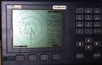
The AIS transponders send data every 2 to 10 seconds depending on a vessel’s speed while underway, and every 3 minutes while vessels are at anchor. These data include:[1]
- The vessel’s Maritime Mobile Service Identity (MMSI), a unique, identification number,
- Navigation status (at anchor, under way using engine(s), or not under command),
- Rate of turn – right or left, 0 to 720 degrees per minute;
- Speed over ground,
- Position accuracy,
- Longitude and Latitude,
- Course over ground,
- True Heading and
- Time stamp (UTC, time accurate to nearest second when this data was generated).
In addition, the following data are broadcast every 6 minutes whether underway or at anchor:
- International Maritime Organization’s ship identification number that remains unchanged upon transfer of the ship’s registration to another country,
- International radio call sign, assigned to the vessel by its country of registry,
- Vessel Name,
- Type of ship/cargo,
- Dimensions of ship,
- Type of positioning system (GPS, DGPS or LORAN-C),
- Location of positioning system’s antenna onboard the vessel,
- Draught of ship (0.1 meter to 25.5 meters),
- Destination and
- Estimated time of arrival (ETA) at destination.
Satellite AIS
The AIS system enables port authorities and coast guards to track seagoing traffic, but its VHF signals are only available within coastal zones or on a ship-to-ship basis[2], due to the short horizontal range coastal traffic system. It is not possible to communicate outside the AIS range, which is typically of about 40 nautical miles (74 kilometers). The range varies due to many factors, like weather conditions for instance.[5]
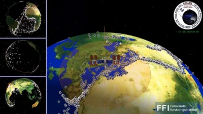
However the signal strength is enough to be received on a satellite. In fact, AIS propagates much further vertically – all the way up to Earth orbit, where they can be picked up by satellites. This fact offers a mean to fill in current AIS blind spots in the open ocean. This data can be transmitted to ground stations and enhance the coverage capabilities of AIS.
To verify the concept of an operational AIS-detecting satellite constellation, ESA has installed an AIS antenna outside Columbus module in the International Space Station[6]. This antenna is used by a pair of experimental receivers on an alternating three-monthly basis.
VTS Characterization
According with SOLAS statement on Safety of Navigation, VTS contributes to safety of life at sea, safety and efficiency of navigation and protection of the marine environment, adjacent shore areas, work sites and offshore installations from possible adverse effects of maritime traffic.[4]
The VTS integrates several sources of information into a single command and control decision support traffic map, providing all necessary information of each vessel within the VTS coverage area, as well as other other factors which influence the traffic, such as currents, weather, buoys or available routes.
VTS encompass a wide range of techniques and capabilities aimed at preventing vessel collisions, rammings, and groundings in the harbor, harbor approach and inland waterway phase of navigation. They are also designed to expedite ship movements, increase transportation system efficiency, and improve all-weather operating capability.
Transiting vessels make position reports to a vessel traffic center by radio and are provided with accurate, complete, and timely navigational safety information.[1]
The most important services available in VTS are:
- Information service,
- Traffic organization service,
- Navigational navigational advice for vessels and
- Provide active monitoring.
Application Examples
There are many manufacturers of AIS transponders. The following brands are amongst the most known producers:
Notes
References
- ^ a b ESA Portal, Columbus to host worldwide sea traffic tracking experiment
- ^ a b GPS.gov Portal, Marine Applications
- ^ a b Revised Maritime Policy and Requirements for a future GNSS, IMO, December 2000 Cite error: Invalid
<ref>tag; name "imo" defined multiple times with different content - ^ AISSat-1 facts
- ^ ESA Portal, AIS on ISS


