If you wish to contribute or participate in the discussions about articles you are invited to contact the Editor
GPS Future and Evolutions
| GPS | |
|---|---|
| Title | GPS Future and Evolutions |
| Author(s) | GMV |
| Level | Basic |
| Year of Publication | 2011 |
GPS Modernization Program
To meet growing demands and stay competitive internationally, the U.S. government is committed to a long-term modernization program that will improve GPS performance, including more robust resistance to interference. The GPS modernization program is an ongoing, multibillion-dollar effort to upgrade the GPS space and control segments with new features to improve GPS performance. These features include new civilian and military signals.
- New Civil Signals
Aimed at improving the performance for civilian users, the GPS Modernization will introduce the following signals:[1]
- L2C (1227.6 MHz: It enables the development of dual-frequency civil GPS receivers to correct the ionospheric group delay. This signal is available since 2005, with the launch of the first IIR-M satellite.[2]
- L5C (1176.45 MHz): It will be compatible with other GNSS systems and will transmit at a higher power than current civil GPS signals, and have a wider bandwidth. This signal is available since the launch of the Block IIF satellites (May 28th 2010).
- L1C (1575.42 MHz): Designed for interoperability with Galileo, it will be backward compatible with the current civil signal on L1
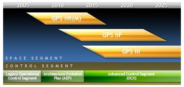
Moreover, in order to improve the anti-jamming and secure access of the military GPS signals, a new military signal (M-code) will be transmitted in L1 and L2 frequencies. Regarding the Ground Segment, the new Operational Control Segment (OCX) will replace the current GPS Operational Control System placed at Schriever Air Force Base.[3][4] The OCX will maintain backwards compatibility with the Block IIR and IIR-M constellation satellites, providing command and control of the new GPS IIF and GPS III families of satellites, and enabling new modernized civil signal capabilities.
In addition to the specific new features noted above, GPS modernization is introducing modern technologies throughout the space and control segments that will enhance overall performance. For example, legacy computers and communications systems are being replaced with a network-centric architecture, allowing more frequent and precise satellite commands that will improve accuracy for everyone.
- Ending Selective Availability
The first step in GPS modernization took place in May 2000, when President Bill Clinton directed the Department of Defense to turn off the GPS Selective Availability (SA) feature. SA was an intentional degradation of civilian GPS accuracy, implemented on a global basis through the GPS satellites. During the 1990s, civil GPS readings could be incorrect by as much as a football field (100 meters). On the day SA was deactivated, civil GPS accuracy improved tenfold, benefiting civil and commercial users worldwide.
In 2007, the U.S. government announced plans to permanently eliminate SA by building the GPS III satellites without it.
- Program Schedule
The GPS modernization program involves a series of consecutive satellite acquisitions, including GPS IIR(M), GPS IIF, and GPS III. It also involves improvements to the GPS control segment, including the Architecture Evolution Plan (AEP) and the Advanced Control Segment (OCX). The schedule for the parallel space and control segment upgrades is shown in next figure (the information on the schedule is correct as of May 2011).


