If you wish to contribute or participate in the discussions about articles you are invited to contact the Editor
SBAS Interoperability
| EGNOS | |
|---|---|
| Title | SBAS Interoperability |
| Author(s) | GMV. |
| Level | Basic |
| Year of Publication | 2011 |
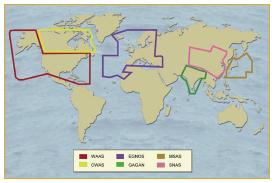
In the mid-1990s, three regions took up the gauntlet to develop SBAS systems: Europe, the US, and Japan.[1]
In the United States of America, the Federal Aviation Administration has taken the lead for developing its Wide Area Augmentation System or WAAS. The WAAS signal was made available for non-aviation users in 2000. It currently delivers accuracies of one meter horizontal and two meters vertical and supports aviation precision approach (APV-1) performance. An Initial Operational Capability (IOC) for aviation use started in July 2003 and its Full Operational Capability (FOC) is planned for the end of 2007.
Japan is developing an SBAS founded on its Multi-function Transport Satellite (MTSAT) called the MTSAT Satellite Augmentation System or MSAS. The first phase based on single geostationary satellite coverage is planned for 2005 while the second phase based on dual geostationary satellite coverage is planned for 2006. We expect MSAS to deliver a Non Precision Approach capability, and this could be enhanced to provide precision approach performances (e.g. APV-1).
Other regions, such as Japan, provide its own SBAS system, named MSAS (MTSAT-based satellite augmentation system).

