If you wish to contribute or participate in the discussions about articles you are invited to contact the Editor
GLONASS General Introduction
| GLONASS | |
|---|---|
| Title | GLONASS General Introduction |
| Author(s) | GMV |
| Level | Basic |
| Year of Publication | 2011 |
GLONASS is a space-based global navigation satellite system (GNSS) that provides reliable positioning, navigation, and timing services to users on a continuous worldwide basis freely available to all. GLONASS receivers compute their position in the GLONASS Reference System using satellite technology and based on triangulation principles. It is an alternative and complementary to other GNSS systems such as the United States' Global Positioning System (GPS), the Chinese COMPASS navigation system or the planned GALILEO positioning system of the European Union (EU).
Introduction
The first Soviet navigation spacecraft “Cyclone” was launched into orbit in 1967.[1] This was the beginning of the first Soviet low orbit navigation system, called “Cicada”. It was composed of four satellites placed in circular orbits at an altitude of 1000 km and an inclination of 83 degrees and could provide positioning data within the limits of several hundred meters. Nevertheless the requirements to space navigation were constantly increasing and low-orbit systems could not comply with the requirements of all potential users.
Flight tests of high altitude (20000 km) satellite navigation system, called GLONASS were started in 12 October 1982 with the launch of the Kosmos-1413, Kosmos-1414, and Kosmos-1415[1]. After the disolution of the Soviet Union in 1991, the system was continued by the Russian Federation which formaly declared the system operational in 1993 [2] and brought to its optimal status of 24 operational satellites in 1995.
Following completion, the system fell into disrepair with the collapse of the Russian economy and the reduction in funding for space industry [3]. In the early 2000s, under Vladimir Putin's presidency, the restoration of the system was made a top government priority and funding was substantially increased. In May 2007 Russian President Vladimir Putin signed a decree on the GLONASS navigation system to provide the service free for customers: "Access to civilian navigation signals of global navigation satellite system GLONASS is provided to Russian and foreign consumers free of charge and without limitations".[2]
GLONASS Signal Structure
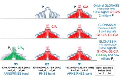
Each GLONASS system Space Vehicle (SV) "GLONASS" and "GLONASS-M" transmits navigational radiosignals on fundamental frequencies in two frequency sub-bands (L1 ~ 1,6 GHz, L2 ~ 1,25 GHz).[4]
It is important to remark that GLONASS relies on the Frequency Division Multiple Access (FDMA) technique in contrast to CDMA employed by all the other GNSS systems such GPS or GALILEO. Each satellite transmits navigation signals on its own carrier frequency, so that two GLONASS satellites may transmit navigation signals on the same carrier frequency if they are located in antipodal slots of a single orbital plane.
The frequency of transmission of each GLONASS satellite can be derived from the channel number k:[5] by applying the following expressions[4]
- [math]\displaystyle{ f_{k1} =f_{01} + k\Delta f_1 }[/math], where [math]\displaystyle{ f_{01} =1602 MHz }[/math] and [math]\displaystyle{ \Delta f_1=562.5 KHz }[/math]
- [math]\displaystyle{ f_{k2} =f_{02} + k\Delta f_2 }[/math], where [math]\displaystyle{ f_{02} =1246 MHz }[/math] and [math]\displaystyle{ \Delta f_2=437.5 KHz }[/math]
The modernization of GLONASS will add a new third frequency G3 in the ARNS band for the GLONASS-K satellites. This signal will provide a third civil C/A2 and military P2 codes, being especially suitable for Safety-Of-Life applications.
GLONASS Reference Frame
Accurate and well-defined Time References and Coordinate Frames are essential in GNSS, where positions are computed from signal travel time measurements and provided as a set of coordinates (please refer to GNSS positioning).GLONASS time (GLONASST) is generated by the GLONASS Central Synchroniser (CS). Unlike GPS, the GLONASS time scale is adjusted for periodic leap Seconds and the difference between the UTC (Coordinated Universal Time) and GLONASST should not exceed 1 millisecond plus three hours.[4]
The GLONASS broadcast ephemeris describes a position of transmitting antenna phase center of given satellite in the PZ-90.02 Earth-Centered Earth-Fixed reference frame defined as follows [6]
- The ORIGIN is located at the center of the Earth's body.
- The Z-axis is directed to the Conventional Terrestrial Pole as recommended by the International Earth Rotation Service (IERS) .[7]
- The X-axis is directed to the point of intersection of the Earth's equatorial plane and the zero meridian established by the Bureau International de l'Heure (BIH).
- The Y-axis completes the coordinate system to the right-handed on.
GLONASS Services
Two services are available from GLONASS system:[8]
- SPS: The Standard Positioning Service (or Standard Accuracy Signal service) is an open service, free of charge for worldwide users. The navigation signal was initially provided only in the frequency band G1, but from 2004 on the new GLONASS-M transmits also a second civil signal in G2.
- PPS: The Precise Positioning Service (or High Accuracy Signal service) is restricted to military and authorized users. Two navigation signals are provided in the two frequency bands G1 and G2.
GLONASS Architecture
GLONASS is comprised of three segments: a GLONASS Space Segment (SS), a GLONASS Ground Segment (CS), and a GLONASS User Segment (U.S.).[4]
GLONASS Space Segment is composed of 24 satellites in three orbital planes whose ascending nodes are 120 degrees apart. Eight satellites are equally spaced in each plane with argument of latitude displacement of 45 degrees.[9] The satellites operate in circular orbits at an altitude of 19100-km, an inclination of 64.8 degrees and each satellite completes the orbit in approximately 11 hours 15 minutes. The spacing of the satellites allows providing continuous and global coverage of the terrestrial surface and the near-earth space. GLONASS Ground Segment includes the System Control Center and the network of the Command and Tracking Stations that are located throughout the territory of Russia. The control segment provides monitoring of GLONASS constellation status, correction to the orbital parameters and navigation data uploading. Finally, GLONASS User Segment consists in the user receivers which compute coordinates, velocity and time from the GLONASS navigation signals.
GLONASS Performances
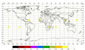
At the moment of this publication (April 2011) there are 27 GLONASS satellites in orbit although only 23 of them are operational. Availability performance (calculated as the percentage of time during which the condition PDOP ≤ 6 is valid at mask angles ≥ 5 deg.) obtained with the current constellation is shown in the right figure.
With regard to GLONASS accuracy, according Russian System of Differentional Correction and Monitoring's [9], as of 24 April 2011, GLONASS horizontal precision is in the order of 5-10 m whereas the vertical error is in the order of 10-20 meters.
| Station | GLONASS Error of navigation def. (p=0,95) | Mean number of NSV. | ||
|---|---|---|---|---|
| latitude (m) | longitude (m) | altitude (m) | ||
| Bellinsgauzen | 5.14 | 6.60 | 10.41 | 8 |
| Gelendzhik | 4.81 | 6.18 | 17.98 | 8 |
| Irkutsk | 8.86 | 6.59 | 16.79 | 9 |
| Kamchatka | 6.70 | 7.42 | 11.40 | 9 |
Analyzing the accuracy obtained with GPS in the same stations it can be derived that GLONASS is slightly less accurate than GPS. In the same way, the mean number of GLONASS satellites in view is lower than GPS.
| Station | GPS Error of navigation definitions (p=0,95) | Mean number of NSV | ||
|---|---|---|---|---|
| latitude (m) | longitude (m) | altitude (m) | ||
| Bellinsgauzen | 3.23 | 2.38 | 7.98 | 11 |
| Gelendzhik | 4.12 | 2.68 | 8.01 | 10 |
| Irkutsk | 4.10 | 2.87 | 7.04 | 10 |
| Kamchatka | 3.98 | 2.84 | 5.96 | 10 |
GLONASS Future and Evolutions
GLONASS modernization began with the launch of second generation of satellites, known as Glonass-M, in 2003. Currently, the number of satellites in the constellation is 27, 23 operational, one in commissioning phase and three in maintenance. [5] The following generation of satellites, GLONASS-k, has a service life of 10 years and includes, for the first time, code-division-multiple-access (CDMA) signals accompanying the legacy frequency-division-multiple-access signals. There will be two versions:
- GLONASS-K1 will transmit a CDMA signal located in the L3 band. The first GLONASS-K1 satellite was successfully launched on February 26 2011 [10] and the new L3 CDMA signal is already being tracking by several receiver companies.[11][12]
- GLONASS-K2 to be launched in 2013, will feature three additional CDMA signals near the original FDMA frequencies, one obfuscated signal located at 1242 MHz in the L2 band, as well as two signals at 1575.42 MHz in the L1 band.
A modernized GLONASS-K satellite, GLONASS-KM, for launch after 2015 [13] may also be transmitted on the GPS L5 frequency at 1179.45 MHz. Also being studied is an alternative to the present three-plane, equally spaced satellite constellation.
Notes
References
- ^ a b GLONASS History on Information-analytical centre
- ^ a b Announcement of Putin making GLONASS free for customers
- ^ GLONASS History on wikipedia
- ^ a b c d GLONASS Interface Control Document, Edition 5.1
- ^ a b GLONASS Constellation Status
- ^ GLONASS Coordinate System
- ^ Earth Rotation Service (IERS)
- ^ J. Sanz Subirana, JM. Juan Zornoza and M. Hernández-Pajares, Global Navigation Satellite Systems: Volume I: Fundamentals and Algorithms
- ^ a b Russian System of Differentional Correction and Monitoring
- ^ Russia’s First GLONASS-K In Orbit, CDMA Signals Coming, insidegnss
- ^ Septentrio’s AsteRx3 Receiver Tracks First GLONASS CDMA Signal on L3
- ^ First GLONASS CDMA Signal Tracked
- ^ GLONASS Update Delves into Constellation Details, GPSworld


