If you wish to contribute or participate in the discussions about articles you are invited to contact the Editor
Category:EGNOS Signal Structure
| This category uses the form xxx. |
|
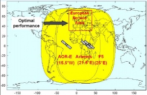
DescriptionThe EGNOS signal is broadcast by two Inmarsat-3 satellites – one positioned east of the Atlantic, and the other above Africa – and by ESA’s Artemis satellite, which is also above Africa. These three satellites’ orbits are in the equatorial plane, at three different longitudes, with each able to broadcast EGNOS services across the whole ECAC area.[1] Unlike the GPS and GLONASS satellites, these three space platforms carry no signal generators. They are fitted with a transponder which does nothing more than relay the signal processed on the ground and sent into space. EGNOS is fully interoperable with the GPS system, which is currently being modernized to take into account new civil signals on the L5 frequency band that GPS will be transmitting and future Galileo signals. EGNOS SIS Interface CharacteristicsThe EGNOS Signal In Space format is compliant with the ICAO SARPs for SBAS.[1] The following section provides an overview of the EGNOS SIS interface characteristics, related to carrier and modulation radio frequency. Message structure, protocol and content of the EGNOS message are detailed in the EGNOS Message Format definition.
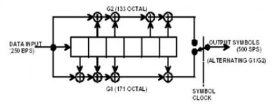
EGNOS SIS RF CharacteristicsThe EGNOS GEO satellites transmit right-hand circularly polarised (RHCP) signals in the L band at 1575.42 MHz (L1). The broadcast signal is a combination of a 1023-bit PRN navigation code of the GPS family and a 250 bits per second navigation data message carrying the corrections and integrity data elaborated by the EGNOS ground segment. This raw navigation message is ½ convolutional encoded with Forward Error Correcting (FEC) Code resulting in a 500 symbol/second EGNOS data stream. This data stream is added modulo-2 to a 1023-bit PRN code, which will then be biphase shift-keyed (BPSK) modulated onto the L1 carrier frequency at a rate of 1.023 Mega-chips/second (Mcps). [2] The EGNOS SIS is such that, at all unobstructed locations near ground level from which the satellite is observed at an elevation angle of 5 degrees or higher, the level of the received RF signal at the output of a 3dBi linearly polarised antenna is within the range of –161 dBW to –153 dBW for all antenna orientations orthogonal to the direction of propagation. Besides, spurious transmissions will be at least 40dB below unmodulated carrier power over all frequencies. It is intended that future geostationary satellites used for EGNOS replenishment will broadcast higher minimum signal power levels in order to improve the acquisition and tracking performance of the user receiver. The most relevant EGNOS signal characteristics are detailed hereafter:[2]
GPS/SBAS Signal GeneratorsA range of signal generators were developed in the GNSS Industry as a means to provide flexible platforms for the These products allow to select specific navigation satellite systems, to define influencing error sources, to choose signal frequency and modulations schemes as well as the RF Front end and filter characteristics. These generators are easy to integrate on user test environments and their purpose is to evaluate acquisition and tracking algorithms or receiver HW, to design multipath and interference mitigation strategies. Some of the most representative product manufacturers are Spirent[3] and Novatel.[4] Notes
References
|
||||||||||||||||||||||||||||
Pages in category "EGNOS Signal Structure"
This category contains only the following page.


