If you wish to contribute or participate in the discussions about articles you are invited to contact the Editor
IRNSS Signal Plan
| Fundamentals | |
|---|---|
| Title | IRNSS Signal Plan |
| Author(s) | J.A Ávila Rodríguez, University FAF Munich, Germany. |
| Level | Advanced |
| Year of Publication | 2011 |

In this article are described the signals corresponding to the Indian Regional Navigational Satellite System (IRNSS), which is a regional satellite navigation system owned by the Indian government. The system is being developed by Indian Space Research Organization (ISRO).
In April 2016, with the last launch of the constellation's satellite, IRNSS was renamed Navigation Indian Constellation (NAVIC) by India’s Prime Minister Narendra Modi.[1]
The messaging service signals from the Indian Regional Navigation Satellite System (IRNSS) are broadcast in L5 and S band frequencies. The carrier frequency and the bandwidth of transmission for the messaging service are:[2]
| Signal | Carrier Frequency | Bandwidth |
|---|---|---|
| L5 | 1176.45 MHz | 24 MHz (1164.45 -1188.45 MHz) |
| S | 2492.028 MHz | 16.5 MHz (2483.778 - 2500.278 MHz) |
| L1 | 1575,42 MHz | 24 MHz (1551,42 - 1599,42 MHz) |
In the following figures are shown the L5 and S bands in the spectrum of Radio Navigation Satellite Services.
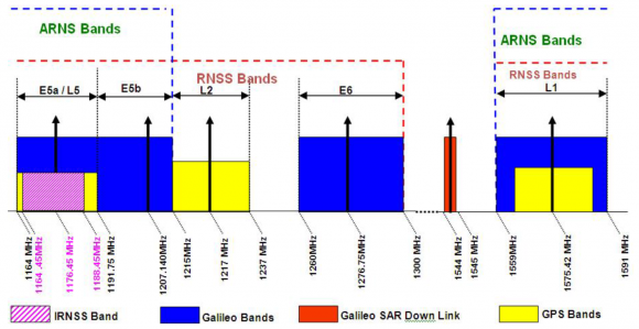
Figure 1: Spectrum for Radio Navigation Satellite Services in L Band.[2]

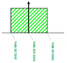
Figure 2: Spectrum for IRNSS Signal in S Band.[2]

Given the similarity with the Galileo signals in terms of services that IRNSS might be providing, the same convention as for Galileo was employed. That is A for the PRS and B and C for the Open Service data and pilot signals respectively.
Moreover, India also transmits similar signals for the S-band to those we have just described for the L5 band. The carrier frequency of S-band is at 2491.75 MHz. The modulation schemes and data rates are the same as for L5 (BPSK(1) and BOC(5,2)). In addition, India has started to transmit signals in L1 as it was announced during the second Meeting of the ICG in India, in 2007. Two L1 signals are also added on the last IRNSS satellites: one L1 MBOC and a BPSK(n) shifted from 18.414 MHz above L1. They are compatible with other L1, L5 and S GNSS Open signals. In addition, has introduced NeQuick-N model for Ionospheric delay modeling in L1-SPS signal, removing the need of having an additional SBAS channel only for Ionospheric corrections over Indian region for receiving the error correction values[3]
References
- ^ With IRNSS-1G launch, India completes and renames its navigation constellation
- ^ a b c IRNSS Signal-In-Space ICD v1.1
- ^ Update on NavIC Signal Monitoring Receiver and The Advantage of NavIC L1 SPS 2017, by Saumi S., Rohan S. Urdhwareshe, Saurabh Bhalla, Rakesh Kr. Bijarniya and Sagar Subudhi
Credits
The initial information presented in this NAVIPEDIA’s article was an extract of the PhD work performed by Dr. Jose Ángel Ávila Rodríguez in the FAF University of Munich as part of his Doctoral Thesis “On Generalized Signal Waveforms for Satellite Navigation” presented in June 2008, Munich (Germany)
This article has been updated by GMV considering the information stated in the latest IRNSS Signal Interface Specification.