If you wish to contribute or participate in the discussions about articles you are invited to contact the Editor
WAAS Space Segment
| WAAS | |
|---|---|
| Title | WAAS Space Segment |
| Edited by | GMV |
| Level | Basic |
| Year of Publication | 2011 |
The Wide Area Augmentation System (WAAS) is the United States Satellite Based Augmentation System. The programme, started in 1992, is being carried out by the Federal Aviation Agency (FAA)[1] and is specially developed for the civil aviation community.[2] The system, which was declared operational on July 2003,[3] currently supports thousands of aircraft instrument approaches in more than one thousand airports in USA and Canada.[4] WAAS service area includes CONUS, Alaska, Canada and Mexico.[5] The WAAS programme is continuously in evolution; two development phases have been already covered, a third is in progress, and there are plans to improve the capability of the system in parallel with the evolution of the SBAS standards towards a dual-frequency augmentation service.[6]
WAAS Space Segment
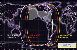
The WAAS Space Segment is composed by several geosynchronous communication satellites (GEO) in charge of broadcasting, over the WAAS service area, the WAAS augmentation message.
The WAAS system started with two satellites: Pacific Ocean Region (POR) and Atlantic Ocean Region-West (AOR-W), these satellites ceased WAAS transmissions on July 31, 2007. Before these satellites ceased their transmission, two more satellites, Galaxy15 and AnikF1R, were launched in 2005. After that, a new one added in March 2010, and it started transmitting a test signal whcih wasn't able for navigation but could be received and was reported with the identification number PRN 133 (NMEA#46. In November 2010, this signal was certified and declared available for navigation.:[7]. The GEO satellites which follow this one are currently operating and included in the following table: [8]
| Satellite Name & Details | NMEA / PRN | Location |
|---|---|---|
| Eutelsat 117 Wet B(SATMEX 9) | NMEA #44 / PRN #131 | 117°W |
| Anik F1R (CRE) | NMEA #51 / PRN #138 | 107.3°W |
| SES 15 |
NMEA #46 / PRN #133 | 129°W |
Notes
References
- ^ Navigation Services - History - Satellite Navigation, FAA.
- ^ Navigation Services - Wide Area Augmentation System (WAAS), FAA.
- ^ Wide Area Differential GPS (WADGPS), Stanford University
- ^ GNSS - GPS/WAAS Approaches, Federal Aviation Agency (FAA).
- ^ WAAS Service Expanded into Canada and Mexico, September 28, 2007, Federal Aviation Agency (FAA).
- ^ SatNav News, Vol. 33, March 2008, Federal Aviation Agency (FAA).
- ^ a b Wide Area Augmentation System in Wikipedia
- ^ WAAS Space segment information in GPS official web site

