If you wish to contribute or participate in the discussions about articles you are invited to contact the Editor
GPS Ground Segment
| GPS | |
|---|---|
| Title | GPS Ground Segment |
| Edited by | GMV |
| Level | Basic |
| Year of Publication | 2011 |
The GPS Ground Segment (also referred to as Control Segment or Operational Control System) is the responsible for the proper operation of the GPS system.
The GPS Control Segment consists of a global network of ground facilities that track the GPS satellites, monitor their transmissions, perform analysis, and send commands and data to the constellation[1].
Introduction
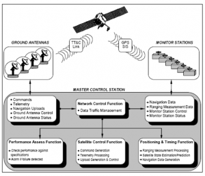
The Ground Segment, also referred to as Control Segment or Operational Control System, OCS, is the responsible for the proper operation of the GPS system. The main tasks performed by the CS are the following:
- Monitoring and control of satellite orbital parameters;
- Monitoring health and status of the satellite subsystems (solar arrays, battery power and the level of propellant used for maneuvers);
- Activation of spare satellites;
- Update of parameters in the navigation message (ephemeris, almanac and clock corrections);
- Resolving satellite anomalies;
- Controlling Selective Availability (SA) and Anti-Spoofing (A/S)
- Passive tracking of the satellites.
The Ground Segment is comprised of four major subsystems:[2]
- Master Control Station (MCS)
- Alternate Master Control Station
- Network of ground antennas (GAs),
- Network of globally-distributed monitor stations (MSs).
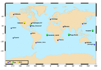
The current Operational Control Segment (OCS) includes a Master Control Station (MCS), an alternate Master Control Station, 11 command and control antennas (GA), and 16 monitoring sites (MS). The locations of these facilities are shown in the map below.
The Master Control Station
Located at Colorado Springs, the Master Control Station (MCS) is the central control node for the GPS satellite constellation. The MCS is responsible for all aspects of constellation command and control, to include:[2]
- Routine satellite bus and payload status monitoring.
- Satellite maintenance and anomaly resolution.
- Monitoring and management of Precise Positioning Service (PPS) Signal-In-Space (SIS) performance in support of all performance standards.
- Navigation message data upload operations as required to sustain performance in accordance with accuracy and integrity performance standards.
- Detecting and responding to PPS SIS failures.
The Monitor Stations
They are distributed around the world and equipped with atomic clocks standards and GPS receivers to continuously collect GPS data for all the satellites in view from their locations. The collected data is sent to the Master Control Station where it is processed to estimate satellite orbits (ephemerides) and clock errors, among other parameters, and to generate the Navigation Message.
Prior to the modernization program, the Monitor Stations network comprised five sites located in[3]:
- Hawaii,
- Colorado Springs (Colorado, US),
- Ascension Island (South Atlantic),
- Diego Garcia (Indian Ocean),
- Kwajalein (North Pacific).
In order to increase performance and accuracy, new stations were incorporated into the ground segment providing greater visibility of the constellation: Cape Canaveral (Florida, US) was incorporated in 2001 and six new stations in 2005:[4]
- Adelaide (Australia),
- Buenos Aires (Argentina),
- Hermitage (UK),
- Manama (Bahrain),
- Quito (Ecuador)
- Washington DC (USA).
Five more stations were added afterwards in 2006:
- Fairbanks (Alaska),
- Osan (South Korea),
- Papeete (Tahiti),
- Pretoria (South Africa)
- Wellington (New Zealand).
With this configuration, each satellite is seen from at least three monitor stations,[3] which allows computing more precise orbits and ephemeris data, therefore improving system accuracy.
The Ground Antennas
The Ground Antennas uplink data to the satellites via S-band radio signals. These data includes ephemerides and clock correction information transmitted within the Navigation Message, as well as command telemetry from the MCS.
This information can be uploaded to each satellite three times per day, i.e., every 8 hours; nevertheless, it is usually updated just once a day.
The ground antennas are co-located in four of the Monitor stations:
- Ascension Island
- Cape Canaveral
- Diego Garcia
- Kwajalein
Notes
References
- ^ GPS Ground Segment information in GPS official website
- ^ a b GPS Standard Positioning Service (SPS) Performance Standard, 4th Edition, September 2008
- ^ a b J. Sanz Subirana, JM. Juan Zornoza and M. Hernández-Pajares, Global Navigation Satellite Systems: Volume I: Fundamentals and Algorithms
- ^ GPS Modernization Fact Sheet


