If you wish to contribute or participate in the discussions about articles you are invited to contact the Editor
DGNSS Systems
| Fundamentals | |
|---|---|
| Title | DGNSS Systems |
| Edited by | GMV |
| Level | Basic |
| Year of Publication | 2011 |
Among the different GNSS Augmentation systems, the DGNSS system were the first ones to be developed and now are widely used by navigation users. Nowadays, almost all commercial GPS units, even hand-held units, offer DGPS data inputs. To some degree, a form of DGPS is now a natural part of most GPS operations.[1]
DGNSS Systems
There are many operational systems in use throughout the world; according to the US Coast Guard, 47 countries operate systems similar to the US NDGPS (Nationwide Differential Global Positioning System).[1] Next, there are some significant examples of DGNSS systems by country/countries:
United States
The first DGNSS system was developed by the United States Coast Guard, called firstly DGPS and that has evolved to the US NDGPS (Nationwide Differential Global Positioning System).[1]
The United States Department of Transportation, in conjunction with the Federal Highway Administration, the Federal Railroad Administration and the U.S. National Geodetic Survey appointed the U.S. Coast Guard as the maintaining agency for the U.S. Nationwide DGPS network. The system is an expansion of the previous Maritime Differential GPS (DGPS) which the Coast Guard began in the late 1980s and completed in March 1999. DGPS only covered coastal waters, the Great Lakes, and the Mississippi River inland waterways, while NDGPS expands this to include complete coverage of the continental United States.[2] The centralized Command and Control unit is USCG Navigation Center, based in Alexandria, VA.[3] The USCG has carried over its NDGPS duties after the transition from the Department of Transportation to the U.S. Department of Homeland Security. There are 82 currently broadcasting NDGPS sites in the US network.
Beginning January 15, 2016, federal agencies responsible for the system plan to close and decommission 62 of the 84 operational NDGPS sites.[4]
Canada
The Canadian system is similar to the US system and is primarily for maritime usage covering the Atlantic and Pacific coast as well as the Great Lakes and Saint Lawrence Seaway. It has been developed by the Canadian Coast Guard and it also overlaps US DGPS coverage of contiguous waters.[1]
Australia
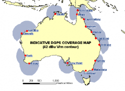
Australia runs two DGPS systems: one is mainly for marine navigation, run by Australian Maritime Safety Authority, broadcasting its signal on the longwave band; the other is used for land surveys and land navigation, and has corrections broadcast on the Commercial FM radio band.[1]
European DGPS Network
The European DGPS network has been mainly developed by the Finnish and Swedish maritime administrations in order to improve safety in the archipelago between the two countries.[1]
In the UK and Ireland, the system was implemented as a maritime navigational to fill the gap left by the demise of the Decca Navigator System in 2000[5]. With a network of 12 transmitters sited around the coastline and three control stations, it was set up in 1998 by the countries' respective General Lighthouse Authorities (GLA) - Trinity House covering England, Wales and the Channel Islands, the Northern Lighthouse Board covering Scotland and the Isle of Man and the Commissioners of Irish Lights covering the whole of Ireland. Transmitting on the 300 kHz band, the system underwent testing and two additional transmitters were added before the system was declared operational in 2002.
Other DGNSS Systems
There are other DGNSS techniques used by high-precision navigation/surveying applications, based on the use of carrier phase measurements. These are the cases of the Real Time Kinematics (RTK) and the Wide Area RTK (WARTK).
Credits
Edited by GMV. Most of the information in this article includes text taken from Wikipedia with minor adaptation,[1] provided under Creative Commons Attribution-ShareAlike License.
Notes
References
- ^ a b c d e f g Differential GPS, wikipedia
- ^ 2005 FEDERAL RADIONAVIGATION PLAN, USA Department of Defense, Department of Homeland Security, and Department of Transportation
- ^ United States Coast Guard Navigation Center, Alexandria, VA; Standard Operating Procedures (2002)
- ^ Federal Agencies Move to Close Most NDGPS Sites
- ^ Decca Navigator in Wikipedia

