If you wish to contribute or participate in the discussions about articles you are invited to contact the Editor
Step By Step Navigation
| Applications | |
|---|---|
| Title | Step By Step Navigation |
| Author(s) | Henrique Köhler |
| Level | Basic |
| Year of Publication | 2013 |
Navigation can be considered as one of the most common applications of GNSS. Typically Navigation Systems provide indications to help users reach their destination from their current position. These indications appear in the navigation systems and navigation software applications in different forms and formats. The most used types of indications are:
- Turn by Turn Indications;
- Highlights on Maps;
- Pin-Pointing on Maps;
Although traditional types of indications seem to meet the user needs, there are ongoing studies to understand the weak points of each methodology in order to offer new types of indications that could facilitate the process of finding a given location. Two examples of those studies are the Direction Codes and Location Codes.
Turn by Turn Indications
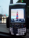
This method is used to guide users along well defined paths like roads or streets and it is based on providing indications about the need of changing direction in order to reach the destination. The indications are computed in the beginning and then they are updated as the user comes to intermediate points. Please note that the application typically re-computes the indications in case the user wanders away from the recommended path. These types of indications are typically conveyed by recorded voice or using graphical indications (or both), as they are mainly used by car drivers that need to focus their attention to the road. Turn by turn indication can also be useful in Indoor Navigation in complex buildings as shopping malls, hospitals, airports, etc. … In general these kinds of indications are present in all applications characterized as Road Navigation or Pedestrian Navigation.
Highlights on Maps
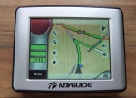
Some applications show a map covering the interest area and highlight the streets and/ or roads that need to be crossed in order to reach the target destination. This is used either to give an overview of the computed route or to allow users to easily understand which street/ road they should follow.
Normally this method is used as a complement of the Turn by Turn Indications since it is very helpful in ambiguous changes of direction. Road Navigation and Pedestrian Navigation usually include this feature.
Pinpointing on Maps
In applications that offer the possibility of searching locations (addresses, buildings, cities, countries, etc. …) it is common to show them on maps using pinpoints. This is very useful when the user has an idea of the surrounding geography since it gives an overall indication about how to reach the target location. Furthermore this is also very used to disambiguate searches that return several results.
In addition, this strategy is also used to let the users define locations of interest. An example of this use is the definition of Points Of Interest (POI) normally provided by all Road Navigation and Pedestrian Navigation applications.
Direction Codes
Sometimes it can be convenient to quantify a direction.
For example, soldiers, pilots and boy scouts use imaginary clocks at least to minimize right/left or east/west confusions. This quantification tool also allows to easily calculate turn angles: if the compass indicates or speaks that the actual drive direction is “7 o’clock” and the driver knows that the target is at 5 o’clock from the next crossing, so he can calculate that he has to turn 2 hours to “earlier”.
Imaginary clocks could also be helpful on turn by turn indications but there are north or view direction based clocks and for that there was no convention or standard.
According to studies which have started in Munich, the following convention for egocentrical clocks is proposed:
- Munich clock: m12 = from body to north (m3 = sunrise, m9 = sunset etc.)
- F-clock: f12 = your front direction (f3 = right hand, f6 = behind etc.)
- Emergency clock: e12 = basic direction on emergency situations (e. g. from accident location to the mountain)
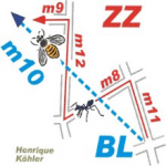
According to this and to the examples in the figure on the right, additional conventions are proposed:
- ZigZag navigation (ZZ):
- chained m-clocks: m11 m8 m12 m9
- chained f-clocks: f11? f9 f4 f9
- Bee line navigation (BL): m10
In many cases, the BL navigation will be the best one. If the user has to walk “too later” (e.g. m11 instead of m10), on the next point of decision he will automatically turn counterclockwise / to earlier / to left.
Location Codes
During a study to reform of the enigmatic house numbering in Japan, a global market gap was discovered: there are no simple answers to the simple question “where”. Let’s see an example obtained with such orientation tools when applied to ESAC address:
- Camino bajo del Castillo, s/n ?
- Urbanizacion Villafranca del Castillo ?
- Villanueva de la Cañada ?
- E-28692 ?
- Madrid
- 40.4438 N 3.9529 W ?
- pointing “here” on a map ?
- extensive routing instructions ?
The main weak points of such tools are:
- average people don’t dominate geocoordinates, also because the reference point is far away.
- post codes only make sense for the post administrations.
- half of the humanity isn’t able to read maps, mainly if the target is behind of the reader. Everyone is forced to decode image information into a chain of right/left commands. A single right/left confusion – a very common occurrence - breaks this chain.
This gap complicates the man-man, machine-man and man-machine communication. Logical location codes are proposed which base on imaginary clocks, a method used by soldiers, boy scouts, pilots, the blind etc. for more than 100 years. The proposal is explained basing on the same target: ESAC StatusQuo Madrid m9:30 r213.
| Code element | Description | Details |
|---|---|---|
| Status Quo Madrid | Prefix of a location code | Madrid area |
| m12 | basic horizon hour | Direction from Puerta del Sol to north.
This method divides the city like a cake into 12 sectors. |
| m9 | horizon hour | Direction from Puerta del Sol to sunset |
| :30 | horizon minutes | 30 x 100 meters “later” than the horizon hour, in this case m9 |
| r213 | Radius | 213 x 100 meters from the Puerta del Sol |
This method looks like the military ro-theta navigation. The fundamental difference is the division of the horizon into 12 instead of 360 main directions and the fundamental innovation is the division of the hour sectors into distance-minutes instead of angle-minutes.
The same method generates the following codes for the other named locations:
- Castle of Villafranca StatusQuo(c) Madrid m9:30 r215
- Villanueva de la Cañada m9:30 r255
- Villafranca del Castillo m9:60 r210
Just comparing “time” and radius, it’s possible to deduce the following information:
- the castle is situated r215 - r213=200 meters from ESAC in direction outwards. On sector m9, outwards means also “to sunset”.
- the town Villafranca del Castillo is situated :60 - :30 = 3 km “later” than ESAC. On sector m9, “to later” means also “to north”.
- ESAC is situated 255-213= 4,2 km closer to Madrid than the town Villanueva del Cañada
Such urban codes can replace post codes and harmonize with codes for crossings, stations, stop points, bridges etc. The method can also be used indoor to address rooms, WC, emergency stairs etc., and globally to address towns, road exits, islands, volcanos etc.
Location codes have the following characteristics:
- have a local georeference
- are a metrical alternative to lan/lon
- can be converted from lat/lon
- make smarter and facilitate the communication
- sharpens the orientation sense
- helps to reduce signage and accidents
- are also proper for illiterate people
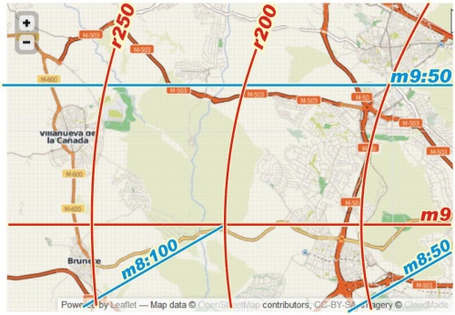
- harmonize with a clock based search grid on maps.
Such grids have no bound limitations, are a better interface to the reality, are zoomable without limitations, allow interpolation and allow an addressing outside of the map. The figure shows such a grid for the example ESAC. The grid contains quads which are similar to the conventional ones. Their bended sides let immediately detect the direction of the pole, even if the pole would be outside of the map.
Everyone who can read a clock - 6 billion people! - would have an alternative to right/left and lat/lon and would be able to navigate indoor, urban and on the globe as elegantly as in Rio de Janeiro around the Christ statue: inward or outward and clockwise or counterclockwise. Concerning the man-machine communication, the consumer will have a quantified alternative to express “where”, e. g. to ask search machines to list all hotels within r220 and r280 and between sector quads m8:100 and m9:70.
A standardisation of Location Codes and other natural tools is currently under consideration[1].


