If you wish to contribute or participate in the discussions about articles you are invited to contact the Editor
SNAS
| Fundamentals | |
|---|---|
| Title | SNAS |
| Author(s) | GMV |
| Level | Basic |
| Year of Publication | 2011 |
SBAS systems are spreading out all over the world. More and more, it is believed that upon dual-frequency SBAS service provision, a seamless navigation will be possible from and to any two locations in the world.
SBAS in the World
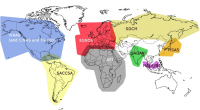
From all the SBAS systems in the world, three are already operational (WAAS, MSAS, EGNOS), three are under implementation (GAGAN, SDCM, SNAS) while others are under feasibility studies, for instance SACCSA.
SNAS
The People's Republic of China is developing its own SBAS, called Satellite Navigation Augmentation System (SNAS). The company Novatel was awarded with a contract for the provision of 12 receivers for the phase 2 of the development in 2002.[1] These stations would complement the 11 ones already installed around Beijing for the phase 1. There is little public information available on this development.
Notes

