If you wish to contribute or participate in the discussions about articles you are invited to contact the Editor
GLONASS Navigation Message
| Fundamentals | |
|---|---|
| Title | GLONASS Navigation Message |
| Author(s) | J. Sanz Subirana, JM. Juan Zornoza and M. Hernandez-Pajares, University of Catalunia, Spain. |
| Level | Basic |
| Year of Publication | 2011 |
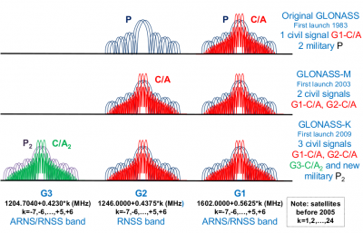
GLONASS satellites transmit right-hand circularly polarised signals centred on two radio-frequencies in L band, referred here to Link 1 (G1) and Link 2 (G2)[footnotes 1].
Two services are available from GLONASS system:
- SPS: The Standard Positioning Service (or Standard Accuracy Signal service) is an open service, free of charge for worldwide users. The navigation signal was initially provided only in the frequency band G1, but from 2004 on the new GLONASS-M transmits also a second civil signal in G2.
- PPS: The Precise Positioning Service (or High Accuracy Signal service) is re- stricted2 to military and authorised users. Two navigation signals are provided in the two frequency bands G1 and G2.
In contrast to GPS satellites that share the same frequencies, each GLONASS satellite is allocated a particular frequency within the band. This frequency determines the frequency channel number of the satellite3, and allow user receivers to identify the satellites. The actual frequency of transmission can be derived from the channel number k by applying the following expressions:
[math]\displaystyle{
\begin{array}{lcl}
Frequency \, band \ G1: f1(k) = 1602+k∗ \fraq{9}{16} = (2848+k)∗9/16MHz \\
Frequency \, band \ G2: f2(k) = 1246+k∗ \fraq{7}{16} = (2848+k)∗7/16MHz
\end{array}
 }[/math]
The frequency numbers k were originally envisaged to provide 24 channels, with k = 1,...,24, but according to guidelines of the International Electric Communication Union (MSE), all GLONASS satellites launched after 2005 will use k = −7, . . . , 6. This change was introduced to avoid interference problems with radio astronomy frequency bands and satellite communication services. The reduction from 24 to 12 channels is compensated at setting up, because two satellites in the same orbit transmit in exactly the same frequency but occupying antipodal locations. In this way, they will never be simultaneously in view from any user on the earth surface (nevertheless, space receivers will need to implement discriminating functions to distinguish the satellites).
In this way, two ranging codes, the coarse acquisition C/A (open civil code) and the precise P (military), are modulated into these frequencies together with a navigation message D, using the BPSK method. The C/A and P codes have 1ms and 1sec of period, and chip-widths of 586.7 and 58.67 meters, respectively, being about two times noisier than the GPS ones (see table 1).
As in GPS, the C/A code was initially modulated only on G1, while the military code P is modulated in both carrier frequencies, G1 and G2; however, the new GLONASS-M satellites (from 2004) also transmit the C/A signal in the G2 frequency band. On the other hand, and unlike the GPS, in GLONASS the PRN sequences of such codes are common for all satellites, because the receiver identifies the satellite by its frequency. The use of different frequencies for the satellites (FDMA) makes the GLONASS signals more robust against interference, and on the other hand, the short code lengths helps signal acquisition.
Notes
- ^ We use G1 and G2 instead of L1 and L2 to better differentiate from GPS. Nevertheless, the ICD uses L1 and L2: See this document

