If you wish to contribute or participate in the discussions about articles you are invited to contact the Editor
GLONASS Ground Segment
| GLONASS | |
|---|---|
| Title | GLONASS Ground Segment |
| Author(s) | GMV |
| Level | Basic |
| Year of Publication | 2011 |
The GLONASS Ground Segment (also referred to as Control Segment or Operational Control System) is the responsible for the proper operation of the GLONASS system. Like in GPS, the GLONASS Control Segment monitors the status of satellites, determines the ephemerids and satellite clock offsets and, twice a day, uploads the navigation data to the satellites.[1]
Introduction
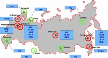
The GLONASS ground segment consists of:[2]
- A System Control Centre located at Krasnoznamensk.
- A network of five Telemetry, Tracking and Command centers (TT&C):
- Schelkovo
- Komsomoisk
- St-Peteburg
- Ussuriysk
- Yenisseisk
- The Central Clock situated in Schelkovo (near Moscow).
- Three Upload Stations:
- Yenisseisk
- Komsomoisk
- Schelkovo
- Two Laser Ranging Stations (SLR):
- Schelkovo
- Komsomoisk
- A network of four Monitoring and Measuring Stations:
- Schelkovo
- Krasnoznamensk
- Yenisseisk
- Komsomolsk
- Six additional Monitoring and Measuring Stations are to start operating on the territory of the Russian Federation and the Commonwealth of Independent States in the near future:
- Yakutsk
- Ulan-Ude
- Nurek
- Vorkuta
- Murmansk
- Zelenchuk
System Control Centre (SCC)
The System Control Center (SCC) is responsible for satellite constellation control and management of GLONASS satellites. It provides the telemetry, telecommand and control function for the whole GLONASS satellite constellation. The SCC coordinates all functions and operations at the system level. It processes the information from the Command and Tracking stations to determine satellite clock and orbit states, and updates the navigation message for each satellite.
Command and Tracking Stations
The Command and Tracking Stations are composed by a main network of five Telemetry, Tracking and Control (TT&C) stations distributed throughout the Russian territory. The CTSs track the GLONASS satellites in view and accumulate ranging data and telemetry from the satellites signals. The information from CTSs is processed at the SCC to determine satellite clock and orbit states and to update the navigation message of each satellite. This updated information is transmitted to the satellites via the Upload Stations, which are also used for the transmission of control information.
Laser Ranging Stations
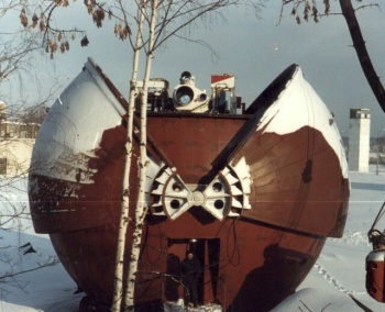
The high precision of laser ranging allows use of SLR as a single source of calibration data for GLONASS ephemeris determination, providing solution of following problems:[3]
- Estimation of accuracy, and calibration of radio-frequency means for GLONASS orbit measurements.
- Providing SLR stations with geodetic-class RF navigation receivers connected to hydrogen maser frequency standards allows monitoring of on-board clocks and use of the data for operational control of GLONASS time and ephemeris data.
- SLR station coordinates are used as geodetic base for the GLONASS reference frame.
- SLR data are used to provide declared values of ephemeris precision.
Central Synchronizer
The synchronization of all the processes in the GLONASS system is very important for its proper operability. The Central Synchronizer is a high-precise hydrogen atomic clock which forms the GLONASS system time scale. The onboard time scales (on a basis of satellite Cesium atomic clocks) of all the GLONASS satellites are synchronized with the State Etalon UTC (CIS) in Mendeleevo, Moscow region, through the GLONASS System Time scale.
Notes
References
- ^ J. Sanz Subirana, JM. Juan Zornoza and M. Hernández-Pajares, Global Navigation Satellite Systems: Volume I: Fundamentals and Algorithms
- ^ Current and planned global and regional navigation satellite systems and satellite-based augmentation systems
- ^ Russian Laser Tracking Network


