If you wish to contribute or participate in the discussions about articles you are invited to contact the Editor
GPS Space Segment
| GPS | |
|---|---|
| Title | GPS Space Segment |
| Author(s) | GMV |
| Level | Basic |
| Year of Publication | 2011 |
The main functions of the Space Segment are to transmit radio-navigation signals, and to store and retransmit the navigation message sent by the Control Segment. These transmissions are controlled by highly stable atomic clocks on board the satellites. [1]
Two main aspects define the space segment: One is the satellite constellations with enough satellites to ensure that the users will have, at least, 4 simultaneous satellites in view from any point at the earth surface at any time. The other aspect is the features of the satellites that occupy each orbital slot.
GPS Satellite Constellation
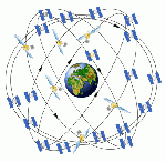
The nominal GPS satellite constellation consists of 24 space vehicles (SVs) distributed in six orbital planes with an inclination of 55 degrees in relation to the equator.
Orbits are nearly circular, with eccentricity less than 0.02, a semi-major axis of 26 560 km, i.e. an altitude of 20 200 km. Orbits in this height are referred to as MEO – medium earth orbit. The satellites orbit the Earth with a speed of 3.9 km per second and have a nominal period of 12 h sidereal time (11 h 58m 2 s), repeating the geometry each sidereal day. GPS SVs are arranged on 6 planes, each of them containing at least 4 slots. There is a spare satellite slot in each orbital plane, being the system capable of supporting a constellation of up to 30 satellites on orbit. The present configuration allows users to have a simultaneous observation of at least 4 satellites in view worldwide, with an elevation masking angle of 15 deg.[1]
In order to reduce or eliminate the times when there are only 4 or 5 GPS satellites in view above a 15 deg elevation mask, the US Air Force announced, in January 2010, a new expanded 24+3 GPS constellation plan or Expandable 24.[2][3] The GPS nominal constellation has traditionally consisted of 24 SVs. However, since the system supports up to 30 operational satellites, there are several redundant pairs. This change on the constellation will take up to 24 months to be fully implemented and it will increase the number of GPS satellites in view and geometry, potentially increasing accuracy of GPS receivers.[4][5]
GPS Satellite Description
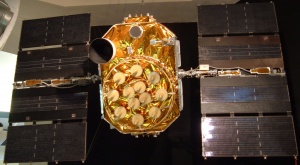
The design of GPS satellites has evolved with time. Each generation of satellites with similar characteristics is called a block. A brief description of the different GPS blocks follows:[1]
- Block I, Navigation Development Satellites: Eleven satellites of this kind were launched between 1978 and 1985.[6] The Selective Availability (S/A) was not implemented. They weighed about 845Kg and had a planned average life of 4.5 years, although some of them lasted up to 10. They were capable of giving positioning service for 3 or 4 days without any contact with the control centre.
- Block II and IIA, Operational Satellites: They consist of 28 satellites in total that were launched from 1989 on and many are still operating.[7] They weigh about 1 500 Kg and have a planned average life of 7.5 years. Since 1990, an improved version was used, Block IIA (advanced), with capability of mutual communication. They are able to supply positioning service for 180 days with no contact with the control segment. However, under normal operating mode, they communicate daily.
- Block IIR, Replacement Operational Satellites:[7] From 1997, these satellites are being used as spares for Block II. Block IIR is formed by a set of 20 satellites, although it could be increased by 6 more. They weigh about 2 000Kg and have a planned average lifespan of 10 years. These satellites have the capability to autonomously determine their orbits and generate their own navigation message. They are able to measure distances between them and transmit observations to other satellites or to the control segment. A satellite of this category, completely developed, must be capable of operating about half a year without any support from Control Segment and no degradation in ephemeris accuracy. It is expected that some of them could be equipped with Hydrogen masers.
- Block IIR-M, Modernized Satellites: They include a new military signal and the more robust civil signal L2C. There will be eight satellites in the Block IIR-M series. The first Block IIR-M satellite was launched on September 26, 2005 [7].
- Block IIF, Follow-on Operational Satellites: The first satellite (SVN62) was launched on May 28th 2010 [7][8]. These satellites will include the third civil signal on the L5 band. Their theoretical average life is about 15 years, and they will have inertial navigation systems.
- Block III: The new generation of GPS satellites will introduce significant enhancements in navigation capabilities, by improving interoperability and jam resistance. They will provide the fourth civil signal on L1 band (L1C). The first launch is expected as of 2016.
Finally, the following table gathers the main characteristics of a GPS Satellite:[9]
| Block II/IIA | Block IIR | Blork IIR-M | Block IIF | |
|---|---|---|---|---|
| Primary Contractors | Rockwell International (Boeing North American) | Lockheed Martin | Lockheed Martin | Boeing North American |
| Solar Power Plant | 800 watts | 800 watts | 800 watts | 2450 watts |
| Weight | 1,816 kg | 2,217 kg | 2,217 kg | 1,705 kg |
| Height | 3.4 meters | 1.7 meters | 1.7 meters | 2.4 meters |
| Width | 5.3 meters | 11.4 meters | 11.4 meters | 35.5 meters |
| Design Life | 7.5 years | 10 years | 10 years | 12 years |
Notes
References
- ^ a b c J. Sanz Subirana, JM. Juan Zornoza and M. Hernández-Pajares, Global Navigation Satellite Systems: Volume I: Fundamentals and Algorithms
- ^ Expandable 24 Announcement
- ^ New 24+3 GPS Configuration Will Increase Accuracy, GPSworld
- ^ GPS Program Update to CGSIC 201, LtCol Stephen Steine
- ^ The Best and Final Look at the GPS 24+3 Configuration, GPSworld
- ^ Block I Satellite Information
- ^ a b c d Block II Satellite Information
- ^ GPS Constellation Status
- ^ Global Positioning System Fact sheets


