If you wish to contribute or participate in the discussions about articles you are invited to contact the Editor
WAAS Performances
| WAAS | |
|---|---|
| Title | WAAS Performances |
| Author(s) | GMV. |
| Level | Basic |
| Year of Publication | 2011 |
The Wide Area Augmentation System (WAAS) is the United States Satellite Based Augmentation System. The programme, started in 1992, is being carried out by the Federal Aviation Agency (FAA)[1] and is specially developed for the civil aviation community.[2] The system, which was declared operational in late 2003,[3] currently supports thousands of aircraft instrument approaches in more than one thousand airports in USA and Canada.[4] WAAS service area includes CONUS, Alaska, Canada and Mexico.[5] The WAAS programme is continuously in evolution; two development phases have been already covered, a third is in progress, and there are plans to improve the capability of the system in parallel with the evolution of the SBAS standards towards a dual-frequency augmentation service.[6]
WAAS Performances
Performances are usually described in terms of accuracy, integrity, availability and continuity. The WAAS specification Performance Requirements[7] are different depending on the phase of the flight: en route through 1) Non-precision approach (NPA) and 2) Precision Approach.
The WAAS Performance Requirements as specified in FAA Specification for the Wide Area Augmentation System(WAAS) document are the following;
- WAAS Performance Requirements for Non-Precision Approach
| Performance Requirement | Total System | Navigation System | WAAS Signal-in-Space | Airborne |
|---|---|---|---|---|
| Availability | 0.999 | 0.999 | 0.999 | Not Specified (N/S) |
| Accuracy 95% Horizontal Position 99.999% Horizontal Position 95% Vertical Position 95% Pseudorange |
N/S N/S N/A N/A |
100 m 500 m N/A N/S |
N/S N/S N/A N/S |
N/S N/S N/A 1.2 m |
| Integrity Integrity Risk Time-to-Alarm |
N/S 10 s |
N/S 10 s |
10e-7/hour 8 s |
N/S 2 s |
| Continuity Continuity of Navigation Continuity of Fault Detection |
1 - 10e-5/hour 1 - (2x10e-5)/hour |
1 - 10e-5/hour 1 - (2x10e-5)/hour |
1 - 10e-8hour 1 - 10e-5/hour |
1 - 10e-5/hour 1 - 10e-5/hour |
- WAAS Performance Requirements for Precision Approach
| Performance Requirement | Total System | Navigation System | WAAS Signal-in-Space | Airborne |
|---|---|---|---|---|
| Availability | Not Specified (N/S) | N/S | 0.999 | N/S |
| Accuracy 95% Horizontal Position 95% Vertical Position 95% Pseudorange |
33.5 m 9.8 m N/A |
7.6 m 7.6 m N/S |
N/S N/S N/S |
N/S N/S 1.2 m |
| Integrity Integrity Risk Time-to-Alarm |
N/S N/S |
N/S N/S |
10e-7/approach 5.2 s |
N/S N/S |
| Continuity of Function Continuity of Navigation Continuity of Fault Detection |
1 - 10e-4/approach N/S N/S |
1 - 10e-4/approach N/S N/S |
1 - (5.5x10e-5)/approach N/S N/S |
1 - (4.5x10e-5)/approach N/S N/S |
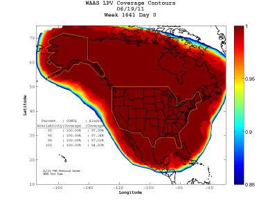
On July 10, 2003, the WAAS system was certified for for safety-of-life aviation, covering 95% of the United States, and portions of Alaska [8]. At present, WAAS supports en-route, terminal and approach operations down to a full LPV-200 (CAT-I like Approach Capability) for the CONUS, Mexico and Canada. Typical performances provided by WAAS System when considering operating in LPV (Horizontal Alarm Limit = 40 m , Vertical Alarm Limit =50 m) are shown in next figure:[9]
Notes
References
- ^ Navigation Services - History - Satellite Navigation, FAA.
- ^ Navigation Services - Wide Area Augmentation System (WAAS), FAA.
- ^ Wide Area Differential GPS (WADGPS), Stanford University
- ^ GNSS - GPS/WAAS Approaches, Federal Aviation Agency (FAA).
- ^ WAAS Service Expanded into Canada and Mexico, September 28, 2007, Federal Aviation Agency (FAA).
- ^ SatNav News, Vol. 33, March 2008, Federal Aviation Agency (FAA).
- ^ FAA.Specification for the Wide Area Augmentation System(WAAS). FAA-E- 2892b. August 13, 2001.
- ^ Wide Area Augmentation System
- ^ FAA Monitoring WAAS Performances in Real-Time

