If you wish to contribute or participate in the discussions about articles you are invited to contact the Editor
Regional Datums and Map Projections: Difference between revisions
Carlos.Lopez (talk | contribs) No edit summary |
Carlos.Lopez (talk | contribs) No edit summary |
||
| Line 31: | Line 31: | ||
[[Category:Fundamentals]] | [[Category:Fundamentals]] | ||
[[Category:GNSS Time Reference, Coordinate Frames and Orbits]] | |||
Revision as of 15:12, 8 August 2011
| Fundamentals | |
|---|---|
| Title | Regional Datums and Map Projections |
| Author(s) | J. Sanz Subirana, JM. Juan Zornoza and M. Hernandez-Pajares, University of Catalunia, Spain. |
| Level | Basic |
| Year of Publication | 2011 |
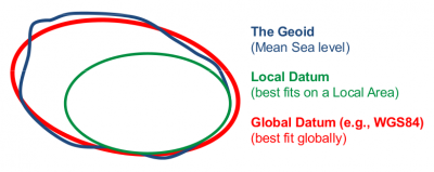
A datum consists in a ellipsoid relative to which the latitude and longitude of points are defined, and a geoid defining the surface at zero height [footnotes 1].Different organisations, countries or groups of countries have developed their own datums for civil and military applications.
Such ellipsoids are conventionally defined as fitting the geoid in the region of interest, without them being necessarily geocentric or to have their axes constrained to a given orientation. A valuable contribution of GPS was to provide a Global Reference Frame, simplifying the mapping of the earth and unifying the diverse datums [Misra & Enge, 2001][1]. Figure 1 illustrates the concept of Local and Global datum, and its relation the geoid.
The ellipsoidal coordinates of the datum must then be mapped into plane coordinates using a proper projection to build a map. Different projections have been defined (preserving areas, angles, distances, etc.), but all of them introduce distortions due to the mapping of a curve surface to a plane (see, for instance, [Hofmann-Wellenhof et al., 2008], chapter 8[2]).
The local maps edited by the official organisms are referenced to a given datum. The coordinates expressed in a datum can be transformed into another with a 7 parameter transformation as explained in Transformation between Celestial and Terrestrial Frames. In this way, most of the commercial receivers incorporate the parameters for several official datums to map the WGS84 coordinates.
Notes
- ^ More precisely, the equipotential surface of earth's gravity field that on average coincides with mean sea level in the open oceans. Note that due to variations in gravity, the geoid undulates significantly.
References
- ^ [Misra and Enge, 2001] Misra, P. and Enge, P., 2001. Global Positioning System. Signals, Measurements and Performance. Ganga-Jamuna Press, Massachusetts, US.
- ^ [Hofmann-Wellenhof et al., 2008] Hofmann-Wellenhof, B., Lichtenegger, H.,K. and Wasle, E., 2008. GNSS - Global Navigation Satellite Systems..Springer-Verlag, Wien, Austria.

