If you wish to contribute or participate in the discussions about articles you are invited to contact the Editor
Category:EGNOS Signal Structure: Difference between revisions
Jon.Caudepon (talk | contribs) No edit summary |
Jon.Caudepon (talk | contribs) No edit summary |
||
| Line 27: | Line 27: | ||
|'''INMARSAT IOR-W''' || 126 || 39 || 25E | |'''INMARSAT IOR-W''' || 126 || 39 || 25E | ||
|} | |} | ||
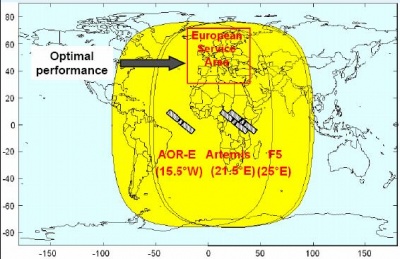
[[File:GEO FootPrints.JPG| EGNOS CDDS : Inmarsat and Artemis EGNOS geostationary broadcast areas |400px|thumb|center]] | |||
==EGNOS SIS RF Characteristics== | ==EGNOS SIS RF Characteristics== | ||
Revision as of 14:00, 25 April 2011
| This category uses the form xxx. |
DescriptionThe EGNOS signal is broadcast by two Inmarsat-3 satellites – one positioned east of the Atlantic, and the other above Africa – and by ESA’s Artemis satellite, which is also above Africa. These three satellites’ orbits are in the equatorial plane, at three different longitudes, with each able to broadcast EGNOS services across the whole ECAC area.[1] Unlike the GPS and GLONASS satellites, these three space platforms carry no signal generators. They are fitted with a transponder which does nothing more than relay the signal processed on the ground and sent into space. EGNOS is fully interoperable with the GPS system, which is currently being modernized to take into account new civil signals on the L5 frequency band that GPS will be transmitting and future Galileo signals. EGNOS SIS Interface CharacteristicsThe EGNOS Signal In Space format is compliant with the ICAO SARPs for SBAS.[1] The following section provides an overview of the EGNOS SIS interface characteristics, related to carrier and modulation radio frequency. Message structure, protocol and content of the EGNOS message are detailed in the EGNOS Message Format definition.
EGNOS SIS RF CharacteristicsGPS/SBAS Signal GeneratorsA range of signal generators were developed in the GNSS Industry as a means to provide flexible platforms for the These products allow to select specific navigation satellite systems, to define influencing error sources, to choose signal frequency and modulations schemes as well as the RF Front end and filter characteristics. The purpose of this generators is to evaluate acquisition and tracking algorithms or receiver HW, to design multipath and interference mitigation strategies. They are easy to integrate on user test environments Some of the most representative product manufacturers are Spirent[2] and Novatel.[3] |
Pages in category "EGNOS Signal Structure"
This category contains only the following page.
