If you wish to contribute or participate in the discussions about articles you are invited to contact the Editor
GLONASS Architecture: Difference between revisions
mNo edit summary |
Rui.Pereira (talk | contribs) No edit summary |
||
| Line 1: | Line 1: | ||
{{Article Infobox2 | {{Article Infobox2 | ||
|Category=GLONASS | |Category=GLONASS | ||
|Authors=GMV | |Authors=GMV | ||
|Level=Basic | |Level=Basic | ||
|YearOfPublication=2011 | |YearOfPublication=2011 | ||
|Logo=GMV | |Logo=GMV | ||
|Title={{PAGENAME}} | |||
}} | }} | ||
[[GLONASS General Introduction|GLONASS]] is a space-based global navigation satellite system (GNSS) that provides reliable positioning, navigation, and timing services to users on a continuous worldwide basis freely available to all. GLONASS receivers compute their position in the [[GLONASS Reference Frame|GLONASS Reference System]] using satellite technology and based on [[An intuitive approach to the GNSS positioning|triangulation principles]]. | [[GLONASS General Introduction|GLONASS]] is a space-based global navigation satellite system (GNSS) that provides reliable positioning, navigation, and timing services to users on a continuous worldwide basis freely available to all. GLONASS receivers compute their position in the [[GLONASS Reference Frame|GLONASS Reference System]] using satellite technology and based on [[An intuitive approach to the GNSS positioning|triangulation principles]]. | ||
| Line 24: | Line 24: | ||
The main functions of the [[GLONASS Space Segment| Space Segment]] are to transmit radio-navigation signals, and to store and retransmit the navigation message sent by the Control Segment. The [[GLONASS General Introduction|GLONASS]] space segment consists of 24 operational satellites, distributed over three orbital planes.<ref> [http://www.sdcm.ru/index_eng.html Russian system of differentional correction and monitoring]</ref> The longitude of ascending node differs by 120 deg from plane to plane and each plane comprises eight satellites, staggered by 45 deg in argument of latitude. The satellites operate in circular orbits at an altitude of 19100-km, an inclination of 64.8 deg and each satellite completes the orbit in approximately 11 hours 15 minutes. | The main functions of the [[GLONASS Space Segment| Space Segment]] are to transmit radio-navigation signals, and to store and retransmit the navigation message sent by the Control Segment. The [[GLONASS General Introduction|GLONASS]] space segment consists of 24 operational satellites, distributed over three orbital planes.<ref> [http://www.sdcm.ru/index_eng.html Russian system of differentional correction and monitoring]</ref> The longitude of ascending node differs by 120 deg from plane to plane and each plane comprises eight satellites, staggered by 45 deg in argument of latitude. The satellites operate in circular orbits at an altitude of 19100-km, an inclination of 64.8 deg and each satellite completes the orbit in approximately 11 hours 15 minutes. | ||
Currently (January 2012), the number of satellites in the constellation is 31, 23 operational, 3 spares, one in commissioning phase, one in flight tests phase and three in maintenance.<ref>[http://www.glonass-center.ru/en/GLONASS/ GLONASS constellation status]</ref> | |||
==GLONASS Ground Segment== | ==GLONASS Ground Segment== | ||
Revision as of 18:34, 23 January 2012
| GLONASS | |
|---|---|
| Title | GLONASS Architecture |
| Author(s) | GMV |
| Level | Basic |
| Year of Publication | 2011 |
GLONASS is a space-based global navigation satellite system (GNSS) that provides reliable positioning, navigation, and timing services to users on a continuous worldwide basis freely available to all. GLONASS receivers compute their position in the GLONASS Reference System using satellite technology and based on triangulation principles.
Introduction
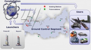
The GLONASS infrastructure consists of:
- A constellation of 24 satellites distributed over three orbital planes;
- the System Control Centre (SSC) located at Krasnoznamensk;
- two Uplink stations;
- the Central Clock situated in Schelkovo (near Moscow)
- a network of four Monitoring and Measuring Stations (MS);
- five Telemetry, Tracking and Control (TT&C) stations.
GLONASS infrastructure is organized in two segments, the Space Segment and the Ground Segment, to be complemented by the users receivers, which compose the User Segment.
GLONASS Space Segment
The main functions of the Space Segment are to transmit radio-navigation signals, and to store and retransmit the navigation message sent by the Control Segment. The GLONASS space segment consists of 24 operational satellites, distributed over three orbital planes.[1] The longitude of ascending node differs by 120 deg from plane to plane and each plane comprises eight satellites, staggered by 45 deg in argument of latitude. The satellites operate in circular orbits at an altitude of 19100-km, an inclination of 64.8 deg and each satellite completes the orbit in approximately 11 hours 15 minutes.
Currently (January 2012), the number of satellites in the constellation is 31, 23 operational, 3 spares, one in commissioning phase, one in flight tests phase and three in maintenance.[2]
GLONASS Ground Segment
The GLONASS Ground Segment (also referred to as Control Segment or Operational Control System) is the responsible for the proper operation of the GLONASS system. It consists of a System Control Centre(SSC); a network of five Telemetry, Tracking and Command centers (TT&C); the Central Clock; three Upload Stations (UL); two Satellite Laser Ranging Stations (SLR); and a network of four Monitoring and Measuring Stations (MS), distributed over the territory of the Russian Federation. Six additional monitoring and measurement stations are to start operating in the near future.[3] This network is complemented by other additional measurement stations on the territory of the Russian Federation, equipped with laser ranging and other monitoring facilities.
Furthermore, the synchronization of all the processes in the GLONASS system is very important for its proper operability. The Central Synchronizer is high-precise hydrogen atomic clock which forms the GLONASS system time scale.
GLONASS User Segment
The GLONASS User Segment consists of L-band radio receiver/processors and antennas which receive GLONASS navigation signals, determine pseudoranges (and other observables), and solve the navigation equations in order to obtain their coordinates and provide a very accurate time.
Although the GLONASS constellation is nearing global coverage, its commercialization, especially development of the user segment, has been lacking compared to the U.S. GPS system.[4] To improve the situation, the Russian government has been actively promoting GLONASS for civilian use. The government is planning to force all car manufactures in Russia to make cars with GLONASS starting from 2011 and they announced, in February 2011, that all passenger cars, large transport vehicles and vehicles transporting dangerous materials will be required to use GLONASS-equipped navigators as of July 2011.[5]
Besides, Russian efforts to improve GLONASS accuracy are getting results, several electronic companies have announced the launching of new receivers supporting GLONASS.[6][7]
Notes
References
- ^ Russian system of differentional correction and monitoring
- ^ GLONASS constellation status
- ^ Current and planned global and regional navigation satellite systems and satellite-based augmentation systems
- ^ GLONASS on Wikipedia
- ^ Ministry of transport want to fine for absence of GLONASS navigators
- ^ Qualcomm Incorporated now has product support for the Russian GLONASS satellite system
- ^ Broadcom announces two new system-on-a-chip solutions with support for GLONASS


