If you wish to contribute or participate in the discussions about articles you are invited to contact the Editor
SBAS Interoperability: Difference between revisions
Jon.Caudepon (talk | contribs) |
Rui.Pereira (talk | contribs) |
(No difference)
| |
Revision as of 15:51, 18 May 2011
| EGNOS | |
|---|---|
| Title | SBAS Interoperability |
| Author(s) | GMV. |
| Level | Basic |
| Year of Publication | 2011 |
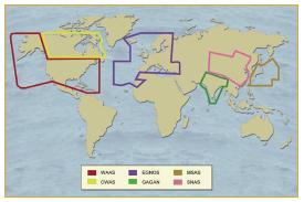
In addition to EGNOS, there are other Satellite Based Augmentation Systems (SBAS) under development: the wide area augmentation system (WAAS) in USA, the multi-functional transport satellite (MTSAT) satellite-based augmentation system (MSAS), in Japan, the GAGAN system in India and the SNAS system in China. Although all SBAS are currently defined as regional systems, it is commonly recognized the need to establish adequate co-operation/co-ordination among the different systems, so that their implementation becomes more effective and part of a seamless world-wide navigation system.[1]
To guarantee seamless and worldwide system provision, it is essential that the existing systems do meet some common interoperability requirements and do provide adequate system. The service providers of the EGNOS, WAAS and MSAS systems are regularly meeting through so called “interoperability working group (IWG)” meetings to conclude on a the precise understanding of the term interoperability, and on the identification of the necessary interfaces among SBAS that each conceivable interoperability scenarios may imply. The EGNOS system achieved.
In addition to interoperability, EGNOS has built-in expansion capability to enable extension of the services over regions within the Geostationary Broadcast Area of GEO satellites used, such as Africa, Eastern countries, and Russia.
The combination of SBAS Interoperability and expansion concepts should allow providing a true global world-wide navigation seamless service.
Other SBAS Systems
In the mid-1990s, three regions took up the gauntlet to develop SBAS systems: Europe, the US, and Japan.[2]
In the United States of America, the Federal Aviation Administration has taken the lead for developing its Wide Area Augmentation System or WAAS. The WAAS signal was made available for non-aviation users in 2000. It currently delivers accuracies of one meter horizontal and two meters vertical and supports aviation precision approach (APV-1) performance. An Initial Operational Capability (IOC) for aviation use started in July 2003 and its Full Operational Capability (FOC) is planned for the end of 2007.
Japan is developing an SBAS founded on its Multi-function Transport Satellite (MTSAT) called the MTSAT Satellite Augmentation System or MSAS. The first phase based on single geostationary satellite coverage is planned for 2005 while the second phase based on dual geostationary satellite coverage is planned for 2006. We expect MSAS to deliver a Non Precision Approach capability, and this could be enhanced to provide precision approach performances (e.g. APV-1).
SBAS System Cooperation
SBAS Interoperability refers to the ability of SBAS systems and the services they provide to be used together to provide better capabilities at the user level than those achieved by relying solely on one of the systems. The SBAS interoperability has always been a prerequisite for delivering a global seamless safety-oflife service.[3]
Although all SBAS are regional systems, it is commonly recognised the need to establish adequate co-operation/coordination among SBAS providers so that their implementation becomes more effective and part of a seamless world-wide navigation system. SBAS co-operation is currently co-ordinated through the so-called Interoperability Working Groups (IWG). Although interoperability implies a large variety of complex issues (such as certification, standards, safety, operations,…), EGNOS, WAAS, CWAAS and MSAS SBAS providers have agreed on the following list of objectives concerning technical interoperability and co-operation among SBAS:[4]
SBAS Interoperability Studies
Being SBAS system interoperability a critical issue, diverse studies are being carried out in order to draw design and operational considerations.
In this context, SBAS service areas will overlap and, considering that there may co-exist different SBAS signals in the boundary regions, two important issues are to be noted:[5]
- SBAS systems may have different SV masks. This is not a problem since the receiver shall maintain an information database per GEO PRN signal and then the transition between one GEO to the other will not be affected by different SV masks.
- Different SBAS system may provide corrections and integrity for different satellite constellations (i.e. GLONASS and GPS). At SARPS level, the information to be broadcast by a service provider both for GPS and GLONASS constellations is defined. However, at MOPS level, there are just minimum operational requirements for airborne navigation equipment using GPS augmented by SBAS. The not-consideration of the GLONASS constellation is a major issue which will have to be properly tackled before a Safety-of-Life service can be provided for GLONASS satellites.
For these reasons, at standards level, SBAS system interoperability is not feasible yet. On the one hand, some of them are not yet ready for Safety
Despite this fact at standards level, there is no major problem for interoperability in any of the operational modes, at present no EGNOS-SDCM interoperability is possible, mainly due to the fact that the systems are not ready to be used for Safety-of-Life and also since SDCM is intended for GLONASS satellites too which are not currently covered by the MOPS standard. Solving these issues will lead to an operational EGNOS/SDCM Interoperability.
Notes
References
- ^ The European EGNOS Project: Mission, Program and System Description; J.Ventura-Traveset, L. Gauthier, F. Toran and P.Michel, ESA EGNOS Project office, European Space Agency (ESA); G. Solari and F. Salabert, Galileo Joint Undertaking (GJU); D. Flament, J. Auroy and D. Beaugnon, Alcatel Alenia Space
- ^ SBAS - Interoperability Explained - Delivering a Global Service
- ^ EEGS Newsletter-September 2010
- ^ Interoperability Test Analysis between EGNOS and MSAS SBAS Systems; Jorge Nieto, Joaquin Cosmen, Ignacio García, GMV, S.A.; Javier Ventura-Traveset, Isabel Neto, European Space Agency (ESA); Bernd Tiemeyer, Nicolas Bondarenco, Eurocontrol Experimental Centre; Kazuaki Hoshinoo, ENRI Institute, Japan
- ^ EEGS Project Web site

