If you wish to contribute or participate in the discussions about articles you are invited to contact the Editor
Maritime Products: Difference between revisions
Jump to navigation
Jump to search
m (moved Maritime Products to Work in Progress:Maritime Products) |
No edit summary |
||
| Line 13: | Line 13: | ||
== Chartplotters == | == Chartplotters == | ||
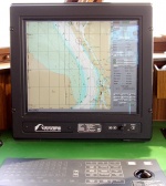
[[File:ECDISTA.jpg|right|thumb|150px|Chartplotter in vessel's deck]] | |||
The GNSS Chartplotters are dedicated devices meant to be used in maritime navigation activities. | The GNSS Chartplotters are dedicated devices meant to be used in maritime navigation activities. | ||
| Line 22: | Line 21: | ||
These products provide assistance in three major nautical activities: maritime en route navigation, collision avoidance (through means of AIS) and fishing activities. | These products provide assistance in three major nautical activities: maritime en route navigation, collision avoidance (through means of AIS) and fishing activities. | ||
Detailed information about | Detailed information about Chartplotters can be found [[Chartplotters|here]]. | ||
== Notes == | == Notes == | ||
Revision as of 17:39, 12 May 2011
| Applications | |
|---|---|
| Title | Maritime Products |
| Author(s) | Rui Barradas Pereira. |
| Level | Medium |
| Year of Publication | 2011 |
Overview of Road Products
Chartplotters
The GNSS Chartplotters are dedicated devices meant to be used in maritime navigation activities.
There are two types of maritime products using GNSS technology, the handheld devices and the chartplotters. There is also the option of using a computer connected to GNSS, loaded with proper software.
These products provide assistance in three major nautical activities: maritime en route navigation, collision avoidance (through means of AIS) and fishing activities.
Detailed information about Chartplotters can be found here.
Notes

