If you wish to contribute or participate in the discussions about articles you are invited to contact the Editor
SBAS Systems: Difference between revisions
No edit summary |
No edit summary |
||
| Line 16: | Line 16: | ||
==WAAS== | ==WAAS== | ||
[[File:waas_log.gif|right|100px|thumb]] | |||
The WAAS was jointly developed by the United States Department of Transportation (DOT) and the Federal Aviation Administration (FAA), beginning in 1994, to provide performance comparable to category I instrument landing system (ILS) for all aircraft possessing the appropriately certified equipment.<ref>[http://en.wikipedia.org/wiki/Wide_Area_Augmentation_System Wide Area Augmentation System]</ref> | |||
==Notes== | ==Notes== | ||
Revision as of 23:22, 31 March 2011
| Fundamentals | |
|---|---|
| Title | SBAS Systems |
| Author(s) | GMV |
| Level | Basic |
| Year of Publication | 2011 |
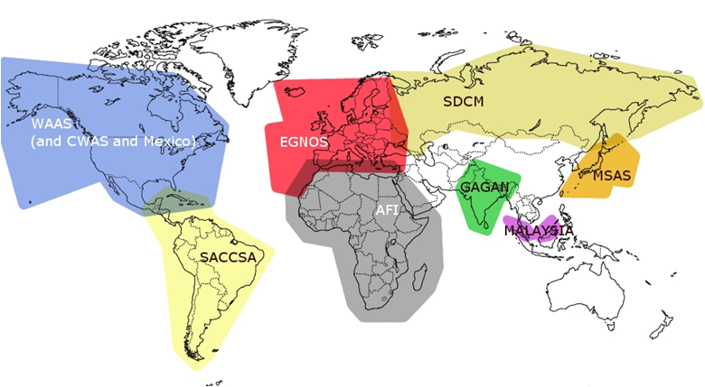
SBAS systems are spreading out all over the world. More and more, it is believed that upon dual-frequency SBAS service provision, a seamless navigation will be possible from and to any two locations in the world.
From all the SBAS systems in the world, three are already operational –WAAS, MSAS, EGNOS– , two are under implementation –GAGAN, SDCM– while the rest are under feasibility studies –SACCSA, AFI.
WAAS
The WAAS was jointly developed by the United States Department of Transportation (DOT) and the Federal Aviation Administration (FAA), beginning in 1994, to provide performance comparable to category I instrument landing system (ILS) for all aircraft possessing the appropriately certified equipment.[1]
Notes

