If you wish to contribute or participate in the discussions about articles you are invited to contact the Editor
Galileo Search and Rescue Service: Difference between revisions
Gema.Cueto (talk | contribs) No edit summary |
Gema.Cueto (talk | contribs) |
||
| Line 78: | Line 78: | ||
The Search and Rescue Transponder on Galileo satellites detects the distress alert from any COSPAS-SARSAT beacon emitting an alert in the 406 – 406.1 MHz band, and broadcasts this information to dedicated ground stations in the “L” band at 1544.71 MHz.<ref name="SAR SDD">[https://www.gsc-europa.eu/sites/default/files/sites/all/files/Galileo-SAR-SDD.pdf Galileo SAR Service Definition Document]</ref> COSPAS-SARSAT Mission Control Centres (MCC) carry out the position determination of the distress alert emitting beacons, once they have been detected by the dedicated ground segment. | The Search and Rescue Transponder on Galileo satellites detects the distress alert from any COSPAS-SARSAT beacon emitting an alert in the 406 – 406.1 MHz band, and broadcasts this information to dedicated ground stations in the “L” band at 1544.71 MHz.<ref name="SAR SDD">[https://www.gsc-europa.eu/sites/default/files/sites/all/files/Galileo-SAR-SDD.pdf Galileo SAR Service Definition Document]</ref> COSPAS-SARSAT Mission Control Centres (MCC) carry out the position determination of the distress alert emitting beacons, once they have been detected by the dedicated ground segment. | ||
Current Galileo SAR Service performance can be expressed in terms of Minimum Performance Levels (MPL) for the contribution to the SAR Forward and Return link services <ref name="SAR SDD">[https://www.gsc-europa.eu/sites/default/files/sites/all/files/Galileo-SAR-SDD.pdf Galileo SAR Service Definition Document]</ref> as it is indicated in the Galileo SAR Service Definition document. In addition, please refer to the SAR Service Quarterly Performance reports <ref name="gsc reports">[https://www.gsc-europa.eu/electronic-library/galileo-service-performance-reports Galileo Performance Reports]</ref> which presents the performances achieved against the aforementioned MPL. | Current Galileo SAR Service performance can be expressed in terms of Minimum Performance Levels (MPL) for the contribution to the SAR Forward and Return link services <ref name="SAR SDD">[https://www.gsc-europa.eu/sites/default/files/sites/all/files/Galileo-SAR-SDD.pdf Galileo SAR Service Definition Document]</ref> as it is indicated in the Galileo SAR Service Definition document. In addition, please refer to the SAR Service Quarterly Performance reports <ref name="gsc reports">[https://www.gsc-europa.eu/electronic-library/galileo-service-performance-reports Galileo Performance Reports]</ref> which presents the performances achieved against the aforementioned MPL {{efn|Let us note that the declaration of the Galileo SAR Return Link Service implied the publication of a new Release of the Galileo SAR Service Definition Document (v2.0). In this new release, the MPLs for the RLS were introduced and some of the MPLs for FLS were modified with respect the first issue of the Galileo SAR SDD from 2016.}}. | ||
==='''<u>Forward Link Service Availability</u>'''=== | ==='''<u>Forward Link Service Availability</u>'''=== | ||
Revision as of 08:13, 26 March 2020
| GALILEO | |
|---|---|
| Title | Galileo Search and Rescue Service |
| Edited by | GMV |
| Level | Basic |
| Year of Publication | 2011 |
Galileo Support to Search and Rescue Service (SAR) represents the contribution of Europe to the international COSPAS-SARSAT co-operative effort on humanitarian Search and Rescue activities as an important player of the Medium Earth Orbit Search and Rescue system (MEOSAR). Galileo is to play an important part of the Medium Earth Orbit Search and Rescue system (MEOSAR). Galileo satellites are able to pick up signals from emergency beacons carried on ships, planes or persons and ultimately send these back to national rescue centres. From this, a rescue centre can know the precise location of an accident. Once the constellation is fully deployed, at least one Galileo satellite will be in view of any point on Earth so near real-time distress alert is possible. In addition to that, Galileo presents a unique feature in comparison to other GNSS systems, since it also provides a Forward Link Alert Service which their distress signal has been received.[1]
Galileo Search and Rescue (SAR) is already available since the declaration of the Galileo Initial Services declaration in December 2016.[2] The Return Link service was declared in January 2020. [3]
The COSPAR-SARSAT Mission
Cospas-Sarsat is an international satellite system for Search and Rescue (SAR) distress alerting that was established in 1979 by Canada, France, the USA and the former USSR. Since then, it has been expanded to other countries wishing to participate, currently gathers 45 countries.
The International COSPAS-SARSAT Programme provides accurate, timely, and reliable distress alert and location data to help search and rescue authorities assist persons in distress. The objective of the Cospas-Sarsat system is to reduce, as far as possible, delays in the provision of distress alerts to Search and Rescue (SAR) services, and the time required to locate a distress and provide assistance, which have a direct impact on the probability of survival of the person in distress at sea or on land.[4]
To achieve this objective, Cospas-Sarsat Participants implement, maintain, co-ordinate and operate a satellite system capable of detecting distress alert transmissions from radiobeacons that comply with Cospas-Sarsat specifications and performance standards, and of determining their position anywhere on the globe. The distress alert and location data is provided by Cospas-Sarsat Participants to the responsible SAR services.
Cospas-Sarsat co-operates with the International Civil Aviation Organization (ICAO), the International Maritime Organization (IMO), the International Telecommunication Union (ITU) and other international organisations to ensure the compatibility of the Cospas-Sarsat distress alerting services with the needs, the standards and the applicable recommendations of the international community.
Since regulations have been adopted requiring the installation of beacons on aircraft or on merchant vessels and fishing boats, more than 1.47 million beacons are in service around the world, which permitted rescuing more than 2000 people only in 2019. [5]
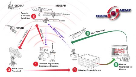
The COSPAS-SARSAT service is composed of four components:[6]
- Beacons: 406 MHz radio transmitting devices: Emergency Position Indicating Radio Beacons (EPIRBs) and Ship Security Alert System (SSAS) for maritime applications, the Emergency Locator Transmitters (ELTs) and ELT Distress Tracking (ELT(DT)) for aviation applications or Personal Locator Beacons (PLBs) for personal use.
- A Space Segment encompassing LEO, GEO and MEO satellites that process and/or relay the signals transmitted by beacons.
- A Ground Segment: a set of ground receiving stations called Local User Terminals (e.g. MEOLUTs for MEOSAR service) which process the broadcast signals and generate independent location estimations of the user in distress.
- Mission Control Centres (MCCs) which contribute to distribute alerts generated by the LUTs via dedicated network connections to other MCCs and to the relevant Rescue Co-ordination Centre (RCC) in charge of the Search and Rescue mission.
Galileo contribution (SAR/Galileo)
The Galileo support to the Search and Rescue service, herein called SAR/Galileo, represents the contribution of Europe to the international COSPAS-SARSAT cooperative effort on humanitarian Search and Rescue activities. SAR/Galileo allows for important improvements of the existing COSPAS-SARSAT system, as it provides:
- near real-time reception of distress messages transmitted from anywhere on Earth (the average waiting time is currently one hour);
- precise location of alerts (a few meters for EPIRBs and ELTs equipped with Galileo receivers, while the current specification for location accuracy is 5 km);
- multiple satellite detection to avoid terrain blockage in severe conditions;
- increased availability of the space segment (27 Medium Earth Orbit satellites on top of the four Low Earth Orbit satellites and the three Geostationary satellites in the current system).
Galileo contribution to COSPAS-SARSAT encompasses the following services:
- SAR/Galileo forward link service (FLS): based on Galileo’s capability to pick up signals emitted from COSPAS-SARSAT compatible 406 MHz distress beacons and relay this information to European MEOLUT, which can provide beacon identification and location estimation information to the associated COSPAS-SARSAT MCCs.
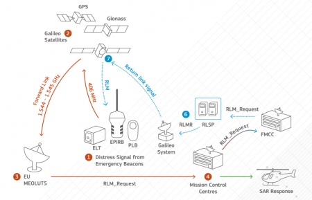
- • In addition, SAR/Galileo introduces a new SAR function, namely the SAR/Galileo Return Link service (RLS)which provides an acknowledgement capability to distress beacons confirming that the alert has been detected and located by the system. This service relies on the Galileo E1-B (I/NAV) navigation signal to transmit the acknowledgement messages to distress beacon and is only available for RLS enabled beacons. Additional Return Link services are foreseen and dedicated service updates will be then provided.
This provides an acknowledgement capability to distress beacons confirming that the alert has been detected and located by the system. This service, which will be provided worldwide, will rely on the Galileo E1-B navigation signal to transmit the acknowledgement messages to distress beacon and will therefore only be available for RLS enabled beacons.
Infrastructure
The SAR/Galileo Forward Link Service is based on the following elements[8][6]:
- SAR Repeater instruments (SARR) onboard the Galileo satellites (22 operational on March 2020), see updated status in Galileo Service Centre (GSC) website [9];
- 3 European MEO Local User Terminals (MEOLUTs) deployed in Maspalomas (Spain), Spitsbergen (Norway) and Larnaca (Cyprus);
- A MEOLUT Tracking Coordination Facility (MTCF) located in the SAR/Galileo Service Centre in Toulouse (France);
- 5 SAR/Galileo Reference Beacons (REFBE) located in Maspalomas (Spain), Spitsbergen (Norway), Larnaca (Cyprus), Toulouse (France) and Santa Maria (Portugal), suited for FLS and RLS service monitoring;
- The SAR/Galileo Network (SARN) and a SAR Server, providing an alternative source of precise Galileo orbital parameters.
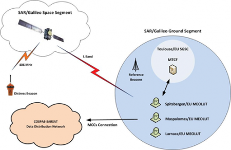
The SAR/Galileo Service fully exploits the signals relayed by the other available MEOSAR payloads to provide increased service availability to the Cospas-Sarsat Mission Control Centres.
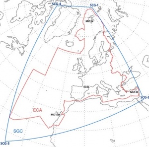
The signals relayed by the MEOSAR satellites are received by the three European MEOLUTs, which ensures the provision of the service over the coverage area (“SAR Galileo Coverage”, blue contour in the following figure), which includes as a minimum all search and rescue areas under the responsibilities of European territories (red contour).
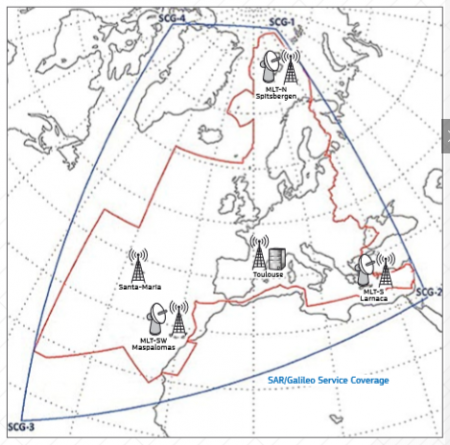
The European SAR/Galileo Coverage area is bounded by the following four geographic coordinates:[6]
- SGC1: 85.00° N 41.20° E in the Arctic Ocean.
- SGC2: 29.18° N 37.07° E in Saudi Arabia.
- SGC3: 05.00° N 38.00° W in the Atlantic Ocean.
- SGC4: 75.76° N 77.87° W in the Baffin Bay.
The SAR/Galileo Return Link service enables a communication link allowing the relay of data back to the originating beacon. This link is irrespective of the COSPAS-SARSAT satellite system used for the independent location confirmation through the Galileo SIS. This service is supported by the new Galileo Service Facility called Return Link Service Provider (RLSP) located in the SAR/Galileo Service Centre (SGSC) in CNES, Toulouse. The RLSP is in charge of securely providing the ground segment interface between the French MCC and Galileo Core Infrastructure, enabling the transmission of Return Link Messages (RLM) through the Galileo Navigation SIS (I/BAV E1) to the appropriate Galileo satellites that are in view of the beacon.
See details on the SAR/Galileo Return Link service operation and on the RLM content in the Galileo SAR Service Definition Document. [6]
Performance and features
The Search and Rescue Transponder on Galileo satellites detects the distress alert from any COSPAS-SARSAT beacon emitting an alert in the 406 – 406.1 MHz band, and broadcasts this information to dedicated ground stations in the “L” band at 1544.71 MHz.[6] COSPAS-SARSAT Mission Control Centres (MCC) carry out the position determination of the distress alert emitting beacons, once they have been detected by the dedicated ground segment.
Current Galileo SAR Service performance can be expressed in terms of Minimum Performance Levels (MPL) for the contribution to the SAR Forward and Return link services [6] as it is indicated in the Galileo SAR Service Definition document. In addition, please refer to the SAR Service Quarterly Performance reports [11] which presents the performances achieved against the aforementioned MPL Template:Efn.
Forward Link Service Availability
The SAR/Galileo Forward Link Service shall be available at least 99% of the time over a period of any one year in the entire SAR/Galileo Coverage Area.
European MEOLUT Facility Availability
The European MEOLUT Facility Availability in nominal mode shall be at least 95% of the time over a period of any year, and at least 97,5% in nominal or degraded mode.
Detection Performance
This feature represents the probability of detecting the transmissions to 406 MHz beacons within the European SAR/Galileo coverage and receiving a valid beacon message by the European MEOLUT. It is measured on the basis of the messages single burst detection probability.
The KPI for detection probability after one transmitted burst for a given beacon over a period is computed as follows: N is the number of transmission sequences (each sequence consists of 12 bursts) during the period that produce at least one valid message after the first transmitted burst. M is the local number of transmission sequences for that beacon. The KPI value is given by the ratio N/M.
The Detection probability after 1 transmitted burst shall be at least 99% of the tine over a period of a calendar month.
Location Performance
The location error is the difference between the real position of a beacon and its position as calculated by any of the SGS MEOLUTs. The location accuracy is defined as the probability to produce a location with an error bounded by a given threshold, namely 2km and 5km, that is the ratio of the locations that are computed with a location error lower than X (2 or 5km), over the total number of computed locations by the SGS.
The probability of locating a burst within X km for a beacon is given by the ratio Q/R with Q the number of localizations with accuracy better than or equal to X km. R is the number of computed localizations in the class.
The system Initial Service location performance expectations are defined in the following table.
| SAR/GALILEO INITIAL SERVICE LOCATION PERFORMANCE | EXPECTED VALUE |
|---|---|
| Location Probability after 1 transmitted burst | > 90% |
| Location Probability after 12 transmitted bursts | > 98% |
| Location Probability after 1 transmitted burst within 5 km | > 90% |
| Location Probability after 12 transmitted bursts within 5 km | > 95% |
For the location minimum performance, the nominal mode networked of SGS is considered, with tacking coordination and TOA/FOA measurements exchange between MEOLUTs. This mean that a location can be computed from data received by any SGS MEOLUT.
Service Performance Requirements
The Service performances requirements for the Galileo Search and Rescue Service are described in next table: [12]
| Galileo support to Search and Rescue Service (SAR/Galileo) | |||
|---|---|---|---|
| Capacity | Each satellite shall relay signals from up to 150 simultaneous active beacons | ||
| Forward System Latency Time | The communication from beacons to SAR ground stations shall allow for the detection and location of a distress transmission in less than 10 min. The latency time goes from beacon first activation to distress location determination. | ||
| Quality of Service | Bit Error Rate < 10e-5 for communication link: beacon to SAR ground station. | ||
| Acknowledgment Data Rate | 6 messages of 100 bits each, per minute. | ||
| Availability | > 99.8% | ||
In the scope of the IOV tests campaign 77 percent of simulated distress locations were pinpointed within 2 kilometres, and 95 percent within 5 kilometres. In addition all alerts were detected and forwarded to the Mission Control Centre within a minute and a half, which largely meets the design requirement of 10 minutes[13].
Implementation
The Galileo Search and Rescue (SAR) Service begun to be tested after the second pair of the Initial Operation Capability (IOC) satellites were put into orbit, since these are the first satellites equipped with SAR search and rescue repeaters. The first successful test was conducted on 17 January 2013 and basically consisted of sending an UHF signal from ESA’s Redu Centre in Belgium and reception of the reply in the L-Band antenna of the ground segment[14]. After that it was signed two contracts for the deployment of the Galileo SAR Ground Stations: the first one on March 2013 with INTA (Spain) for the deployment of the Maspalomas (Spain) Ground Station in, and the second one with KSAT (Norway) on 17 April 2013 in order to develop the Spitsbergen (Svalbard), Norway station.[15].
As of November 2014, the SAR stations at Spitsbergen in the Norwegian Arctic, Maspalomas on the largest island of Spain’s Canary Islands, and Larnaca on the island nation of Cyprus, were given as ready to pick up distress calls via satellite from all across Europe and its surrounding waters. These three station overseen from a control centre in Toulouse, France, are strategically located at the far corners of our continent forming a triangle enclosing Europe. Each site is equipped with four antennas to detect distress calls relayed via satellites in medium-altitude orbits and the three are interlinked to operate jointly, so that all 12 antennas can track satellites together. The efficiency of this approach was confirmed and approved via several tests performed during the summer of 2014.[16]
A new generation of beacons is currently being developed (Second Generation range of Beacons, SGB) to operate with the full capability of the new Meosar Cospas/Sarsat (C/S) International Programme. This system improves significantly the performance of localization introducing new capabilities and new operations impossible before, which will contribute to save more lives at sea and on land. [17]
Notes
References
- ^ Galileo Search and Rescue (SAR) Service in GSA website
- ^ Galileo goes live!
- ^ Galileo SAR Return Link service declaration.
- ^ COSPAS-SARSAT web page
- ^ COSPAS-SARSAT System –data nº45, December 2019
- ^ a b c d e f g h Galileo SAR Service Definition Document
- ^ COSPAS-SARSAT website
- ^ Galileo SAR service in EC Galileo website
- ^ Galileo SAR Constellation status in European GNSS Service Centre (GSC) website
- ^ SAR/Galileo Service coverage and SAR/Galileo Sites
- ^ Galileo Performance Reports
- ^ Galileo Mission High Level Definition, v3, September 2002.
- ^ Galileo Works, And Works Well, ESA, February 2014
- ^ ESA, 23 January 2013
- ^ European Comission, 19 April 2013
- ^ New sites will boost European search and rescue, ESA, 17 November, 2014
- ^ [1], Inside GNSS

