If you wish to contribute or participate in the discussions about articles you are invited to contact the Editor
Other SBAS: Difference between revisions
(→References: better place in category list) |
m (Included editor logo.) |
||
| Line 4: | Line 4: | ||
|Level=Basic | |Level=Basic | ||
|YearOfPublication=2011 | |YearOfPublication=2011 | ||
|Logo=GMV | |||
|Title={{PAGENAME}} | |Title={{PAGENAME}} | ||
}} | }} | ||
Revision as of 17:21, 18 September 2014
| Other SBAS | |
|---|---|
| Title | Other SBAS |
| Edited by | GMV |
| Level | Basic |
| Year of Publication | 2011 |
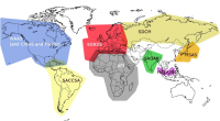
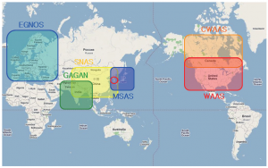
SBAS systems are spreading out all over the world. More and more, it is believed that upon dual-frequency SBAS service provision, a seamless navigation will be possible from and to any two locations in the world.
From all the SBAS systems in the world, three are already operational (WAAS, MSAS and EGNOS), three are under implementation (GAGAN, SDCM, SNAS) while others are under feasibility studies; SACCSA, Malay, African and South Korean SBAS. These last SBAS systems will be explained briefly in this article.
SACCSA
The SBAS initiative in South/Central America and the Caribbean is called SACCSA (Soluciόn de Aumentaciόn para Caribe, Centro y Sudamérica).[1] SACCSA is an ICAO project founded by the Participants/Member States of the SACCSA Project: Argentina, Bolivia, Colombia, Costa Rica, Guatemala, Panama, Spain, Venezuela and COCESNA (Corporación Centroamerica de Servicios de Navegación Aérea). The objective is to study the improvement of the Air Navigation Environment in the Caribbean and South America (CAR/SAM) Regions with a SBAS solution. The program began in 2003 being at present in its Phase III which will determine the feasibility of the implementation of an own SBAS system in the CAR/SAM regions.[2]
SBAS in Malaysia
In Malaysia a future SBAS system is under study.[3] As of 2008, the planned implementation was:[4]
- 2009-2010: Feasibility Study Phase
- 2011-2015: Development Phase
SBAS in Africa
SBAS introduction in Africa aiming to support Air Transport Sector and Satellite Navigation is one of the top priorities of the Africa-European Union cooperation.
During the Seventeenth Meeting of the AFI Planning and Implementation Regional Group (APIRG) in Burkina Faso from 2 to 6 August 2010,[5] the African Commission for Civil Aviation (AFCAC) informed that the provision of SBAS over the Africa-Indian Ocean (AFI) Region was being considered in the frame work of Africa-European Union strategic partnership, and that the implementation plan would be discussed at the third Africa-EU Summit in Libya on 29-30 November 2010. The implementation is studied in terms of an extension of EGNOS system to the AFI Region.[6]
During the third Africa-EU Summit,[7] an action plan for the years 2011-2013 was agreed to implement the Joint Africa EU strategy.[8] As anticipated by AFCAC, this action plan included specific tasks on SBAS as part of the priority number 2 of the partnership on infrastructure. In particular, the following action was stated (verbatim):[8]
- For SBAS, setup and activity of Working Groups, staffing of African GNSS programme management entity, training of African experts, preliminary backbone infrastructure development and initial operations.
The expected result is:[8]
- Building of core technical capacity for SBAS (Satellite Based Augmentation Service) within relevant African organizations in each region and implementation of preliminary backbone infrastructure.
According to the JAES action plan, the list of entities involved in these activities comprises:[8]
- African Union Commission (AUC).
- Regional Economic Communities (RECs).
- United Nations Economic Commission for Africa (UNECA).
- Agence pour la Sécurité de la Navigation Aérienne en Afrique et à Madagascar (ASECNA).
- African Civil Aviation Commission (AFCAC).
- Arab Civil Aviation Commission (ACAC).
- European Space Agency (ESA).
- European Aviation Safety Agency (EASA).
- Single European Sky ATM Research Joint Undertaking (SESAR JU) .
The South African National Space Agency (SANSA) is conducting studies for an SBAS system. The SATSA project (SBAS Awareness and Training for South Africa) is one example for which two main goals have been defined:
- Offer training on satellite and augmentation systems
- To gain knowledge about the main advantages that the SBAS technology can bring to South Africa throughout several applications that required improve accuracy.
SBAS In South Korea
The Korean territory is located between Japan and China and therefore both SBAS Systems of these countries, MSAS and SNAS can be used in Korea[9][10].
As an example, the MSAS vertical and horizontal positioning results at Daejon city, located at the center of Korea, were estimated. Both vertical and horizontal position accuracies are considerably improved and as good as in Japan. The corresponding vertical/horizontal position errors are 1.04/2.09 meters compared to 1.19/1.99 meters in Japan. Therefore, it could be argued that it is not necessary for Korea to develop its own SBAS. However, MSAS performance is not certified in the Korean region, so using MSAS in Korea can cause a critical safety problem. In addition the Localizer performance vertical (LPV) availability at Korean region is not sufficiently high. In 2011 was 90.6% at Usuda, Japan, and 49.4% at Daejon, Korea because Korea is located far from the center of the MSAS service area. For this reason, the Korean government decided to develop its own system and recently resumed the wide area differential global positioning system (WADGPS) development project which will serve as a starting point for the SBAS System development. The main goal of the WADGPS project is to show the capability of using the pseudo-lite and existing NDGPS infrastructures in real-time. The project is scheduled for 2010 to 2014 under contract with the Ministry of Land, Transport and Maritime Affairs (MLTM). After the conclusion of this project Korea will launch a geostationary multifunctional satellite with a navigation payload able to broadcast augmenting signals, according to the National GNSS Master Plan and Space Vision 2016 program[10].
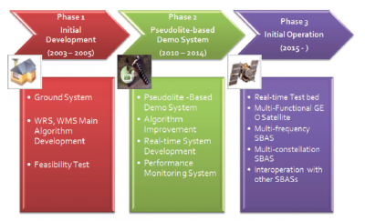
The development phase of the Korean WADGPS project can be divided into 3 phases, as depicted in the figure[10].
Phase 1 is the initial development phase. In this phase was successfully developed the WRS, WMS main algorithms and secured the core technologies of ground systems. Currently, the project is in phase 2, in which some algorithms are improved. The real-time system and performance monitoring system are also developed in phase 2, as well the technology of the ground system and pseudo-lite broadcasting system. After phase 2, a multi-functional GEO satellite will be launched according to the National GNSS Master Plan and Space Vision 2016 program. In this phase, Korean SBAS will start the initial operation and the algorithms will be developed to have a capability of handling multi-frequency and multi-constellation. The pseudo-lite broadcasting system, developed in phase 2, can be used in the location where the GEO satellite signals are blocked because of geographical features or obstacles. This pseudo-lite broadcasting system can solve the SBAS GEO satellite visibility problem effectively[10].
The coverage of the SBAS System under development in China SNAS also includes the Korean territory and therefore it can be used in Korean. Currently there are no data about the performance of the Chinese SBAS System in Korea but it is thought that would not be sufficiently acceptable.
References
- ^ SACCSA homepage
- ^ Agenda of the Seventh Coordination Board Meeting of the SACCSA project, ICAO's South American Office, Lima, Peru
- ^ Announcement of Workshop on Ionospheric Modeling for Malaysian SBAS, December 2010, ANGKASA homepage
- ^ Update on Malaysian GNSS Infrastructure, Presentation at ICG-3 Meeting, Pasadena, USA, December 2008.
- ^ Seventeenth Meeting of APIRG (APIRG/17), Ouagadougou, Burkina Faso, 2–6 August 2010)
- ^ ICAO paper of an independent cost-benefit benefit analysis for an AFI SBAS
- ^ Homepage of the 3rd Africa-EU Summit
- ^ a b c d Joint Africa EU Strategy Action Plan 2011-2013
- ^ BeiDou Navigation Satellite System, Open Service Performance Standard, Version 1.0, China Satellite Navigation Office, December 2013
- ^ a b c d Korean Wide Area Differential Global Positioning System Development Status and Preliminary Test Results, Ho Yun, Changdon Kee, Technical Paper - Int’l J. of Aeronautical & Space Sci., 2011


