If you wish to contribute or participate in the discussions about articles you are invited to contact the Editor
Satellite Formation Flying: Difference between revisions
Carlos.Lopez (talk | contribs) No edit summary |
m (Included editor logo.) |
||
| Line 4: | Line 4: | ||
|Level=Intermediate | |Level=Intermediate | ||
|YearOfPublication=2011 | |YearOfPublication=2011 | ||
|Logo=GMV | |||
|Title={{PAGENAME}} | |Title={{PAGENAME}} | ||
}} | }} | ||
Revision as of 16:28, 18 September 2014
| Applications | |
|---|---|
| Title | Satellite Formation Flying |
| Edited by | GMV |
| Level | Intermediate |
| Year of Publication | 2011 |
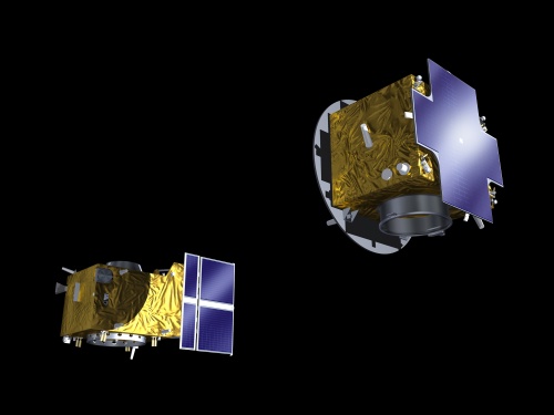
All space missions are difficult. Docking a pair of spacecraft is tough but flying multiple satellites together in formation is the real cutting edge. In formation flying separate expensive pieces of hardware, each one zipping through space at several kilometres per second, may have to maneuverer to within meters of each other to achieve their goals[1].
The relative positions of the satellites must be maintained precisely as they close in: lose control of one part of the formation, even momentarily, and the satellites risk destruction. And orbital dynamics dictate the satellites’ orbits will tend to cross as they circle Earth, another worrying factor for their controllers[1].
Application Architecture
In GNSS formation flying 2 different approaches can be possible depending on the formation characteristics:
- Ground-based control - In ground based control, the GNSS measurements are sent by each satellite on the formation to the ground control center that will commands the satellites to maneuver into the adequate position in the formation. This approach is adequate for formations with separation between spacecrafts on the order of kilometers that don't require a dynamic adjustment of the orbits. The interval between adjustment maneuvers might be of months.
- Autonomous - In autonomous flying formations the measurements are broadcasted between spacecrafts allowing the spacecrafts to calculate their relative positions in the formation and use the Attitude and Orbit Control Systems (AOCS) to maneuver into the adequate position. This approach is adequate for tighter formations that require more frequent and autonmous adjustment of their relative positions. This approach is more difficult and riskier since the tight link between GNSS receiver and the guidance systems can lead to unforeseen interactions causing the loss of control or destruction of the spacecrafts.
GNSS formation flying benefits from the fact that relative positioning is usual more accurate that absolute positioning since being the spacecrafts in proximity it is likely that the measurements from each spacecraft share correlated errors that would be canceled in the relative positioning solution.
Application Characterization
Different types of formation can be envisioned for formation flying. The type of formation, the separation between vehicles and the intended application will have an impact on the formation flying approach. The three most common type of formations are[2]:
- Trailing - Trailing formation are formations were the same orbit is shared and the spacecrafts follow each other path at a specified distance.
- Clusters - In which a group of satellites are located close to each other following orbits that permit them to remain as a cluster.
- Constellation - Constellations normally consist on a set of satellites organized orbital planes that cover the entire Earth. Each orbital plane usually contains the number of satellites required to provide a full coverage for the service being provided. GPS is the most notorious example of a constellation.
Application Examples
- Proba-3 - PROBA-3 is the third satellite mission in the European Space Agency's series of PROBA low-cost satellites that are being used to validate new spacecraft technologies while also carrying scientific instruments. Currently PROBA-3 is in its preparatory study phase. PROBA-3 will show the technology that is required for formation flying of two or more spacecraft[3].
- GRACE - The Gravity Recovery And Climate Experiment (GRACE), a joint mission of NASA and the German Space Agency, has been making detailed measurements of Earth's gravity field since its launch in March 2002. Uses 2 trailing satellites and uses the variation of the distance between the satellites to detect changes in the Earth's gravitational pull.
Notes
References
- ^ a b Simulating the formation-flying future of space, ESA Portal, September 2010
- ^ The Remote Sensing Tutorial - Satellite Formation Flying; NPOESS, Nicholas Short, NASA
- ^ Proba-3 in Wikipedia

