If you wish to contribute or participate in the discussions about articles you are invited to contact the Editor
IRNSS Signal Plan: Difference between revisions
Carlos.Lopez (talk | contribs) No edit summary |
Gema.Cueto (talk | contribs) No edit summary |
||
| Line 6: | Line 6: | ||
|Title={{PAGENAME}} | |Title={{PAGENAME}} | ||
}} | }} | ||
The | In this article are described the signals corresponding to the Indian Regional Navigational Satellite System (IRNSS), which is a regional satellite navigation system owned by the Indian government. The system is being developed by Indian Space Research Organization (ISRO). | ||
In April 2016, with the last launch of the constellation's satellite, IRNSS was renamed Navigation Indian Constellation (NAVIC) by India’s Prime Minister Narendra Modi.<ref> [http://gpsworld.com/with-irnss-1g-launch-india-completes-and-renames-its-navigation-constellation/ With IRNSS-1G launch, India completes and renames its navigation constellation]</ref> | |||
The messaging service signals from the Indian Regional Navigation Satellite System (IRNSS) are broadcast in L5 and S band frequenciesy. The carrier frequency and the bandwidth of transmission for the messaging service are:<ref name="IRNSS ICD">[https://www.isro.gov.in/sites/default/files/article-files/irnss-programme/sis_icd_irnss1a_incois_isro_v1.1_19jul2019.pdf IRNSS Signal-In-Space ICD v1.1]</ref> | |||
{| class="wikitable" align="center" | |||
|+align="bottom" |''IRNSS Carrier Frequencies and bandwidths'' | |||
|- | |||
! Signal | |||
! Carrier Frequency | |||
! Bandwidth | |||
|- align="center" | |||
| L5 | |||
| 1176.45 MHz | |||
| 24 MHz (1164.45 -1188.45 MHz) | |||
|- align="center" | |||
| S | |||
| 2492.028MHz | |||
| 16.5 MHz (2483.778 - 2500.278 MHz) | |||
|} | |||
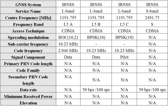
::::[[File: QZSS_Sig_Plan_Table_2.png|none|thumb|580px|'''''Table 1:''''' IRNSS L5 Band technical characteristics.]] | ::::[[File: QZSS_Sig_Plan_Table_2.png|none|thumb|580px|'''''Table 1:''''' IRNSS L5 Band technical characteristics.]] | ||
Revision as of 07:28, 21 April 2021
| Fundamentals | |
|---|---|
| Title | IRNSS Signal Plan |
| Author(s) | J.A Ávila Rodríguez, University FAF Munich, Germany. |
| Level | Advanced |
| Year of Publication | 2011 |
In this article are described the signals corresponding to the Indian Regional Navigational Satellite System (IRNSS), which is a regional satellite navigation system owned by the Indian government. The system is being developed by Indian Space Research Organization (ISRO).
In April 2016, with the last launch of the constellation's satellite, IRNSS was renamed Navigation Indian Constellation (NAVIC) by India’s Prime Minister Narendra Modi.[1]
The messaging service signals from the Indian Regional Navigation Satellite System (IRNSS) are broadcast in L5 and S band frequenciesy. The carrier frequency and the bandwidth of transmission for the messaging service are:[2]
| Signal | Carrier Frequency | Bandwidth |
|---|---|---|
| L5 | 1176.45 MHz | 24 MHz (1164.45 -1188.45 MHz) |
| S | 2492.028MHz | 16.5 MHz (2483.778 - 2500.278 MHz) |
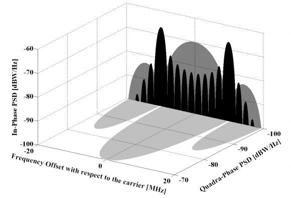
Given the similarity with the Galileo signals in terms of services that IRNSS might be providing, the same convention as for Galileo was employed. That is A for the PRS and B and C for the Open Service data and pilot signals respectively. Furthermore, the spectral properties of the IRNSS signal would be as follows:
To conclude, it is interesting to mention that the Indian Satellite Navigation Programme has been doing much work in the past years on ionospheric and tropospheric modelling in the Region of India what could mean that IRNSS does not plan to use dual frequency at least in the first generation.
Moreover, India also plans to transmit similar signals for the S-band to those we have just described for the L5 band. The carrier frequency of S-band is at 2491.75 MHz. The modulation schemes and data rates would be the same as for L5 but no final decision on the other parameters has been made yet. In addition, it seems that India also plans to transmit signals in L1 as announced during the second Meeting of the ICG in India, in 2007.
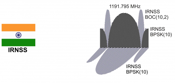
As a summary of the studied regional satellite systems so far, the signal plan IRNSS is shown in the next figure:
References
Credits
The information presented in this NAVIPEDIA’s article is an extract of the PhD work performed by Dr. Jose Ángel Ávila Rodríguez in the FAF University of Munich as part of his Doctoral Thesis “On Generalized Signal Waveforms for Satellite Navigation” presented in June 2008, Munich (Germany)


