If you wish to contribute or participate in the discussions about articles you are invited to contact the Editor
GNSS:Tools: Difference between revisions
mNo edit summary |
No edit summary |
||
| (4 intermediate revisions by 2 users not shown) | |||
| Line 1: | Line 1: | ||
:[[File:TM-23_vol_I_and_II_cover_node_full_image.gif|left|300px]] | :[[File:TM-23_vol_I_and_II_cover_node_full_image.gif|left|300px|link=]] | ||
ESA GNSS Data Processing Book - TM-23: this two-volume book contains a self-learning course and software tools aimed at providing the necessary background to start work in an operative way in GNSS navigation. The books are focused on the instrumental use of concepts and techniques involved in GNSS navigation and include all the elements needed to understand how the system works and how to work with it. After working through the two volumes, students should be able to develop their own tools for high-accuracy navigation, implementing the algorithms and expanding the skills learned. | |||
The first volume is devoted to theory, providing a summary of GNSS fundamentals and algorithms. The second volume is devoted to laboratory exercises, with a wide range of selected practical examples going further into the theoretical concepts and their practical implementation. The exercises have been developed with a specialised software package (the ESA/U PC gLAB educational SW, on | The [http://gssc.esa.int/navipedia/GNSS_Book/ESA_GNSS-Book_TM-23_Vol_I.pdf first volume (8MB)] is devoted to theory, providing a summary of GNSS fundamentals and algorithms. The [http://gssc.esa.int/navipedia/GNSS_Book/ESA_GNSS-Book_TM-23_Vol_II.pdf second volume (28 MB)] is devoted to laboratory exercises, with a wide range of selected practical examples going further into the theoretical concepts and their practical implementation. The exercises have been developed with a specialised software package (the ESA/U PC gLAB educational SW, on a [http://gssc.esa.int/navipedia/GNSS_Book/CDROM_ESA_GNSS-Book_TM-23_Vol_II.iso CD (487 MB)]) and selected data files are provided for the laboratory sessions. | ||
This is an end-to-end GNSS course addressed to all professionals and students who wish to undertake a deeper study of satellite navigation, targeting the GNSS data processing and analysis issues. | This is an end-to-end GNSS course addressed to all professionals and students who wish to undertake a deeper study of satellite navigation, targeting the GNSS data processing and analysis issues. | ||
| Line 12: | Line 11: | ||
:[[File:gLAB.png|none|360px]] | :[[File:gLAB.png|none|360px|link=]] | ||
::[[File:gLAB_Photo.png|right|400px]] | ::[[File:gLAB_Photo.png|right|400px|link=]] | ||
gLAB is a software tool suite developed under an European Space Agency (ESA) Contract by the research group of Astronomy and Geomatics (gAGE) from the Universitat Politecnica de Catalunya (UPC). gLAB is an interactive educational multipurpose package to process and analyse GNSS data. | gLAB is a software tool suite developed under an European Space Agency (ESA) Contract by the research group of Astronomy and Geomatics (gAGE) from the Universitat Politecnica de Catalunya (UPC). gLAB is an interactive educational multipurpose package to process and analyse GNSS data. | ||
| Line 28: | Line 27: | ||
:[[File:SBAS_Sim.png|none|360px]] | :[[File:SBAS_Sim.png|none|360px|link=]] | ||
| Line 39: | Line 38: | ||
Please, visit the following the [http://www.egnos-pro.esa.int/sbassimulator/index.html SBAS Simulator webpage] for more information and a direct download. | Please, visit the following the [http://www.egnos-pro.esa.int/sbassimulator/index.html SBAS Simulator webpage] for more information and a direct download. | ||
::[[File:SBAS_Sim_Photo.png|none|400px]] | ::[[File:SBAS_Sim_Photo.png|none|400px|link=]] | ||
| Line 45: | Line 44: | ||
:[[File:SBAS_Teacher.png|none|360px]] | :[[File:SBAS_Teacher.png|none|360px|link=]] | ||
ESA in association with Iguassu software systems has developed a simple tool, aptly named the SBAS TeACHER (SBAS Tool for Education And Contributor to Harness EGNOS Research). Using this tool the different EGNOS SBAS messages can be decoded and encoded. A snapshot of the Tool is shown here. | ESA in association with Iguassu software systems has developed a simple tool, aptly named the SBAS TeACHER (SBAS Tool for Education And Contributor to Harness EGNOS Research). Using this tool the different EGNOS SBAS messages can be decoded and encoded. A snapshot of the Tool is shown here. | ||
| Line 51: | Line 50: | ||
More information and a direct download can be found in the [http://www.egnos-pro.esa.int/sbasteacher/index.html SBAS TeACHER webpage]. | More information and a direct download can be found in the [http://www.egnos-pro.esa.int/sbasteacher/index.html SBAS TeACHER webpage]. | ||
::[[File:SBAS_Teacher_Photo.png|none|400px]] | ::[[File:SBAS_Teacher_Photo.png|none|400px|link=]] | ||
| Line 59: | Line 58: | ||
:[[File:SBAS_Mentor.png|none|360px]] | :[[File:SBAS_Mentor.png|none|360px|link=]] | ||
ESA in association with Iguassu software systems has developed a simple tool, aptly named the SBAS MeNTOR (SBAS MEssage GENeraTOR). This tool is an evolution of the [http://www.egnos-pro.esa.int/sbasteacher/index.html SBAS TeACHER] and allows to create or decode a sequence of SBAS messages over a selected time period. While the SBAS TeACHER allows to encode or decode one SBAS message at a time, the SBAS MeNTOR can work with EMS like files for data over a selected time period. A snapshot of the Tool is shown here. | ESA in association with Iguassu software systems has developed a simple tool, aptly named the SBAS MeNTOR (SBAS MEssage GENeraTOR). This tool is an evolution of the [http://www.egnos-pro.esa.int/sbasteacher/index.html SBAS TeACHER] and allows to create or decode a sequence of SBAS messages over a selected time period. While the SBAS TeACHER allows to encode or decode one SBAS message at a time, the SBAS MeNTOR can work with EMS like files for data over a selected time period. A snapshot of the Tool is shown here. | ||
| Line 66: | Line 65: | ||
Please, visit the following the [http://www.egnos-pro.esa.int/sbasmentor/index.html SBAS MeNTOR webpage] for more information and a direct download. | Please, visit the following the [http://www.egnos-pro.esa.int/sbasmentor/index.html SBAS MeNTOR webpage] for more information and a direct download. | ||
::[[File:SBAS_Mentor_Photo.png|none|400px]] | ::[[File:SBAS_Mentor_Photo.png|none|400px|link=]] | ||
---- | ---- | ||
| Line 72: | Line 71: | ||
:[[File:SBAS_Sisnetlab.png|none|360px]] | :[[File:SBAS_Sisnetlab.png|none|360px|link=]] | ||
SISNeTlab is a new software tool that allows users to quickly and easily assess the performance of various SBAS systems. It gives the user a wide variety of functionalities and the graphs produced can help in comparing and better understanding the various SBAS systems. | SISNeTlab is a new software tool that allows users to quickly and easily assess the performance of various SBAS systems. It gives the user a wide variety of functionalities and the graphs produced can help in comparing and better understanding the various SBAS systems. | ||
| Line 80: | Line 79: | ||
Direct download and more information about SISNeTlab [http://www.egnos-pro.esa.int/sisnetlab/index.html here] | Direct download and more information about SISNeTlab [http://www.egnos-pro.esa.int/sisnetlab/index.html here] | ||
::[[File:SBAS_Sisnetlab_Photo.png|none|400px]] | ::[[File:SBAS_Sisnetlab_Photo.png|none|400px|link=]] | ||
---- | ---- | ||
:[[File:SBAS_Sisnet_UAS.png|none|360px]] | :[[File:SBAS_Sisnet_UAS.png|none|360px|link=]] | ||
ESA SISNeT UAS (User Application Tool) allow the users to see the contents of the various message types broadcast by EGNOS in real time. | ESA SISNeT UAS (User Application Tool) allow the users to see the contents of the various message types broadcast by EGNOS in real time. | ||
Direct download and more information about SISNeT UAS [http://www.egnos-pro.esa.int/sisnet/uas.html here] | Direct download and more information about SISNeT UAS [http://www.egnos-pro.esa.int/sisnet/uas.html here] | ||
::[[File:SBAS_Sisnet_UAS_Photo.png|none|400px]] | ::[[File:SBAS_Sisnet_UAS_Photo.png|none|400px|link=]] | ||
---- | ---- | ||
::[[File:EGNOStoolkits.png|none|600px]] | ::[[File:EGNOStoolkits.png|none|600px|link=]] | ||
The EGNOS Toolkit offers a set of tools, to help developing EGNOS-capable positioning applications while understanding the full processing chain from reception of raw GNSS satellite data to the computation of the position with EGNOS algorithms. | The EGNOS Toolkit offers a set of tools, to help developing EGNOS-capable positioning applications while understanding the full processing chain from reception of raw GNSS satellite data to the computation of the position with EGNOS algorithms. | ||
| Line 104: | Line 103: | ||
::[[File:Bnc.png|none|400px]] | ::[[File:Bnc.png|none|400px|link=]] | ||
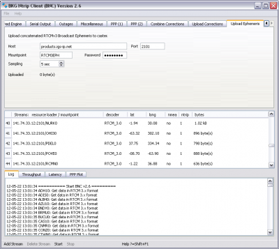
The BNC (BKG Ntrip Client) is a tool that is able to decode and convert real-time GNSS data streams retrieved from NTRIP broadcasters, provided under GNU GPL License. | The BNC (BKG Ntrip Client) is a tool that is able to decode and convert real-time GNSS data streams retrieved from NTRIP broadcasters, provided under GNU GPL License. | ||
After retrieving real-time GNSS data streams, this tool can be used, among other things, to generate Rinex Observation and Navigation files of reference stations. | After retrieving real-time GNSS data streams, this tool can be used, among other things, to generate Rinex Observation and Navigation files of reference stations. | ||
For more information about BNC and direct download please check [http://software.rtcm-ntrip.org/export/HEAD/ntrip/trunk/BNC/src/bnchelp.html here]. | For more information about BNC and direct download please check [http://software.rtcm-ntrip.org/export/HEAD/ntrip/trunk/BNC/src/bnchelp.html here]. | ||
Latest revision as of 09:49, 26 June 2018
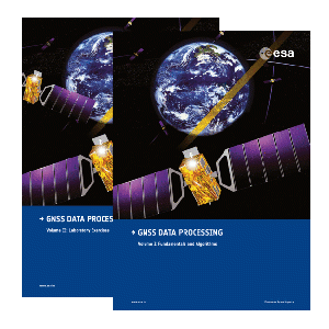
ESA GNSS Data Processing Book - TM-23: this two-volume book contains a self-learning course and software tools aimed at providing the necessary background to start work in an operative way in GNSS navigation. The books are focused on the instrumental use of concepts and techniques involved in GNSS navigation and include all the elements needed to understand how the system works and how to work with it. After working through the two volumes, students should be able to develop their own tools for high-accuracy navigation, implementing the algorithms and expanding the skills learned.
The first volume (8MB) is devoted to theory, providing a summary of GNSS fundamentals and algorithms. The second volume (28 MB) is devoted to laboratory exercises, with a wide range of selected practical examples going further into the theoretical concepts and their practical implementation. The exercises have been developed with a specialised software package (the ESA/U PC gLAB educational SW, on a CD (487 MB)) and selected data files are provided for the laboratory sessions.
This is an end-to-end GNSS course addressed to all professionals and students who wish to undertake a deeper study of satellite navigation, targeting the GNSS data processing and analysis issues.
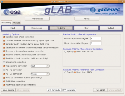
gLAB is a software tool suite developed under an European Space Agency (ESA) Contract by the research group of Astronomy and Geomatics (gAGE) from the Universitat Politecnica de Catalunya (UPC). gLAB is an interactive educational multipurpose package to process and analyse GNSS data.
gLAB performs precise modeling of GNSS observables (pseudorange and carrier phase) at the centimetre level, allowing both standalone GPS positioning and PPP. Every single error contributor may be assessed independently, which, in turn, provides a major educational benefit. gLAB is adapted to a variety of standard formats like RINEX-3.00, SP3, ANTEX and SINEX files, among others. Moreover, functionality is also included for GPS, Galileo and GLONASS, allowing performing some data analysis with real multi-constellation data.
The gLAB software tool is quite flexible, able to run under Linux and Windows operating systems and is provided free of charge by ESA Education Office to universities and GNSS professionals.
gLAB User Manual, Source Code and gLAB Data Processing Lab exercises can be found in the gLAB webpage
The SBAS Simulator has been developed as a result of a collaboration between ESA and IGUASSU Software Systems.
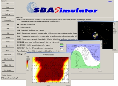
SBAS Simulator is a satellite based navigation systems simulation software. The main concept which led to the creation of the SBAS Simulator was to allow understanding and learning SBAS systems. Therefore, the tool is dedicated to everybody, from general to professional, with an interest in SBAS systems.
SBAS Simulator is a system volume simulator which allows providing performance based on simplified macro models for ECAC region. The performances over regions are only an approximation with no guarantee of the obtained results. With this understanding, the user can freely access the SBAS Simulator tool.
Please, visit the following the SBAS Simulator webpage for more information and a direct download.
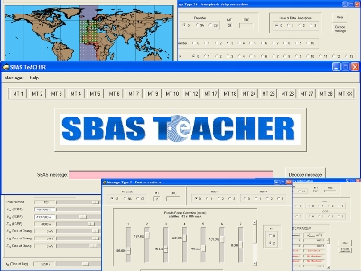
ESA in association with Iguassu software systems has developed a simple tool, aptly named the SBAS TeACHER (SBAS Tool for Education And Contributor to Harness EGNOS Research). Using this tool the different EGNOS SBAS messages can be decoded and encoded. A snapshot of the Tool is shown here.
More information and a direct download can be found in the SBAS TeACHER webpage.
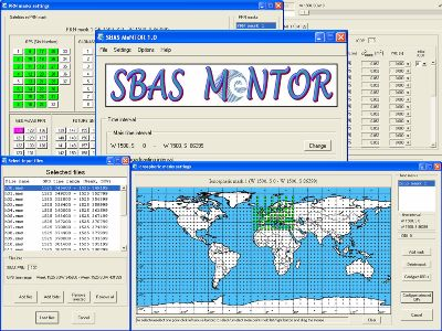
ESA in association with Iguassu software systems has developed a simple tool, aptly named the SBAS MeNTOR (SBAS MEssage GENeraTOR). This tool is an evolution of the SBAS TeACHER and allows to create or decode a sequence of SBAS messages over a selected time period. While the SBAS TeACHER allows to encode or decode one SBAS message at a time, the SBAS MeNTOR can work with EMS like files for data over a selected time period. A snapshot of the Tool is shown here.
Please, visit the following the SBAS MeNTOR webpage for more information and a direct download.
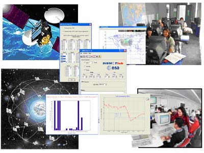
SISNeTlab is a new software tool that allows users to quickly and easily assess the performance of various SBAS systems. It gives the user a wide variety of functionalities and the graphs produced can help in comparing and better understanding the various SBAS systems.
The ESA SISNeTlab software has been developed by the European Space Agency Engineers, as a tool that could serve a wide user community of students, research scientists, Small Medium Enterprises (SMEs) and engineers involved in the development and exploitation of the various SBAS systems.
Direct download and more information about SISNeTlab here
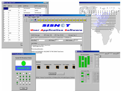
ESA SISNeT UAS (User Application Tool) allow the users to see the contents of the various message types broadcast by EGNOS in real time. Direct download and more information about SISNeT UAS here
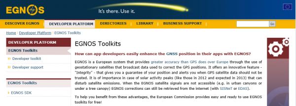
The EGNOS Toolkit offers a set of tools, to help developing EGNOS-capable positioning applications while understanding the full processing chain from reception of raw GNSS satellite data to the computation of the position with EGNOS algorithms. Three EGNOS toolkits (EGNOS SDK, PEGASE tool and SIGNATURE tool) are available here.
The BNC (BKG Ntrip Client) is a tool that is able to decode and convert real-time GNSS data streams retrieved from NTRIP broadcasters, provided under GNU GPL License. After retrieving real-time GNSS data streams, this tool can be used, among other things, to generate Rinex Observation and Navigation files of reference stations. For more information about BNC and direct download please check here.
