If you wish to contribute or participate in the discussions about articles you are invited to contact the Editor
Other Applications: Difference between revisions
Rui.Pereira (talk | contribs) mNo edit summary |
Rui.Pereira (talk | contribs) mNo edit summary |
||
| Line 25: | Line 25: | ||
[[File:Galileo Art.png|right|thumb|200px|Atmospheric Sensing]] | [[File:Galileo Art.png|right|thumb|200px|Atmospheric Sensing]] | ||
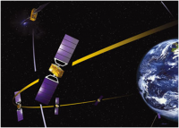
Earth-orbiting satellites have been equipped with Global Positioning System (GPS) receivers for many years now, mostly as an aid for orbit determination. The receiver processes the signals from visible GPS satellites through one or more antennas mounted on the satellite. For GPS satellites that appear to the receiver to be close to the Earth’s horizon, the signals travel through the Earth’s atmosphere and are therefore less useful for orbit determination. However, such signals can be exploited for sounding the upper atmosphere by measuring how they are affected<ref name="SoundAtm">[http://www.esa.int/esapub/bulletin/bulletin126/bul126g_zandbergen.pdf|Sounding the Atmosphere - Ground Support for GNSS Radio-Occultation Processing], ESA Bulletin 126, May 2006</ref>. | Earth-orbiting satellites have been equipped with Global Positioning System (GPS) receivers for many years now, mostly as an aid for orbit determination. The receiver processes the signals from visible GPS satellites through one or more antennas mounted on the satellite. For GPS satellites that appear to the receiver to be close to the Earth’s horizon, the signals travel through the Earth’s atmosphere and are therefore less useful for orbit determination. However, such signals can be exploited for sounding the upper atmosphere by measuring how they are affected as they travel through the atmosphere<ref name="SoundAtm">[http://www.esa.int/esapub/bulletin/bulletin126/bul126g_zandbergen.pdf|Sounding the Atmosphere - Ground Support for GNSS Radio-Occultation Processing], ESA Bulletin 126, May 2006</ref>. | ||
Detailed information about Atmospheric Sensing can be found [[Atmospheric Sensing|here]]. | Detailed information about Atmospheric Sensing can be found [[Atmospheric Sensing|here]]. | ||
Revision as of 16:33, 16 September 2011
| Applications | |
|---|---|
| Title | Other Applications |
| Author(s) | GMV. |
| Level | Medium |
| Year of Publication | 2011 |
The main objective of GNSS systems is to provide positioning but by design other information is available or can be derived from the measurements gathered by GNSS receivers. This led to less conventional uses of the technology in application areas that were not initially envisioned.
By design GNSS systems deliver precise time along with the position and velocity of the user. This capability has been used to provide a precise time reference in different areas such as financial transactions and stock markets. One other example of a less conventional use of GNSS technology is the use of the measured interference of the atmosphere on the GNSS signals to do atmospheric sensing.
Precise Time Reference
GNSS technologies have a design dependence on accurate timing. The resolution of positioning equations depend on the accurate timestamping of GNSS messages and the four variables resolved by positioning equations are: time plus the 3D position coordinates. Each navigation satellite has atomic clocks that are synchronized from a master clock on the ground and the navigation messages are timestamped with the transmission time of the signal.
This allows GNSS receivers to act as a worldwide synchronized time source with a precision that could only be maintained during long periods by expensive equipments. This enabled a wide set of applications that rely on GNSS synchronized precise time sources. These applications can range from network synchronization and optimization to encryption and digital signature of electronic data.
Detailed information about Precise Time Reference can be found here.
Atmospheric Sensing
Earth-orbiting satellites have been equipped with Global Positioning System (GPS) receivers for many years now, mostly as an aid for orbit determination. The receiver processes the signals from visible GPS satellites through one or more antennas mounted on the satellite. For GPS satellites that appear to the receiver to be close to the Earth’s horizon, the signals travel through the Earth’s atmosphere and are therefore less useful for orbit determination. However, such signals can be exploited for sounding the upper atmosphere by measuring how they are affected as they travel through the atmosphere[1].
Detailed information about Atmospheric Sensing can be found here.
Notes
References
- ^ the Atmosphere - Ground Support for GNSS Radio-Occultation Processing, ESA Bulletin 126, May 2006


