If you wish to contribute or participate in the discussions about articles you are invited to contact the Editor
MSAS Ground Segment: Difference between revisions
No edit summary |
No edit summary |
||
| Line 22: | Line 22: | ||
The GMS stations send their data to two '''Master Control Station (MCS)''' in Kobe and Hitachiota, which compute precise differential corrections and integrity bounds and send them to the MTSAT satellites for rebroadcast to the User Segment.<ref name="MSAS_STATUS_2008"/> | The GMS stations send their data to two '''Master Control Station (MCS)''' in Kobe and Hitachiota, which compute precise differential corrections and integrity bounds and send them to the MTSAT satellites for rebroadcast to the User Segment.<ref name="MSAS_STATUS_2008"/> | ||
The MSAS Ground Segment is completed with two '''Monitor and Ranging Station (MRS)''' in Hawaii (USA) and Canberra (Australia), whose purpose is primarily the correct orbit determination of the MTSAT satellites, and they also work as GMS stations. <ref | The MSAS Ground Segment is completed with two '''Monitor and Ranging Station (MRS)''' in Hawaii (USA) and Canberra (Australia), whose purpose is primarily the correct orbit determination of the MTSAT satellites, and they also work as GMS stations. <ref name="MSAS_STATUS_2008"/> | ||
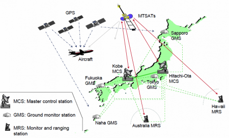
[[File:MSAS_Architecture.PNG|center|thumb|450px|MSAS Architecture]] | [[File:MSAS_Architecture.PNG|center|thumb|450px|MSAS Architecture]] | ||
Revision as of 06:41, 2 August 2011
| MSAS | |
|---|---|
| Title | MSAS Ground Segment |
| Author(s) | GMV. |
| Level | Basic |
| Year of Publication | 2011 |
The MTSAT Satellite Augmentation System (MSAS) is the Japanese Satellite Based Augmentation System (SBAS) System:[1] a GPS Augmentation system with the goal of improving its accuracy, integrity, and availability, and that uses the Multifunctional Transport Satellites (MTSAT) owned and operated by the Japanese Ministry of Land, Infrastructure and Transport and the Japan Meteorological Agency (JMA).
First tests were accomplished successfully, and MSAS system for aviation use was declared operational in September 27, 2007,[2][3] providing a service of horizontal guidance for En-route through Non-Precision Approach.[1][2][4]
MSAS Ground Segment
MSAS works by processing GPS data collected by a network of reference stations to generate the SBAS message which is uploaded to the GEO satellites. The GEO satellites broadcast this information to the user receivers, which compute the aircraft positioning and inform on potential alert messages.[4]
The MSAS system components are typically divided in three different segments: the ground segment, encompassing the system assets located on ground, the space segment, including the GEO satellites used to broadcast the information to the users, and the user segment, consisting in the users themselves.
The MSAS Ground Segment is composed of four Ground Monitor Station (GMS) that collect information on the GPS and MTSAT signals. They are placed on Sapporo, Tokyo, Fukuoka and Naha.[4]
The GMS stations send their data to two Master Control Station (MCS) in Kobe and Hitachiota, which compute precise differential corrections and integrity bounds and send them to the MTSAT satellites for rebroadcast to the User Segment.[4]
The MSAS Ground Segment is completed with two Monitor and Ranging Station (MRS) in Hawaii (USA) and Canberra (Australia), whose purpose is primarily the correct orbit determination of the MTSAT satellites, and they also work as GMS stations. [4]
Notes
References
- ^ a b MSAS Current Status, Japan Civil Aviation Bureau, Second Meeting of the International Committee on Global Navigation Satellite Systems (ICG) organized by the International Space Research Organization, Bangalore, India , 5 - 7 September 2007
- ^ a b QZSS / MSAS Status, CGSIC –47th Meeting ,Fort Worth, Texas September25, 2007, Satoshi KOGURE, Japan Aerospace Exploration Agency, QZSS Project Team
- ^ Eric Gakstatter, Perspectives - Late April 2008, GPSworld, April 15, 2008
- ^ a b c d e Overview of MSAS, Presentation for ICG-3, 2008

