If you wish to contribute or participate in the discussions about articles you are invited to contact the Editor
WAAS Space Segment: Difference between revisions
(Created page with "{{Article Infobox2 |Category=WAAS |Title={{PAGENAME}} |Authors=GMV. |Level=Basic |YearOfPublication=2011 |Logo=GMV }} The Wide Area Augmentation System (WAAS) is an GPS Augmenta...") |
|||
| Line 15: | Line 15: | ||
[[File:FAA WAAS System Overview.jpg|WAAS System|300px|thumb]] | [[File:FAA WAAS System Overview.jpg|WAAS System|300px|thumb]] | ||
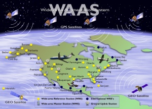
*The WAAS Space Segment consists of multiple geosynchronous communication satellites (GEO) | *The WAAS Space Segment consists of multiple geosynchronous communication satellites (GEO) which broadcast the correction messages generated by the Wide-area Master Stations for reception by the User segment. The satellites also broadcast the same type of range information as normal GPS satellites, effectively increasing the number of satellites available for a position fix. As of January 2011, the Space segment consists of two commercial satellites, Inmarsat-4 F3 and Telesat's Anik F1R, with Intelsat's Galaxy 15 planned to resume service before March, 2011.<ref>[http://www.faa.gov/about/office_org/headquarters_offices/ato/service_units/techops/navservices/gnss/waas/news/ FAA WAAS News]</ref> | ||
==Notes== | ==Notes== | ||
Revision as of 14:28, 16 June 2011
| WAAS | |
|---|---|
| Title | WAAS Space Segment |
| Author(s) | GMV. |
| Level | Basic |
| Year of Publication | 2011 |
The Wide Area Augmentation System (WAAS) is an GPS Augmentation system developed by the Federal Aviation Administration (FAA), with the goal of improving its accuracy, integrity, and availability. Essentially, WAAS is intended to enable aircraft to rely on GPS for all phases of flight, including precision approaches to any airport within its coverage area.
WAAS uses a network of ground-based reference stations, in North America and Hawaii, to measure small variations in the GPS satellites' signals in the western hemisphere. Measurements from the reference stations are routed to master stations, which queue the received Deviation Correction (DC) and send the correction messages to geostationary WAAS satellites in a timely manner (every 5 seconds or better). Those satellites broadcast the correction messages back to Earth, where WAAS-enabled GPS receivers use the corrections while computing their positions to improve accuracy.[1]
WAAS Space Segment
- The WAAS Space Segment consists of multiple geosynchronous communication satellites (GEO) which broadcast the correction messages generated by the Wide-area Master Stations for reception by the User segment. The satellites also broadcast the same type of range information as normal GPS satellites, effectively increasing the number of satellites available for a position fix. As of January 2011, the Space segment consists of two commercial satellites, Inmarsat-4 F3 and Telesat's Anik F1R, with Intelsat's Galaxy 15 planned to resume service before March, 2011.[2]

