If you wish to contribute or participate in the discussions about articles you are invited to contact the Editor
EGNOS Space Segment: Difference between revisions
Jump to navigation
Jump to search
Jon.Caudepon (talk | contribs) |
Jon.Caudepon (talk | contribs) |
||
| Line 22: | Line 22: | ||
==The Inmarsat-3 Satellite-Navigation Mission== | ==The Inmarsat-3 Satellite-Navigation Mission== | ||
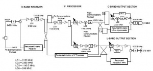
Inmarsat’s Third Generation satellites carry a navigation payload which is used by EGNOS. | |||
[[File:Inmarsat-3_Nav_Payload.JPG| Inmarsat-3 Navigation Payload block diagram |300px|thumb|right]] | [[File:Inmarsat-3_Nav_Payload.JPG| Inmarsat-3 Navigation Payload block diagram |300px|thumb|right]] | ||
Revision as of 14:41, 4 May 2011
| EGNOS | |
|---|---|
| Title | EGNOS Space Segment |
| Author(s) | GMV. |
| Level | Basic |
| Year of Publication | 2011 |
The EGNOS space segment is composed by three geostationary satellites centred over Europe:
- Inmarsat-3 AOR-E (Atlantic Ocean Region East) stationed at 15.5° W.
- Inmarsat-3 IOR-W (Indian Ocean Region West) stationed at 25.0°E.
- ESA-Artemis stationed at 21.5° E.
The main criteria followed in the selection of the satellites positions have been:
- Improve the measurement geometry and hence the system availability.
- Maximise the visibility angle diversity and hence minimise the risk of signal blocking.
- Provide dual geostationary coverage (minimum) within the core service area.
Inmarsat’s Third Generation satellites carry a navigation payload which is used by EGNOS.
ESA Artemis Navigation Payload

