If you wish to contribute or participate in the discussions about articles you are invited to contact the Editor
EGNOS Commercial Data Distribution Service: Difference between revisions
Jon.Caudepon (talk | contribs) No edit summary |
Jon.Caudepon (talk | contribs) No edit summary |
||
| Line 105: | Line 105: | ||
* EDAS Client Software (CS): represents the functional interface between the EGNOS Data Server (EDS) and the Service Provider (SP) and it provides authentication, data communication and quota and integrity management. | * EDAS Client Software (CS): represents the functional interface between the EGNOS Data Server (EDS) and the Service Provider (SP) and it provides authentication, data communication and quota and integrity management. | ||
* EGNOS Data Server: transforms data received from the INSPIRE interface from the EGNOS proprietary format to ASN.1 (SL0) and RTCM (SL1). For each message received EDS creates one or more RTCM messages and one ASN.1 message. Besides, raw ATC data are provided for both levels and delivers, to each authenticated CS, only those messages created for the SP Service Level subscriptions. In addition it delivers information to the CS about the status of the messages quota contracted by the SP. | * EGNOS Data Server: transforms data received from the INSPIRE interface from the EGNOS proprietary format to ASN.1 (SL0) and RTCM (SL1). For each message received EDS creates one or more RTCM messages and one ASN.1 message. Besides, raw ATC data are provided for both levels and delivers, to each authenticated CS, only those messages created for the SP Service Level subscriptions. In addition it delivers information to the CS about the status of the messages quota contracted by the SP. | ||
[[File:EDAS_CS.JPG | EDAS high level architecture. |250px|thumb|right]] | |||
Revision as of 15:46, 25 April 2011
| EGNOS | |
|---|---|
| Title | EGNOS Commercial Data Distribution Service |
| Author(s) | GMV. |
| Level | Basic |
| Year of Publication | 2011 |
The EGNOS Commercial Data Distribution Service (CDDS) represents the provision of additional data for professional users not provided by the EGNOS signal broadcast by geostationary satellites but by other distribution channels. The CCDS will be offered on a controlled access basis, i.e. Internet based resources or cellular phones, and is intended for ground based customers who require enhanced performances for commercial and professional users. The Service has not yet been declared available and a dedicated Service Definition Document (SDD) will be published upon its declaration.
First step towards EGNOS CDDS: [EDAS | EGNOS Data Access System (EDAS) ]]
In order to gather user requirements for the final CDDS, The European Commission has leaded an initiative, The EGNOS Data Access System (EDAS), to provide EGNOS data by making the following services available:[1]
- Transmission of EGNOS messages via the Radio Data System (RDS) and Digital Audio Broadcast (DAB).
- Transmission of EGNOS data using the RTCM SC 104 standard (directly usable by maritime DGPS receivers).
- Transmission in real time of EGNOS system performance information.
- Access to raw data from the RIMS network receivers.
EDAS is the technical implementation of the EGNOS CDDS, it will constitute the means for the EGNOS multimodal service growth and introduction of the EGNOS CDSS and represents the main interface point for multimodal Service Providers to deliver EGNOS products in real-time, within guaranteed performance boundaries.[2]
EDAS is provided by the European Satellite Service Provider (ESSP), it is the single point of access for the data collected and generated by the EGNOS infrastructure and it represents an intermediate step towards the definition of the EGNOS CDDS by the European Commission.[3]
EGNOS CDDS Applications
Service providers can exploit the CDDS to provide added value to final users in various domains and applications such as the ones highlighted:
- Applications for individual handsets and mobile phones (LBS)
- Road transport
- Maritime & Rail transport
- Civil protection and surveillance
Location Based Services (LBS)
The LBS sector include GNSS-enabled mobile phones, smartphones and services, and represents 52% of the global GNSS market.[4] To promote the development of EGNOS/EDAS based LBS applications, the EC has funded R&D projects to provide toolkits for manufacturers.
In urban areas where acquiring satellite signals may be difficult and often provokes a loss of accuracy and performance degradation, EGNOS corrections could still be applied through the EGNOS CDDS. Some of the latest R&D projects developed in this frames are listed bellow and a the complete list of ongoing projects is described in detail in the EC GNNS Applications site.[4]
- PERNASVIP: to develop a GNSS-based mobility service dedicated to visually disabled pedestrians in urban environment.[5]
- ATLAS: concerns the development of an assurance and authentication service for GNSS-derived time and position information for use in liability-critical LBS applications across a wide variety of market sectors.[6]
Road Applications
Intelligent transport systems for road transport represent an important segment of the GNSS market. The wide range of applications do not only cover in-car navigation, but also user charging for an efficient use of the road infrastructure, fleet management and logistics. Road User Charging (RUC) is becoming a strategy for authorities to manage increasingly congested road networks throughout Europe. This approach implies recording journey information by using a GNSS receiver embedded in an OBU and such solutions aided by EGNOS through CDDS have been widely analyzed.[7]
The EC contributes to the development of EGNOS based technologies for road applications by promoting contracts in this framework. Some of these projects are briefly presented hereafter:[4]
- GINA: aims at investigating the factors which could enable the application of GNSS-based road pricing followed by a nationwide demonstration in the Netherlands.[8]
- SIGNATURE: develops new features improving road user charging in terms of charging accuracy (correct cost per trip),charging integrity (probability and amount of overcharging) and charging availability (amount of charged usage).[9]
- GALAPAGOS: develops a positioning system for logistic applications with a special focus on container tracking.[10]
Rail and Maritime Applications
The Mediterranean Introduction of GNSS Services (METIS)[11] is an EGNOS demonstration that implements EGNOS use in transport domains over the Euro-Mediterranean area, to prepare market for Galileo.
This project relies not only on the EGNOS Signal In Space (SIS) but also on the distribution of EGNOS products via EDAS. Moreover it identified opportunities for EGNOS CDDS in the Mediterranean area for the next decade by proving technical feasibility and quantified benefits.
SAFEPORT[12] is another project developed in the frame of Active Vessel Traffic Management that exploits the EGNOS accuracy, reliability and safety of life aspects by means of the EGNOS [ EGNOS Safety of Life Service| Safety of Life]] and CDDS services.
EGNOS Data Access System (EDAS)
EDAS is the technical core of the EGNOS Commercial Data Distribution Service (CDDS) and provides de opportunity to deliver EGNOS data to users who cannot always view the EGNOS satellites (such as in urban canyons) or to support a variety of other value added services, applications and research programs.[13]
In 2006, the European Commission through the GJU (now superseded by GNSS Supervisory Authority, the GSA) commissioned the EDAS system. EDAS allows any authorised entity to plug into EGNOS to receive the internal data collected, generated and delivered by EGNOS for free. Although the idea of providing GNSS data streams in real time is far from being new, EDAS has some key differentiators, the most important one is probably the service reliability planned for the post-beta test phase. Other benefits that EDAS brings are the high data rate (1Hz), the dissemination of the EGNOS message broadcast by each GEO satellite and the provision of GLONASS raw measurements. Additionally EDAS provides the raw data of the 34 Ranging and Integrity Monitoring Stations (RIMS) and Navigation Land Earth Stations (NLES).[13]
EDAS Overview
The main purpose of EDAS is to provide a basis for new applications beyond those from the nominal EGNOS Open Service and Safety of Life Service. To do so, the objective is to provide an interface point where multiple EGNOS Multimodal Service Providers can obtain the EGNOS products in real-time and within guaranteed delay, security, safety and performance boundaries. As a result EGNOS information broadcast through the GEO Signal In Space (SIS) becomes accessible, as well as the EGNOS Ranging, Integrity and Monitoring Stations (RIMS) raw data. EDAS will deliver two main types of data in real-time, via ground transmission systems:
- EGNOS augmentation messages, also transmitted by EGNOS geostationary satellites.
- Raw GPS data collected by the EGNOS monitoring reference network.
The key differences between EDAS and other reference networks are:
- Increased reliability and performance based on EGNOS core infrastructure
- Additional data provided
- Possibility of binding and long-term service agreements.
EDAS Services
EDAS provides two different service levels, which basically differ in the data formats they provide, namely RTCM and ASN.1. EDAS is not an end-user product. The data streams can be used by Service Providers to generate added value to the final customers by improving the availability and accuracy of the positioning. For instance, one may think of a Service Provider that takes the EGNOS message from EDAS and disseminates it to its customers through the Internet or GPRS. The focus of the specified services is defined hereafter:
- Service Level (SL) 0: needed to transmit raw data in a format that allows a lossless reconstruction after translation.
- Service Level (SL) 1: used to transmit filtered data in an open standard. The Service Provider may split the incoming data stream to further groups (GPS, GLONASS, SBAS…).
EDAS Architecture
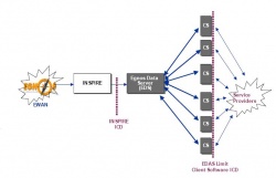
The EDAS architecture is composed of the following elements:
- EDAS Client Software (CS): represents the functional interface between the EGNOS Data Server (EDS) and the Service Provider (SP) and it provides authentication, data communication and quota and integrity management.
- EGNOS Data Server: transforms data received from the INSPIRE interface from the EGNOS proprietary format to ASN.1 (SL0) and RTCM (SL1). For each message received EDS creates one or more RTCM messages and one ASN.1 message. Besides, raw ATC data are provided for both levels and delivers, to each authenticated CS, only those messages created for the SP Service Level subscriptions. In addition it delivers information to the CS about the status of the messages quota contracted by the SP.
Notes
References
- ^ EGNOS User Guide for Developers
- ^ The vehicle to the future EGNOS CDDS
- ^ ESSP Web Site
- ^ a b c GNSS Applications EC Portal
- ^ PERNASVIP Web
- ^ ATLAS Project
- ^ SIGNATURE
- ^ GINA Project
- ^ SIGNATURE Project
- ^ GALAPAGOS Project
- ^ EGNOS demonstrations in the Mediterranean Area
- ^ SAFEPORT Project
- ^ a b The EGNOS Service to Provide Ground Based Access to EGNOS – EDAS Beta test findings; Reinhard Blasi, GSA; Rafael Cardoso-Herce, Didier De Greef, ESSP; José Ramón López-Pérez, Francisco J. Jiménez-Roncero, AENA; Ángel Gavín-Alarcón, GMV; Monica Pesce, VVA


